River Crafnant

River Crafnant

Geobox|River
name = River Crafnant
native_name = Afon Crafnant
other_name =
other_name1 =


image_size = 250px
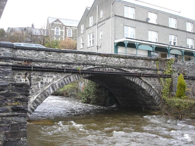
image_caption = The River Crafnant at Trefiw
etymology =
country = Wales | country_

country1 =
state =
state1 =
region =
region1 =
district =
district1 =
city =
city1 =
landmark =
landmark1 =
length_imperial = 2.5
watershed =
discharge_location =
discharge =
discharge_max =
discharge_min =
discharge1_location =
discharge1 =
source_name = Llyn Crafnant
source_location =
source_district =
source_region =
source_state =
source_country =
source_lat_d =
source_lat_m =
source_lat_s =
source_lat_NS =
source_long_d =
source_long_m =
source_long_s =
source_long_EW =
source_elevation =
source_length =
mouth_name = confluence with Afon Conwy
mouth_location =
mouth_district =
mouth_region =
mouth_state =
mouth_country =
mouth_lat_d =
mouth_lat_m =
mouth_lat_s =
mouth_lat_NS =
mouth_long_d =
mouth_long_m =
mouth_long_s =
mouth_long_EW =
mouth_elevation =
tributary_left =
tributary_left1 =
tributary_right = Geirionydd
tributary_right1 =
free_name =
free_value =


map_size =
map_caption =

The River Crafnant ("Afon Crafnant" in Welsh) is a tributary of the River Conwy ("Afon Conwy" in Welsh), which is the main river of the Conwy valley in North Wales.

It flows from picturesque Llyn Crafnant, joining the river Conwy at Trefriw. It is about 2.5 miles in length.

The river Crafnant itself has a tributary, the river Geirionydd which flows from Llyn Geirionydd. These two join a little below the former Klondyke Mill, which used water from both rivers. Klondyke was a mining and milling complex connected with some of the metal mines of the Gwydir Forest.

The river Crafnant is also fed by a number of unnamed streams draining from Cefn Cyfarwydd, the ridge to the north-west.

At Trefriw water is extracted to pass through the woollen mill to generate hydro-electricity for the mill.

Coed Crafnant, an area of woodland in the valley, is managed by the North Wales Wildlife Trust.

Cwm Glas Crafnant is a National Nature Reserve administered by the Countryside Council for Wales.

External links

* [http://www.t-w-m.co.uk/ Trefriw Woollen Mills]


Wikimedia Foundation. 2010.

Игры ⚽ Поможем написать курсовую

Look at other dictionaries:

  • River Conwy — Conwy (Afon Conwy) River Boats in the river estuary at Conwy …   Wikipedia

  • River Geirionydd — Geobox|River name = River Geirionydd native name = Afon Geirionydd other name = other name1 = image size = 250px image caption = The River Geirionydd near Klondyke mill etymology = country = Wales | country country1 = state = state1 = region =… …   Wikipedia

  • River Conwy — Boote auf dem Conwy Der Conwy (walisisch: Afon Conwy) ist ein Fluss im nördlichen Wales. Von seiner Quelle bis zur Mündung in die Conwy Bay in der irischen See ist der Fluss etwas länger als 43 Kilometer. Der Conwy entsteht in der Migneint Heide …   Deutsch Wikipedia

  • Llyn Crafnant — Infobox lake lake name = Llyn Crafnant image lake = Crafnant from Crimpiau.jpg caption lake = View from the summit of Crimpiau image bathymetry = caption bathymetry = location = North Wales coords = coord|53|7|57|N|3|52|12|W|type:waterbody region …   Wikipedia

  • Trefriw — infobox UK place country = Wales welsh name= constituency welsh assembly= map type= official name= Trefriw population= 1,338 (2001 census) unitary wales= Conwy lieutenancy wales= Clwyd constituency westminster= Meirionnydd Nant Conwy post town=… …   Wikipedia

  • Conwy — This article is about the town. For other uses, see Conwy (disambiguation). Coordinates: 53°17′N 3°50′W / 53.28°N 3.83°W / 53.28; 3.83 …   Wikipedia

  • Dolgarrog — is a small village in the Conwy County Borough in North Wales situated between Llanrwst and Conwy, very close to the Conwy River. The village is well known for its industrial history since the 18th century and the Eigiau dam disaster, which… …   Wikipedia

  • Maenan — is a rural community in Conwy, Wales, located approximately 4 miles to the north of Llanrwst and 3 miles to the south of the village of Eglwysbach. The population of the area is approximately 300 people, and more than 75% of the population are… …   Wikipedia

  • Llanfair Talhaiarn — (also spelled Llanfair Talhaearn and sometimes abbreviated by English speakers to Llanfair TH) is a village approximately 5 miles south of Abergele in Conwy county borough, Wales, formerly in Denbighshire. The village derives its name from the… …   Wikipedia

  • Conwy County Borough — Bwrdeistref Sirol Conwy County Borough Geography Area Total  % Water Ranked 6th 1,130 km² ? % …   Wikipedia

Share the article and excerpts

Direct link
Do a right-click on the link above
and select “Copy Link”