Molesworth Station

Molesworth Station
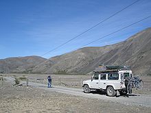
Molesworth station includes high-country areas.

Molesworth Station is New Zealand's largest farm, at over 1,800 km²,[1] and supports the country's biggest herd of cattle. It also hosts government science programs, such as research into bovine tuberculosis and related research into possums.[2]

The land is owned by the Crown and is leased for farming. On 1 July 2005, administration of the land was handed to the New Zealand Department of Conservation.[1]

The HVDC Inter-Island transmission line travels trough the station.

See also

  • Station (New Zealand agriculture)
  • Wards Pass

References

External links

Coordinates: 42°14′10″S 173°03′25″E / 42.236°S 173.057°E / -42.236; 173.057


Wikimedia Foundation. 2010.

Игры ⚽ Нужна курсовая?

Look at other dictionaries:

  • Molesworth Station — 42° 14′ 10″ S 173° 03′ 25″ E / 42.236, 173.057 Molesworth Sta …   Wikipédia en Français

  • Molesworth railway station — Molesworth Station information Line Mansfield Distance from Southern Cross  ? Number of platforms  ? Number of tracks  ? Stat …   Wikipedia

  • Station (Nouvelle-Zélande) — Pour les articles homonymes, voir Station. Station à moutons de Walter Peak, en Nouvelle Zélande Une station en Nouvelle Zélande est une grande ferme d éleva …   Wikipédia en Français

  • Molesworth, Victoria — Molesworth Victoria Molesworth Hall …   Wikipedia

  • RAF Molesworth — Royal Air Force Molesworth USAAF Station 107 …   Wikipedia

  • Wadebridge railway station — Infobox UK disused station name = Wadebridge latitude = 50.514933 longitude = 4.833402 caption = manager = Bodmin and Wadebridge Railway London and South Western Railway owner = Southern Railway Western Region of British Railways locale =… …   Wikipedia

  • Naval Air Station Keflavik — For the civil airport use of this facility, see Keflavík International Airport. Naval Air Station Keflavik Located at Keflavík International Airport, Iceland …   Wikipedia

  • Cheviot railway station — Cheviot Station information Line Mansfield Station status Closed Station opened 10 June 1890 Station closed 8 November 1978 Cheviot is a former railway station in …   Wikipedia

  • Hanmer Springs — Location map New Zealand label=Hanmer Springs lat dir=S | lat deg=42 | lat min=31 lon dir=E | lon deg=172 | lon min=49 position=right width= 150 float=right caption=Hanmer Springs (often misspelled and mis pronounced Hamner Springs) is a small… …   Wikipedia

  • Clarence River (New Zealand) — The Clarence River system. A view over the river mouth near Kaikoura …   Wikipedia

Share the article and excerpts

Direct link
Do a right-click on the link above
and select “Copy Link”