Deighton, North Yorkshire — may refer to Deighton, Hambleton, North Yorkshire, England Deighton, York, North Yorkshire, England This disambiguation page lists articles about distinct geographical locations with the same name. If an … Wikipedia
Deighton — People named Deighton Jeremy Deighton, American soccer player John Deighton (bar owner) Len Deighton (author) Michelle Deighton (model) Ernest Deighton (flying ace) Places named Deighton Deighton, Hambleton, North Yorkshire Deighton, West… … Wikipedia
List of civil parishes in North Yorkshire — This is a list of civil parishes in the non metropolitan county of North Yorkshire, England, and the non metropolitan districts of Middlesbrough, Redcar and Cleveland, Stockton on Tees (south of the river) and York.CravenCraven is entirely… … Wikipedia
Northallerton — Coordinates: 54°20′16″N 1°25′43″W / 54.3378°N 1.4285°W / 54.3378; 1.4285 … Wikipedia
Kirklees — For the medieval village of the same name, see Kirklees, West Yorkshire. Coordinates: 53°35′35″N 1°48′04″W / 53.593°N 1.801°W / 53.593; 1.801 … Wikipedia
A19 road — UK road routebox road= A19 length mi= length km= direction= North South start= Doncaster destinations= York Thirsk Teesside Middlesbrough Sunderland Tyne Tunnel end= Seaton Burn construction date= completion date= junctions= ukroadsmall|1… … Wikipedia
Appleton Wiske — infobox UK place country = England latitude = 54.4365 longitude = 1.3978 official name = Appleton Wiske static static image caption = Appleton Wiske population = shire district = Hambleton region = Yorkshire and the Humber shire county = North… … Wikipedia
List of District Health Authorities in England and Wales — District Health Authorities were administrative units of the National Health Service in England and Wales from 1982 to 1996. The districts were a second tier below the health regions. They replaced the Area Health Authorities (which generally… … Wikipedia
Selby (district) — Infobox UK district name = Selby District status = District region = Yorkshire and the Humber admincounty = North Yorkshire area = Ranked 76th 599.31 km² adminhq = Selby onscode = 36UH population = Ranked English district rank|ONS=36UH English… … Wikipedia
List of Sites of Special Scientific Interest in North Yorkshire — This is a list of the Sites of Special Scientific Interest (SSSIs) in North Yorkshire. Note that Natural England, the designating body for SSSIs in England, uses the 1974–1996 county system, and this list follows the same approach, rather than,… … Wikipedia
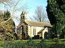 All Saints Church, Deighton
 Media related to Deighton, Hambleton at Wikimedia CommonsCategories: