- Litoměřice
Geobox | Settlement
name = Litoměřice
other_name =
category = Town
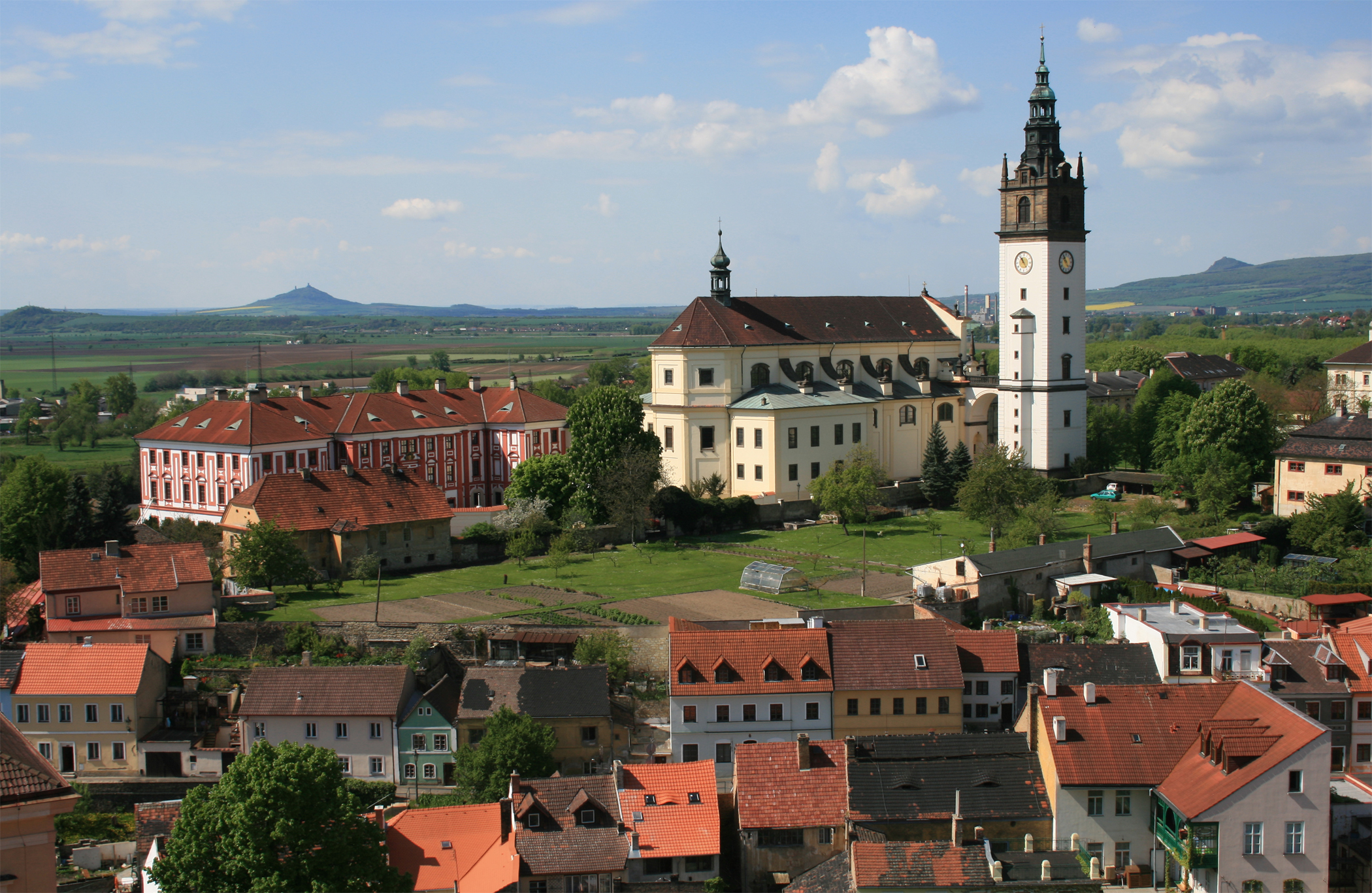
image_caption = Cathedral of St. Stephen with belfry.
image_caption = Cathedral of St. Stephen with belfry.
 | flag_border = 1
symbol = Znak města Litoměřice.gif
etymology =
official_name =
motto =
nickname =
country = Czech Republic
country_
state =
region = Ústí nad Labem
region_type = Region
district = Litoměřice
district_type = District
commune = Litoměřice
municipality =
part =
river =Elbe ,Ohře
location =
elevation = 136
lat_d = 50
lat_m = 32
lat_s = 3
lat_NS = N
long_d = 14
long_m = 7
long_s = 58
long_EW = E
highest =
highest_elevation =
highest_lat_d =
highest_long_d =
lowest =
lowest_elevation =
lowest_lat_d =
lowest_long_d =
area = 17.99
area_round = 2
population = 25517
population_date = 2006-10-02
population_density = auto
established = 10th century
established_type = Founded around
established1 = 1219
established1_type = Royal status
mayor = Ladislav Chlupáč
timezone =
map_background = Czechia - background map.png
map_locator = Czechia
commons = Litoměřice
statistics = [http://www.statnisprava.cz/ebe/ciselniky.nsf/i/564567 statnisprava.cz]
website = [http://www.litomerice.cz// www.litomerice.cz/]
footnotes =Litoměřice (IPA2|ˈlɪtomɲɛr̝ɪtsɛ; _de. Leitmeritz) is a town at the junction of the rivers
Elbe ( _cs. Labe) andOhře ( _de. Eger) in the north part of theCzech Republic , approximately 64 km (39,7 mi) northwest ofPrague .The area within the
Ústí nad Labem Region is called "Garden ofBohemia " thanks to mild weather conditions important for growing fruits andgrape s. During the time of theAustro-Hungarian Empire , many pensionists chose it over more southern areas of the Empire.History
One of the oldest Czech towns, Litoměřice was established in the 10th century at the place of an early medieval Slavic fort. The royal town statute was granted in 1219. From the 12th to the 17th century it was a significant trade center in the
Holy Roman Empire . The German population suffered during the 15th centuryHussite Wars . After the Protestant insurrection that triggered theThirty Years' War , and their defeat in theBattle of White Mountain , the population of the city had to acceptCatholicism , or leave the town, which became a bishop residency in 1655. As a result, the Czech population shrunk and the town became largely Germanized.Fact|date=February 2007After the
Austro-Hungarian Empire was dissolved in late 1918, the areas along the border with Germany, where a majority of the former Austrian citizens were speakingGerman language , tried to joinGerman Austria (which in turn aimed to join Germany), but Czechoslovak troops prevented this. In 1919, all of Bohemia andMoravia was put under the Czechoslovak rule by theTreaty of St. Germain , including the large area stretching around central Bohemia and Moravia, which became asSudetenland a matter of political controversy in the following years. Slavs settled there again, but remained a minority. In 1938, after theMunich Agreement , German troops occupied theSudetenland . The Czech population that had grown to about 5,000 people had to leave again.In the final stages of the
World War II , German troops were retreating to escape the advancingRed Army . Czech resistance took control of the castle on27 April 1945 , and after a few days they started negotiation with the Nazi commander about the terms of his surrender. TheWehrmacht capitulated in the night after8 May , but German troops fled on9 May just before Soviet troops entered the town on10 May 1945 . Most of the German population of the town was expelled byBeneš decrees in August of 1945 along with about 2.5 million other Czechoslovak citizens of German ethnicity.ights
The symbol of the city is a chalice, since the watchout tower on the Town Hall has this shape. There are numerous cellars connected by an extensive web of underground ways under the town. In some places the cellars were built in three floors. The ways are about three kilometers long and they belong to one of the longest in the Czech Republic. Unfortunately, only 336 meters of these underground ways are open to public. One can notice the ancient town wall when entering the town. The original town wall was built in the Gothic style.
Population
*
1 December 1930 : 18,498
*17 May 1939: 17,267
*22 May 1947 : 14,402
*2 June 2004 : 25,517Notables
The greatest representative of Czech romanticism,
Karel Hynek Mácha , died in Litoměřice, shortly after he had moved to the town, and was buried there. Later his grave was moved to Prague where he is buried now at theVyšehrad cemetery .Josef Jungmann , creator of the modern Czech language, lived and taught here from 1799 to 1815.Štěpán Cardinal Trochta was a bishop of Litoměřice from 1947.
The
Master of the Litoměřice Altarpiece received his name from this town.Karel Pejml, co-founder of modern
historical climatology , lived here from 1978 to 1989.Ferdinand Blumentritt , teacher, historian, ethnologist and close friend of the Philippine national heroJosé Rizal , lived and taught here 1877 - 1913.ister Cities
*
Calamba City , Philippines (1974)
*Meissen , Germany (1996)
*Fulda , Germany (2001)
*Dapitan , Philippines (2006)
*Armentieres , FranceExternal links
* [http://www.czech.cz/en/culture/most-beautiful-sights-and-places-of-interest/towns/other-remarkable-czech-towns/litomerice/ Litoměřice at the official website of the Czech Republic www.czech.cz] (in English)
* [http://www.litomerice.cz/ Official Website] cs icon
* [http://www.litomerice.cz/ger/ Official Website] de icon
* [http://www.litomerice.cz/eng/] eng icon


Wikimedia Foundation. 2010.