- Wendover Airport
Infobox Airport
name = Wendover Airport
nativename =
nativename-a =
nativename-r =
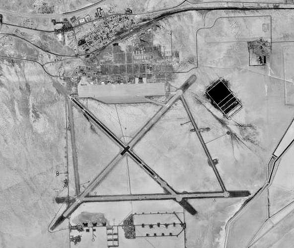
image-width =
caption =
IATA = ENV
ICAO = KENV
FAA = ENV
type = Public
owner =
operator = Port of West Wendover
city-served =
location = Wendover, Utah
elevation-f = 4,237
elevation-m = 1,291.4
coordinates = Coord|40|43|07|N|114|01|51|W|type:airport_region:US|display=inline,title
website =
metric-elev =
metric-rwy =
r1-number = 8/26
r1-length-f = 8,000
r1-length-m = 2,438
r1-surface =Asphalt
r2-number = 12/30
r2-length-f = 8,001
r2-length-m = 2,439
r2-surface = Asphalt
stat-year =
stat1-header =
stat1-data =
stat2-header =
stat2-data =
footnotes =Wendover Airport airport codes|ENV|KENV|ENV is a public
airport located one mile (1.6 km) southeast of thecentral business district (CBD) of Wendover, a city in Tooele County,Utah , USA.History
By
1965 , the airfield was closed. The non-flying components were inactivated in1969 , and the entire facility declared surplus in1976 . The facility was turned over to the town of Wendover as a municipal airport, named Decker Field.Beginning in
1980 the4440th Tactical Fighter Training Group (Red Flag),Nellis AFB ,Nevada , used Wendover for exercises, but they were discontinued after1986 .Today this former Air Force Base is still used as a civil airport, yet for such a huge facility (the longest runway is 9,900' long) it is all but abandoned, as only 11 aircraft are still based on the field.
Still-extant facilities include three paved runways, numerous ramps, taxiways, dispersal pads, all of the original hangars (including the "Enola Gay" B-29 hangar), and 75 other WW2-era buildings.
Several flying scenes for the
1997 movie "Con Air " were filmed at Wendover, using a Fairchild C-123K Provider. A non-profit group, Historic Wendover Airfield, is attempting to restore the historic elements of the field.The northeast/southwest runway is pretty much gone. It was used by USAF engineers training for runway demolition and repair. The east/west runway is new, put in only a couple of years ago in hopes of drawing commercial service.
Facilities
Wendover Airport covers convert|1960|acre|ha|0|lk=on and has two
runway s:
* Runway 8/26: 8,000 x 150 ft. (2,438 x 46 m), Surface:Asphalt
* Runway 12/30: 8,001 x 100 ft. (2,439 x 30 m), Surface: AsphaltAirlines and destinations
Currently, there is no scheduled airline service to Wendover. However,
Xtra Airways offers charter flights to various cities across the United States from Wendover usingBoeing 737-400 aircraft as part of a package deal to bring tourists to local casinos. On average, the airport will see one Xtra Airways flight per day.References
* [http://www.wendoverairbase.com/ Historic Wendover Airfield]
*FAA-airport|ID=ENV|use=PU|own=PU|site=25333.*AExternal links
Wikimedia Foundation. 2010.