Mansiri Himal

Mansiri Himal
Mansiri Himal
Range
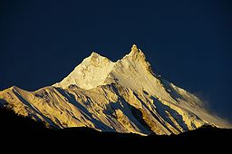
Sunrise over Manaslu
Country Nepal
Districts Gorkha, Manang, Lamjung
Part of Himalaya
Borders on Annapurna Himal, Peri Himal, Ganesh Himal, Serang (Sringi) Himal, Kutang Himal
Highest point Manaslu
 - elevation 8,156 m (26,759 ft)
 - coordinates 28°33′00″N 84°34′00″E / 28.55°N 84.5666667°E / 28.55; 84.5666667

Mansiri Himal is a small, high subrange.[1] of the Himalaya in north-central Nepal, about 100km northwest of Kathmandu. The Marsyangdi River separates the Mansiri from the Annapurnas to the southwest, then an upper tributary Dudh Khola separates Peri Himal to the northwest. On the east side, the Burhi (Budhi) Gandaki separates the Mansiri from Ganesh Himal, Serang or Sringi Himal and Kutang Himal.[2] All these streams are tributary to the Gandaki.

The Mansiri range is also known as Manaslu Himal or the Gurkha Massif. It contains these peaks among Earth's twenty highest (with at least 500m topographic prominence):

The Mansiri range is notable for its local relief. It rises 7,000 m (23,000 ft) above the Marsyangdi valley floor in less than 30 km (18 mi) horizontal distance.

Notes

  1. ^ H. Adams Carter (1985). "Classification of the Himalaya". American Alpine Journal (American Alpine Club) 27 (59): 109–141. http://c498469.r69.cf2.rackcdn.com/1985/109_carter_himalaya_aaj1985.pdf. Retrieved April 29, 2011. 
  2. ^ H. Adams Carter, op. cit.. p. 128. http://c498469.r69.cf2.rackcdn.com/1985/109_carter_himalaya_aaj1985.pdf. 

Wikimedia Foundation. 2010.

Игры ⚽ Нужна курсовая?

Look at other dictionaries:

  • Himal Chuli — von Süden Höhe 7.893 m …   Deutsch Wikipedia

  • Annapurna Himal — p1p5 Annapurna Himal …   Deutsch Wikipedia

  • Ganesh himal — Géographie Altitude 7 422 m, Yangra (Ganesh I) Massif …   Wikipédia en Français

  • Ganesh Himal — Géographie Altitude 7 422 m, Yangra (Ganesh I) Massif Himalaya …   Wikipédia en Français

  • Ganesh Himal — is a sub range of the Himalayan mountain range. It is located mostly in north central Nepal, but some peaks lie on the border with Tibet. TheTrisuli Gandaki valley on the east separates it from the Langtang Himal; the Budhi Gandaki valley and the …   Wikipedia

  • Liste der Berge oder Erhebungen in Nepal — In dieser Liste werden die höchsten Berge und Erhebungen Nepals auf dem Staatsgebiet von Nepal geführt, enthalten sind alle Erhebungen mit einer sogenannten Schartenhöhe von mindestens 150 Metern. Die Liste ist vollständig in dem Bereich von 6900 …   Deutsch Wikipedia

  • Liste von Bergen in Asien — Höchster Berg Asiens, zugleich der höchste Berg der Erde: Der Mount Everest In dieser Liste werden die höchsten Berge Asiens geführt. Enthalten sind alle Erhebungen mit einer sogenannten Schartenhöhe von mindestens 500 Metern. Die Liste ist… …   Deutsch Wikipedia

  • Manaslu — at sunrise Elevation 8,156 m (26,759 ft)  Ranked 8th …   Wikipedia

  • List of Nepal-related topics — This is a list of topics related to Nepal. Those interested in the subject can monitor changes to the pages by clicking on Related changes in the sidebar.Nepal* Nepal * Nepal, Travel information * * Nepal Bhasa * Institute of Medicine, Nepal *… …   Wikipedia

  • Himalchuli — Infobox Mountain Name = Himalchuli Photo = Caption = Elevation = 7,893 metres (25,896 feet) Ranked 18th Location = Gandaki Zone, Nepal Range = Mansiri Himal, Himalaya Prominence = 1,633 m Coordinates = coord|28|26|08|N|84|38|32|E|type:mountain… …   Wikipedia

Share the article and excerpts

Direct link
Do a right-click on the link above
and select “Copy Link”