- Tash-Kumyr
Infobox Settlement
official_name = Tash-Kumyr
native_name =Ташкөмүр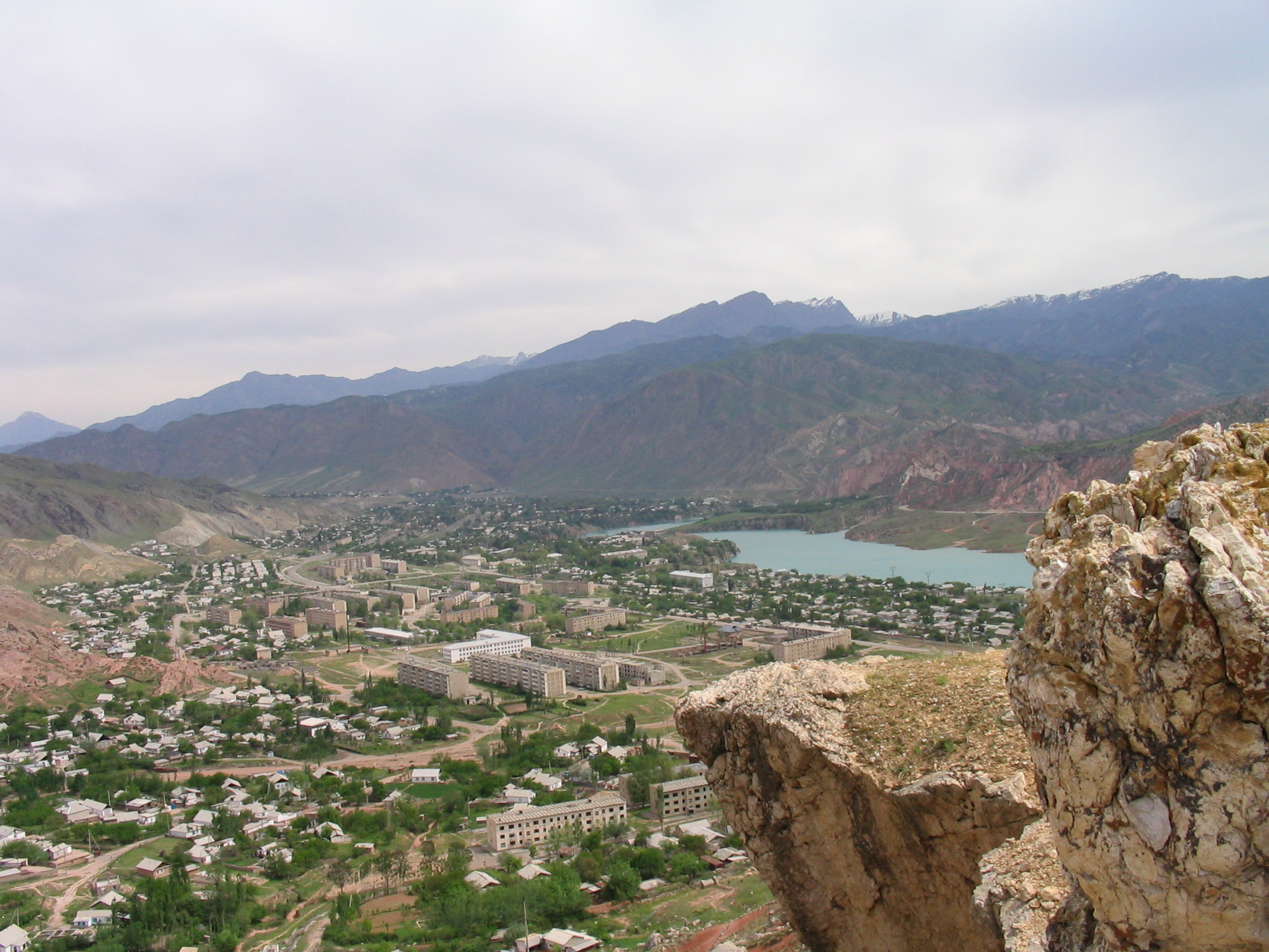
imagesize = 300px
image_caption = Tashkomur from Crocodile Mountain
image_
map_caption =
pushpin_
pushpin_label_position =bottom
pushpin_mapsize = 300
pushpin_map_caption =Location in Kyrgyzstan
subdivision_type = Country
subdivision_type1 = Province
subdivision_name =
subdivision_name1 =Jalal-Abad Province
subdivision_type2 =
subdivision_name2 =
established_title =
established_date =
government_type =
leader_title =
leader_name =
area_magnitude =
area_total_sq_mi =
area_total_km2 =
area_land_sq_mi =
area_land_km2 =
area_urban_sq_mi =
area_urban_km2 =
area_metro_km2 =
area_metro_sq_mi =
population_as_of=
population_footnotes =
population_total =
population_urban =
population_metro =
population_density_sq_mi =
population_density_km2 =
timezone =
utc_offset =
timezone_DST =
utc_offset_DST =
latd=41|latm=21|lats=|latNS=N
longd=72|longm=13|longs=|longEW=E
elevation_footnotes=
elevation_m =
elevation_ft =
postal_code_type =
postal_code =
area_code =
website =
footnotes =Tash-Kumyr (Ташкөмүр), now written Tashkumyr or Tashkömür, is one of the five largest towns of
Jalal-Abad Province in SouthernKyrgyzstan . It is located along the West bank of theNaryn River , opposite the mainOsh -Bishkek road. Located at the edge of theTien Shan Mountains, when heading South from Bishkek, Tashkomur is the gateway to theFergana valley .History
Officially founded on
December 17 ,1943 , Tashkomur, meaning stone-coal, grew into one of the largest industrial centers of the Central Asian region of theSoviet Union . It was primarily a mining town, but had a cigarette factory and other industries as well, which complemented the output of the coal mines. A railroad was constructed, and trains transported the coal out of Tashkomur to all corners of the Soviet Union. At its peak, Tashkomur had a population of around 35,000.Dams constructed along the Naryn river transformed what used to be a stream into a sizeable river. Residents will also attest to a change in climate, which they attribute to the dams. Furthermore, the
Tashkomur dam and theShamaldysay dam raised the water level considerably, causing certain settlements to be submerged by the water. Despite the presence of the dams and hydroelectic plants, Tashkomur still does not have 100% reliable electricity.The Land and The People
Tashkomur is located in what could be described as a canyon, which the Naryn river runs through.
Fossil s ofdinosaur s and dinosaur eggs have been discovered in the area, andpaleontologist s have speculated that once the area was used by dinosaurs to lay their eggs. The mountains surrounding the town are rich in minerals, not only in coal, which gave Tashkomur its fame.The town spans about 5 kilometers (3.1 miles) north to south, but is less than a kilometer (0.6 miles) across. There is no arable land in Tashkomur, although just a few kilometers south the
Fergana Valley begins, and thecotton plantations are ubiquitous, alongside the melons and other crops.Tashkomur in divided into five neighborhoods: Severniy (the North), Bayetova, the Center, Dostuk, and the Mikrorayon. Each neighborhood has its own school, except for the center, where there are 3 schools.
The town of Tashkomur also oversees four villages: Shamaldysay, Kyzyl-Alma, Bazyl-Ata, and Mailisay. Shamaldysay, the largest of these four villages, has three schools (#2, #8, and #10) while the other three villages have only one school each (#11, #6, and #9 respectively).
At the time of its foundation, the population of Tashkomur was mostly Russian and ethnically non-
Kyrgyz . There was no grazable land, so the Kyrgyz had never settled there. After coal was discovered, Kyrgyz families began to move into town. Up until Kyrgyzstan's independence in 1991 the Kyrgyz were not the overwhelming majority. However, after the breakup of the Soviet Union, many Russians and residents of other nationalities began to leave. This was particularly the case up until 1995, when the biggest economic problems affected the town, which continue to this day (2006). Now the Kyrgyz population makes up over 90% of the population.Although only about 20 kilometers (12 miles) from the Uzbek border, Tashkomur does not have a large Uzbek population (less than 50 families). The total population of Tashkomur is estimated to be between 20-25,000, however the continuous emigration of its residents makes it hard to know exactly.The Local Economy
Ever since the mine was shut down and the factories closed, the town has been struggling to survive. The answer, for many, has been to emigrate to
Russia ,Kazakhstan , or simply to the capital, Bishkek. Most families claim at least one member working abroad to make ends meet. The men usually work construction jobs, while the women find jobs as saleswomen at the bazaars or stores. These migrant workers are usually seasonal: they leave in the early spring and return in the fall, since the cold in the North makes for hard working conditions. The remittances have allowed Tashkomur residents to retain a decent standard of living. In recent years, many have used the money to renovate their homes, to buyDVD players and satellite dishes, or to open stores, and try to start a business.As Uzbekistan has made it more difficult and expensive for goods to be exported south into, and through Uzbekistan, Tashkomur's major opening to the outside world has been severed and in turn, its ability to export any goods it might manufacture has dropped.
While during the Soviet era all apartment buildings had gas and working plumbing, this is no longer the case. Water delivery, especially to the homes on the edge of town, is not reliable. There is no hot water. This year (2006)
cell phone s finally reached Tashkomur, which had been one of the last towns in the country left without them. There is still no publicinternet access.

Wikimedia Foundation. 2010.