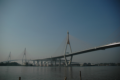
- Mega Bridge
Infobox Bridge
bridge_name = Dipangkorn Rasmijoti Bridge
caption =
official_name = Dipangkorn Rasmijoti Bridge
also_known_as = Mega Bridge
carries =
crosses =Chao Phraya River
locale =Bangkok ,Thailand
Maint =
design =Cable-stayed bridge
mainspan = 326 m and 398 m
length = 702m and 582 m
width =
clearance =
below =
traffic =
open =5 December 2006
closed =
toll =
map_cue =
map_
map_text =
map_width =
coordinates = coord|13|39|55|N|100|32|22|E|region:TH_type:landmark
lat =
long = The Dipangkorn Rasmijoti Bridge ( _th. สะพานทีปังกรรัศมีโชติ), unofficially known as the Mega Bridge, is part of the 13 km long Industrial Ring Road in connecting southernBangkok withSamut Prakan Province . This construction project comprises two strikingcable-stayed bridge s with lengths of 702 m and 582 m. The two pylons in the form of a diamond are 173 m and 164 m high.The bridge was to be officially opened in
5 December 2006 and named after PrinceDipangkorn Rasmijoti , the grandchild of KingBhumibol Adulyadej , however it was already opened for traffic in20 September 2006 . It is part of theOuter Ring Road (Motorway 9 of theThai motorway network )Contractor: TNNS Jointventure, Taisei, Nishimatsu, NKK, Sino Thai (
STECON )
Formwork Service: PERI-HORY Asia and PERI FormworkExternal links
* [http://www.peri.de/ww/en/projects.cfm/fuseaction/showreference/reference_ID/685/referencecategory_ID/2.cfm PERI - Weekly cycle of four 173 m high pylons simultaneously with PERI ACS]
* [http://2bangkok.com/2bangkok/Bridge/wongwein/wongwein.shtml 2bangkok.com on Mega bridge with many photos of the construction process]
* [http://maps.google.com/maps?q=Thailand&t=k&ie=UTF8&ll=13.659978,100.539086&spn=0.009987,0.021458&om=1 Map]
*
*Crossings navbox
structure= Crossings
place=Chao Phraya River
bridge= Mega Bridge
bridge signs=
upstream=Rama IX Bridge
upstream signs=
downstream=Kanchanaphisek Bridge
downstream signs=
Wikimedia Foundation. 2010.
