- Gaithersburg Latitude Observatory
Infobox_nrhp | name =Gaithersburg Latitude Observatory
nrhp_type = nhld
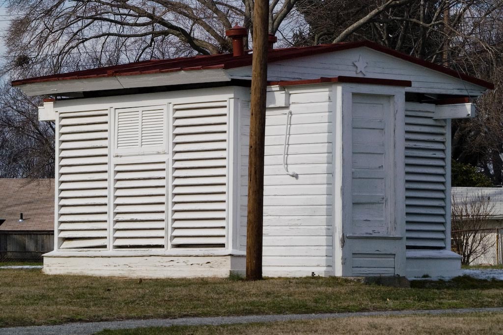
caption = Gaithersburg latitude observatory
location=Gaithersburg, Maryland
lat_degrees = 39
lat_minutes = 8
lat_seconds = 12
lat_direction = N
long_degrees = 77
long_minutes = 11
long_seconds = 57
long_direction = W
locmapin = Maryland
area =
built =1899
architect= Smith,Edwin
architecture= No Style Listed
added =July 12 ,1985
governing_body = Local
refnum=85001578cite web|url=http://www.nr.nps.gov/|title=National Register Information System|date=2007-01-23|work=National Register of Historic Places|publisher=National Park Service]The Gaithersburg Latitude Observatory, in
Gaithersburg, Maryland is one of the system of six International Latitude Observatories and (as of 2007) the onlyNational Historic Landmark in Gaithersburg, Maryland. [ [http://www.cr.nps.gov/nhl/designations/Lists/MD01.pdf PDF list] of National Historic Landmarks in Maryland, at the National Park Service website] The building is in theNational Register of Historic Places [ [http://www.nationalregisterofhistoricplaces.com/MD/Montgomery/state.html Montgomery County listings] at [http://www.nationalregisterofhistoricplaces.com National Register of Historic Places] ] . The GLO was constructed by Edwin Smith, chief of the Instrument Division of the U.S. Coast and Geodetic Survey. [http://www.cr.nps.gov/history/online_books/butowsky5/astro4i.htm National Park Service page about the Observatory] ]The Gaithersburg Latitude Observatory was one of six observatories — and one of the four original observatories built by 1899 [Publications of the Astronomical Society of the Pacific, [http://books.google.com/books?vid=0OQSQRmJoJUmXq1GunV&id=7wkAAAAAMAAJ Volume XI, Number 66] , 1899, pp 231-239] — tracking the degree of "wobble" occurring on the earth’s north-south axis. The Observatory — along with observatories in Cincinnati, Ohio; Ukiah, California; Mizusawa, Japan; Charjui in Russian Turkestan; and Carloforte, Sardina, Italy — performed close in concert carrying out a program of star study designed to investigate and calculate the earth “wobble” or latitude variation. [http://www.cr.nps.gov/history/online_books/butowsky5/astro4i.htm National Park Service page about the Observatory] ]
On the grounds of the Gaithersburg Latitude Observatory stands a plaque that reads:
:“This small framed structure played a key role in the scientific investigation of the Earth’s rotation. In 1898, the International Geodetic Association established a network of observatories to measure the wobble of the planet on its axis by plotting the locations of specific stars. This hilltop in Gaithersburg was chosen together with sites in California, Italy, Japan, and the Soviet Union. All five lay along the same latitude (39° 8’ N). The American Stations were supervised by the U.S. Coast and Geodetic Survey. The observatory’s roof was designed to part in the middle on two sets of tracks to expose the reflecting telescope inside to the night sky. Its slatted exterior walls stabilize the inside air to limit the effects of the temperatures on the accuracy of the telescope. The building’s white paint minimizes heat retention that creates air turbulence around the telescope at night, distorting the stars. Knowledge gained from the observations recorded here nightly until 1982 assisted scientists in the study of the Earth’s geophysical make-up and aided spacecraft orbiting the planer and navigating the universe.”
A second portion of the observatory was constructed to house the Photographic Zenith Tube. The observers used the Photographic Zenith Tube to capture picture data using the Zenith telescope as a guide of alignment and star track. [ [http://books.google.com/books?vid=0QOEi9AL9rF-sej-QY&id=dyYmAAAAMAAJ Geodesy: Latitude Observations with Photographic Zenith Tube at Gaithersburg MD] , Special Publication 27, by Frank E. Ross, PhD. US Coast and Geodetic Survey, US Department of Commerce, 1915; [http://books.google.com/books?vid=0QOEi9AL9rF-sej-QY&id=dyYmAAAAMAAJ&pg=PT26 this page] contains a photograph of the building with the addition intact.] Unfortunately, time has not been very kind to this addition of the Gaithersburg Latitude Observatory as it no longer stands at the site.
External links
* [http://hdl.loc.gov/loc.pnp/hhh.md1207 1989 Drawings] of the Gaithersburg Latitude Observatory at the
Library of Congress References
External links
* [http://www.marylandhistoricaltrust.net/nr/NRDetail.aspx?HDID=890&FROM=NRNHLList.aspx Gaithersburg Latitude Observatory, Montgomery County] , including photo in 1991, at Maryland Historical Trust
Wikimedia Foundation. 2010.