Łagów, Świebodzin County

Łagów, Świebodzin County

Infobox Settlement
official_name = Łagów
other_name =
native_name =
nickname =
settlement_type = Village
motto = Perła Ziemi Lubuskiej
Pearl of Lubusz Land
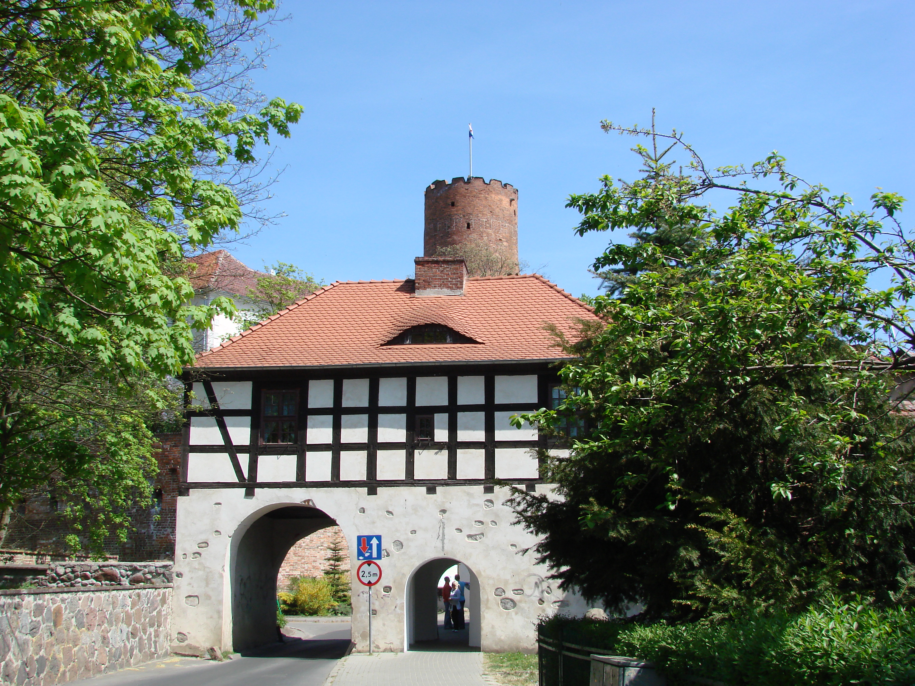


imagesize = 250px
image_caption = March of Brandenburg Gate and Tower


flag_size =
image_

seal_size =
image_shield = POL gmina Łagów COA.svg
shield_size =
city_
citylogo_size =


mapsize =
map_caption =


mapsize1 =
map_caption1 =
image_dot_

dot_mapsize =
dot_map_caption =
dot_x = |dot_y =
pushpin_

pushpin_label_position = bottom
pushpin_map_caption =
pushpin_mapsize =
subdivision_type = Country
subdivision_name = Poland
subdivision_type1 = Voivodeship
subdivision_name1 = Lubusz
subdivision_type2 = Powiat
subdivision_name2 = Świebodzin County
subdivision_type3 = Gmina
subdivision_name3 = Łagów
subdivision_type4 =
subdivision_name4 =
government_footnotes =
government_type =
leader_title = Mayor
leader_name = Jan Cybulski
leader_title1 =
leader_name1 =
leader_title2 =
leader_name2 =
leader_title3 =
leader_name3 =
leader_title4 =
leader_name4 =
established_title = Established
established_date = 13th century
established_title2 =
established_date2 =
established_title3 = City Rights
established_date3 = 1727-1932
area_magnitude =
unit_pref =
area_footnotes =
area_total_km2 =
area_land_km2 =
area_water_km2 =
area_total_sq_mi =
area_land_sq_mi =
area_water_sq_mi =
area_water_percent =
area_urban_km2 =
area_urban_sq_mi =
area_metro_km2 =
area_metro_sq_mi =
population_as_of = 2006
population_footnotes =
population_note =
population_total = 1600
population_density_km2 =
population_density_sq_mi =
population_metro =
population_density_metro_km2 =
population_density_metro_sq_mi =
population_urban =
population_density_urban_km2 =
population_density_urban_sq_mi =
population_blank1_title =
population_blank1 =
population_density_blank1_km2 =
population_density_blank1_sq_mi =
timezone = CET
utc_offset = +1
timezone_DST = CEST
utc_offset_DST = +2
latd=52 |latm=20 |lats= |latNS= N
longd=15 |longm=18 |longs= |longEW= E
elevation_footnotes =
elevation_m =
elevation_ft =
postal_code_type = Postal code
postal_code = 66-220
area_code = +48 68
blank_name = Car Plates
blank_info = FZW
blank1_name =
blank1_info =
website = [http://www.lagow.pl/ www.lagow.pl]
footnotes =
Łagów is a village in Świebodzin County, Lubusz Voivodeship, western Poland. The commune has 5,125 inhabitants and is a popular tourist destination. The town features a spectacular lake divided by the village center in the middle of the lake and also impressive woods full of mushrooms. It gives its name to a protected area called Łagów Landscape Park.

People

* Gerhard Domagk

References


Wikimedia Foundation. 2010.

Игры ⚽ Нужно сделать НИР?

Look at other dictionaries:

  • Świebodzin County — Infobox Settlement name = Świebodzin County native name = Powiat świebodziński settlement type = image shield = POL powiat świebodziński COA.svg map caption = Location within the voivodeship subdivision type = Country subdivision name = POL… …   Wikipedia

  • Łagów — is the name of several villages in Poland: *Łagów, Lower Silesian Voivodeship (south west Poland) *Łagów, Łódź Voivodeship (central Poland) *Łagów, Świętokrzyskie Voivodeship (south central Poland) * Łagów, Kielce County * Łagów, Krosno County *… …   Wikipedia

  • Łagów Landscape Park — Infobox protected area name=Łagów Landscape Park native name=Łagowski Park Krajobrazowy iucn category = V caption= location=Lubusz Voivodeship area=49.29 km² established=1985Łagów Landscape Park ( Łagowski Park Krajobrazowy ) is a protected area… …   Wikipedia

  • Gmina Łagów, Lubusz Voivodeship — Infobox Settlement name = Gmina Łagów other name = Łagów Commune settlement type = Gmina total type = Total image shield = POL gmina Łagów COA.svg subdivision type = Country subdivision name = POL subdivision type1 = Voivodeship subdivision name1 …   Wikipedia

  • Gmina Łagów — may refer to either of the following rural gminas (municipalities) in Poland: *Gmina Łagów in Kielce County, Świętokrzyskie Voivodeship *Gmina Łagów in Świebodzin County, Lubusz Voivodeship …   Wikipedia

  • Czyste, Lubusz Voivodeship — For other places with the same name, see Czyste (disambiguation). Czyste   Village   …   Wikipedia

  • Niedźwiedź, Lubusz Voivodeship — For other places with the same name, see Niedźwiedź (disambiguation). Niedźwiedź   Village   …   Wikipedia

  • List of Polish gminas/L — *Gmina Łabiszyn (urban rural, Żnin County, Kuyavian Pomeranian Voivodeship, 166.92 km², 9,435) *Gmina Łabowa (rural, Nowy Sącz County, Lesser Poland Voivodeship, 119.12 km², 5,172) *Gmina Łabunie (rural, Zamość County, Lublin Voivodeship, 87.48… …   Wikipedia

  • Toporów, Lubusz Voivodeship — Infobox Settlement official name = Toporów other name = (Topper) native name = nickname = settlement type = Village motto = imagesize = 250px image caption = Hunter s Palace flag size = image seal size = image shield = shield size = city citylogo …   Wikipedia

  • Gmina Lubrza, Lubusz Voivodeship — Infobox Settlement name = Gmina Lubrza other name = Lubrza Commune settlement type = Gmina total type = Total image shield = POL gmina Lubrza COA.svg subdivision type = Country subdivision name = POL subdivision type1 = Voivodeship subdivision… …   Wikipedia

Share the article and excerpts

Direct link
Do a right-click on the link above
and select “Copy Link”