- Khentii Province
Geobox|Province
country = Mongolia
name = Khentii Aimag
other_name = _mn. Хэнтий аймаг
coordinates_type = adm1st
lat_d = 47 |lat_m = 19 |lat_NS = N
long_d = 110 |long_m = 39 |long_EW = E
symbol_type = Coat of arms
symbol = Hentiy.gif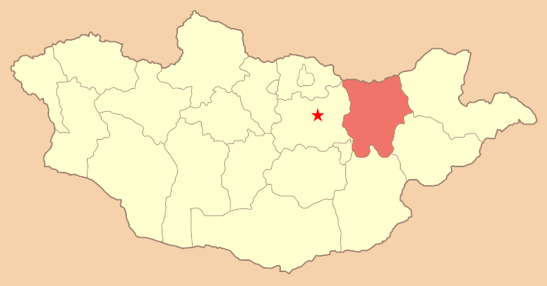
established = 1930
capital =Öndörkhaan
area = 80311
population = 66762
population_as_of = 2005
population_density = 0.83
timezone = UTC+8
area_code = +976 (0)156
code1_type = License plate
code1 = ХЭ_ (_ variable)
code2_type =ISO 3166-2 code
code2 = MN-039
website = http://gate1.pmis.gov.mn/khentii/Khentii ( _mn. Хэнтий) is one of the 21 aimags (provinces) of
Mongolia , located in the east of the country. Its capital isÖndörkhaan . The aimag is named after theKhentii Mountains .Geography
The aimag borders with
Russia in the north. The neighbouring aimags are Darkhan-Uul in the northwest, Töv in the west, Govisümber in the southwest, Dornogovi in the south, Sükhbaatar in the southeast, and Dornod in the east. The border to Töv is divided by the city ofBaganuur , an administrative exclave ofUlan Bator .The northwest of the aimag is covered by the eastern part of the
Khentii Mountains , towards the southeast the landscape changes into the eastern Mongolian steppe plains. The mountainBurkhan Khaldun in theKhan Khentii Strictly Protected Area is considered sacred, and assumed to be the birthplace ofGenghis Khan .South of Burkhan Khaldun the
Kherlen River originates, which crosses the south of the aimag in eastern direction after a detour through Töv. A little further east is the spring of theOnon River . TheBalj-Onon National Park is located in the northeast of the aimag.Administrative Subdivision
:* - Berkh including.:** - Bor-Öndör including.:*** - The aimag capital
Öndörkhaan including.References
Wikimedia Foundation. 2010.