- Dalälven
-
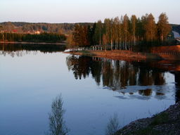
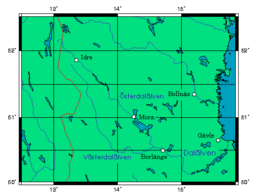
Dal River (Dalälven) River Country Sweden Mouth Gulf of Bothnia - elevation 0 m (0 ft) - coordinates 60°38′30″N 17°27′00″E / 60.64167°N 17.45°E Length 520 km (323 mi) [1] Basin 28,953.8 km2 (11,179 sq mi) [2] Discharge - average 379 m3/s (13,384 cu ft/s) [1] The Dal River (or Dalälven in Swedish) is a river in central Sweden that flows from the north of Dalarna and runs into the sea in northern Uppland; it is commonly considered to be the southern border of Norrland. The northern part is split into two rivers: Österdalälven and Västerdalälven. The two connect in Djurås. It is over 520 km long — the second longest river in Sweden, and has a hydropower potential of 1420 megawatts, of which 2/3 is utilized. The largest power plant is located at the Trängslet dam. Dalälven has been significant historically as a raft transport route.
References
- ^ a b "Dalälven" (in Swedish). Nationalencyklopedin. http://www.ne.se/dal%C3%A4lven. Retrieved 11 July 2010. (subscription required)
- ^ "Län och huvudavrinningsområden i Sverige" (in Swedish). SMHI. http://www.smhi.se/sgn0102/n0205/lan_haro_huvud.pdf. Retrieved 11 July 2010.
Categories:- Rivers of Sweden
- Dalarna
- Dalälven basin
- Sweden geography stubs
Wikimedia Foundation. 2010.


