- Guam Highway 1
Infobox road
country=Guam
route=1
highway_name=Marine Corps Drive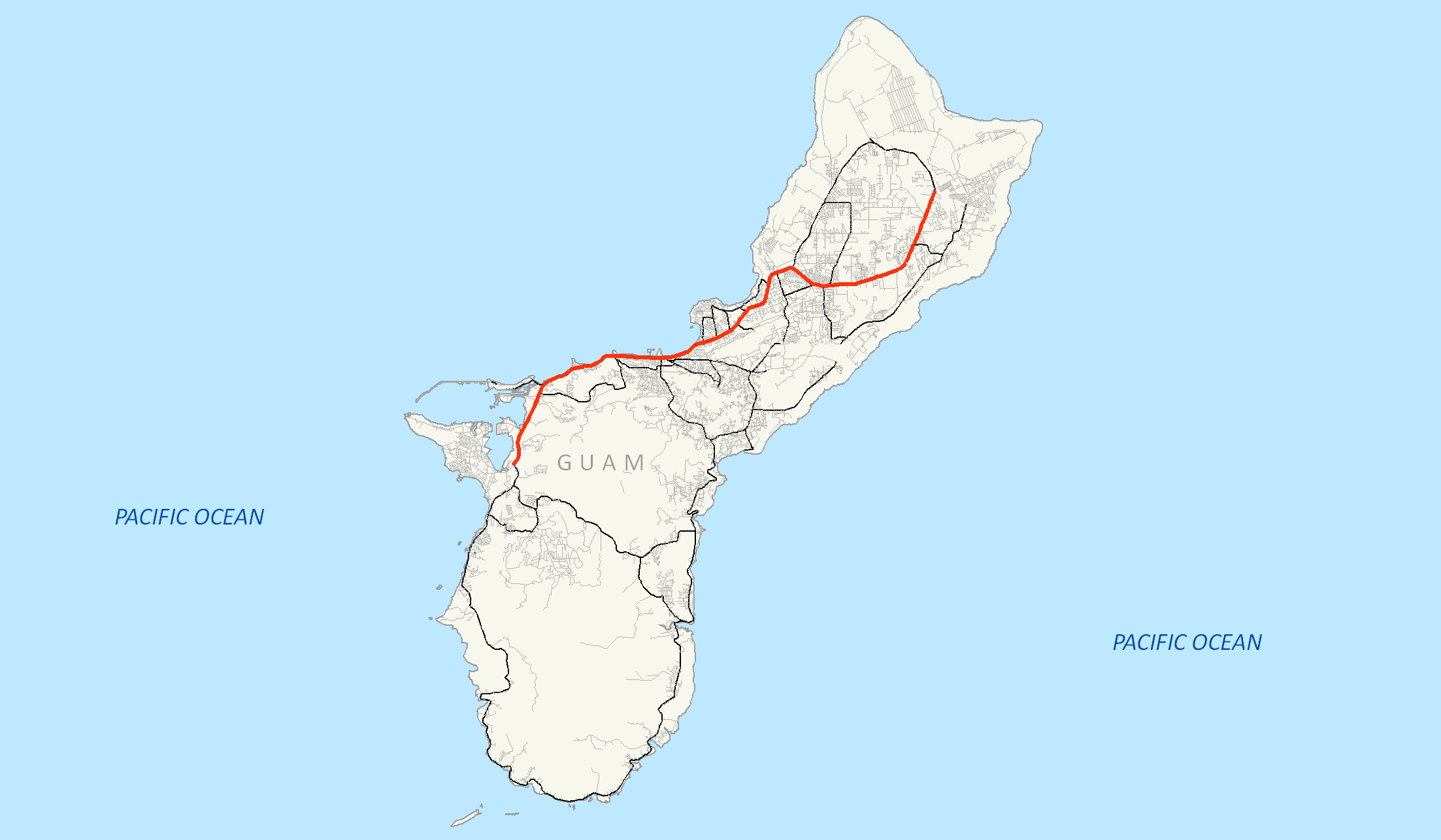
maint=Guam Department of Public Works
length_mi=21.04
length_round=2
length_ref=cite web | author= U.S. Census Bureau | title=2006 Second Edition TIGER/Line File | date=2006-01-01 | work=U.S. Census Bureau | url= http://www2.census.gov/geo/tiger/tiger2006se/GU/ | accessdate=2008-02-19 ]
direction_a=West
starting_terminus=Entrance Gate toNaval Base Guam
junction=Guam Highway 2A near Santa RitaGuam Highway 18 in PitiGuam Highway 6 in Piti
Guam Highway 6 near HagåtñaGuam Highway 4 in HagåtñaGuam Highway 8 in Mongmong-Toto-MaiteGuam Highway 14B in TamuningGuam Highway 16 in TamuningGuam Highway 3 in Dededo
direction_b=East
ending_terminus=GH 9A/Entrance Gate toAndersen Air Force Base
previous_type=Guam
previous_route=33
next_type=Guam
next_route=2Guam Highway 1 is one of the primary automobile routes in the
United States territory ofGuam . It runs in a southwest to northeast direction, from the main gate ofNaval Base Guam in the western community of Santa Rita in a general northeasterly direction to the main gate ofAndersen Air Force Base in the community of Yigo.Route description
Guam Highway 1 begins near the entrance gate to
Naval Base Guam , after a few hundred feet it has a junction withGuam Highway 2A before continuing on eastward. Known as Marine Corps Drive, the route then travels to the northeast through the town of Piti. After passing through Piti, the road runs inland from the shoreline before turning slightly to the east, now paralleling the coast, where it passes through the community of Asan. Soon, thereafter, the road cuts a path, due east, towards the Island's capital, Hagåtña where it passes through the northern edge of the city.After passing through the capital and the community of Mongmong, the road turns towards the northeast as it skirts to the west of
Antonio B. Won Pat International Airport on its way through the village of Tamuning. After the airport, the route runs inland from the shoreline as it cuts across the southern edges of Dededo and Yigo villages before reaching its terminus at Salisbury Junction, near the entrance gate toAndersen Air Force Base , where the road continues to the northwest asGuam Highway 9 .Like most major highways on Guam, a 35 mph (56 km/h) speed limit is posted throughout most of its length. In the past, Route 1 was one of the few roads to post a 45 mph (72 km/h) limit on lengths of less-developed roadway. However, as more of the area became developed, certain sections of the roads were posted with lower limits. Travelers heading north away from the developed areas are allowed a 45 mph (72 km/h) speed limit, however the southbound lanes on the same sections remain posted at 35 mph due to development on the western side of the road.cite news |first=John |last=Davis |title=One road, two speed limits? Better believe it. |url=http://www.kuam.com/news/25923.aspx |work=KUAM News |date=2008-01-03 |accessdate=2008-02-23 ]
History
The United States Military began to develop and construct roads on the island in the early 1940s. Some roads had existed prior to this, but improvements were beginning to take shape. Only one road, which encircled most of the island, had been graded. It was the primary route linking Agana (the name of the capital at the time) to Piti and Asan. This was the foundation for Marine Corps Drive. cite web|url=http://www.nps.gov/archive/wapa/indepth/extContent/cri/part2a.htm | title=War in the Pacific NHP: Cultural Resources Inventory | work=National Park Service | accessdate=2008-02-19]
Named Marine Corps Drive throughout its length, it was known as simply "Marine Drive" until the road was rededicated by Governor
Felix Perez Camacho in 2004.cite web|url=http://www.bobsoffice.org/bobinthenews/april2004/041304_4.html | title=Governor signs order to rename Marine Drive to "Marine Corps Drive" | work=Marissa Eusebio, KUAM News | accessdate=October 31 | accessyear=2006]Major intersections
Jctint
state=GU
location_special=Santa Rita
lspan=2
mile=0.00
road=Entrance toNaval Base Guam
notes=Western terminusJctint
state=GU
mile=0.05
road=Guam Highway 2A Jctint
state=GU
location_special=Piti
lspan=2
mile=2.72
road=Guam Highway 18 Jctint
state=GU
mile=2.82
road=Guam Highway 6 Jctint
state=GU
mile=6.00
location_special=Hagåtña
road=Guam Highway 6 Jctint
state=GU
mile=7.84
location_special=Mongmong-Toto-Maite
road=Guam Highway 8 Jctint
state=GU
mile=10.34
location_special=Tamuning
lspan=2
road=Guam Highway 14B Jctint
state=GU
mile=13.19
road=Guam Highway 16 Jctint
state=GU
mile=21.04
location_special=Yigo
road=Guam Highway 9
notes=Eastern terminus
Entrance toAndersen Air Force Base External links
[http://www.nps.gov/wapa/planyourvisit/index.htm War in the Pacific National Historic Park]
References
Wikimedia Foundation. 2010.