Mawddach Trail

Mawddach Trail
Mawddach trail
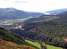
The Mawddach Trail follows the southern (closest to camera) bank of the Afon Mawddach

The Mawddach Trail (Welsh: Llwybr Mawddach) is a cycle path route, part of Lôn Las Cymru, which runs for some 8 miles (13 km) from Dolgellau (52°44′41″N 3°53′12″W / 52.7446°N 3.8866°W / 52.7446; -3.8866 (Mawddach Trail (eastern end))) to Morfa Mawddach railway station (52°42′27″N 4°01′53″W / 52.7076°N 4.0315°W / 52.7076; -4.0315 (Mawddach Trail (western end))), by Barmouth bridge on the Cambrian coast. It is maintained by the Snowdonia National Park and is popular with walkers and cyclists alike. It passes some estuarine areas that are important for water birds, and the RSPB Information Centre at Penmaenpool makes use of the old signal box as an observation centre overlooking the estuary.

The cycle route is a rail trail running along the former trackbed of the Ruabon to Barmouth branch line of the Great Western Railway. This line closed under the Beeching Axe in the 1960s.

External links

Coordinates: 52°44′25″N 3°58′09″W / 52.7404°N 3.9692°W / 52.7404; -3.9692


Wikimedia Foundation. 2010.

Игры ⚽ Нужен реферат?

Look at other dictionaries:

  • Mawddach — Goldwäscher im Waldgebiet Coed y BreninVorlage:Infobox Fluss/KARTE fehlt Daten …   Deutsch Wikipedia

  • River Mawddach — Afon Mawddach River Mawddach looking west to Barmouth Bay Mouth Barmouth Basin countries Wales The …   Wikipedia

  • Morfa Mawddach railway station — Morfa Mawddach Location Place …   Wikipedia

  • Ruabon to Barmouth Line — [v · d · …   Wikipedia

  • Barmouth Bridge — The Barmouth Bridge (Welsh: Pont Abermaw ) is a single track largely wooden railway viaduct that crosses the estuary of the Afon Mawddach river on the coast of Cardigan Bay between Morfa Mawddach and Barmouth in Gwynedd, Wales. A footbridge is… …   Wikipedia

  • Dolgellau — Coordinates: 52°44′N 3°53′W / 52.74°N 3.88°W / 52.74; 3.88 …   Wikipedia

  • Barmouth — mit Eisenbahnbrücke blaue Stunde an der Mündung des Mawddach Barmouth Hafenkai und …   Deutsch Wikipedia

  • Arthog — (officially Capel Arthog Melville Richards, Welsh Administrative and Territorial Units , 1969, ISBN 0900768088] ) is a village in Gwynedd, Wales. It is located on the A493 road, approximately eight miles west of Dolgellau.It is well known for its …   Wikipedia

  • List of rail trails — This is a list of rail trails around the world. Rail trails are former railway lines that have been converted to paths designed for pedestrian, bicycle, skating, equestrian, and/or light motorized traffic. Most are multiuse trails offering at… …   Wikipedia

  • Barmouth — infobox UK place country=Wales welsh name=Abermaw constituency welsh assembly= map type=Abermaw official name=Barmouth (Abermaw) latitude=52.722 longitude= 4.055 unitary wales=Gwynedd lieutenancy wales=Gwynedd constituency westminster=Meirionnydd …   Wikipedia

Share the article and excerpts

Direct link
Do a right-click on the link above
and select “Copy Link”