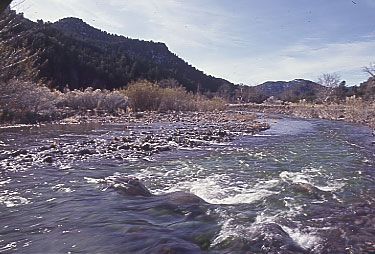
- Blue River (Arizona)
Infobox_River
river_name = Blue River

image_size =
caption =
origin =
mouth =
basin_countries =United States
length_km =
length =
elevation_m =
elevation =
mouth_elevation_m =
mouth_elevation =
discharge_m3/s =
discharge =
watershed_km2 =
watershed =The Blue River is a 24-mile-long stream that runs through the
Apache-Sitgreaves National Forest inArizona . It arises near Alpine and flows south into theSan Francisco River just upstream from Clifton. The Blue River varies in altitude from 6400 to 4000 feet. Although only a good snow melt and the accompanying runoff provide the Blue River with its water flow, anglers may find some trout in the upper reaches. Campers may set up at two established sites (Upper Blue or Blue Crossing) or at the primitive grounds at the end of FR 281.Boating Facility Features
* Boat Trailer Parking
* Tables
* Drinking Water
* Restrooms
* Trailer Spaces
*Camping Allowed
* Gravel Access
* Trail AccessFish Species
GPS Coordinates
* Latitude: 33°29'35.90"N
* Longitude: 109°12'44.43"WExternal links
* [http://gorp.away.com/gorp/resource/us_national_forest/az/pad_apac.htm#blue GORP Article on the Blue River]
* [http://www.azgfd.gov/outdoor_recreation/BoatingLocationsMap.shtml Arizona Boating Locations Facilities Map]
* [http://www.azgfd.gov/h_f/FishingLocationsMap.shtml Arizona Fishing Locations Map]
* [http://www.azgfd.gov/h_f/where_fish.shtml Where to Fish in Arizona Species Information]References
*Citation |first=Information and Education Division|title=Arizona Fishin' Holes|place=Phoenix, AZ|publisher=
Arizona Game and Fish Department |year=2007
Wikimedia Foundation. 2010.
