- Dungeness Spit
-
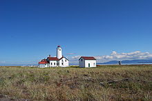 The New Dungeness Lighthouse located at the end of Dungeness Spit.
Dungeness Spit is a 5.5-mile (8.9 km) long sand spit jutting out from the northern edge of the Olympic Peninsula in northeastern Clallam County, Washington, into the Strait of Juan de Fuca. It protects Dungeness Bay.[1] The Dungeness Spit is entirely within the Dungeness National Wildlife Refuge and home of the Dungeness Lighthouse. It is the longest natural sand spit in the United States. Its land area, according to the United States Census Bureau, is 1,271,454 square meters (0.4909 sq mi, or 314.18 acres). The lighthouse once was run by USCG, but since an automatic light was installed, it has been run by the "New Dungeness Lighthouse Organization".
It was first found by Europeans during the Spanish 1790 Quimper expedition.
The name "Dungeness" refers to the Dungeness headland in England. It was given by George Vancouver in 1792, who wrote: The low sandy point of land, which from its great resemblance to Dungeness in ths British Channel, I called New Dungeness.[2]
In December 2001 a heavy winter storm forced water over the spit. The next morning the spit was broken in three places, and vehicles supplying the lighthouse were not able to traverse the spit for about a month.
See also
References
- ^ U.S. Geological Survey Geographic Names Information System: Dungeness Bay
- ^ Phillips, James W. (1971). Washington State Place Names. University of Washington Press. ISBN 0-295-95158-3.
External links
- Dungeness Spit: Block 2000, Census Tract 9816, Clallam County, Washington United States Census Bureau
- US Fish & Wildlife - Dungeness NWR
- New Dungeness Lighthouse
Coordinates: 48°10′07″N 123°08′22″W / 48.168604°N 123.1394°W
Categories:- Headlands of Washington (state)
- Landforms of Clallam County, Washington
- Spits of the United States

Wikimedia Foundation. 2010.