- Bécancour River
Geobox River
name = Bécancour River
native_name = Rivière Bécancour
other_name =
other_name1 =
image_size =
image_caption =
country = flagicon|CanadaCanada
country1 =
state = flagicon|QuebecQuebec
state1 =
region =Chaudière-Appalaches
region1 =Centre-du-Québec
district =
district1 =
city =
city1 =
city2 =
city3 =
city4 =
city5 =
city6 =
city7 =
city8 =
city9 =
city10 =
length = 210
watershed = 2607
discharge_location =Saint Lawrence River
discharge_average = 62
discharge_max =
discharge_min =
discharge1_location =
discharge1_average =
source_name =Lac Bécancour
source_location = Thetford Mines
source_district =
source_region =Chaudière-Appalaches
state_type = Province
source_state =Quebec
source_country =Canada
source_lat_d = 46
source_lat_m = 04
source_lat_s = 10
source_lat_NS = N
source_long_d = 71
source_long_m = 14
source_long_s = 39
source_long_EW = W
source_elevation =
source_length =
mouth_name =
mouth_location = Bécancour
mouth_district =
mouth_region =Centre-du-Québec
mouth_state =Quebec
mouth_country =Canada
mouth_lat_d = 46
mouth_lat_m = 22
mouth_lat_s = 20
mouth_lat_NS = N
mouth_long_d = 72
mouth_long_m = 26
mouth_long_s = 47
mouth_long_EW = W
mouth_elevation =
tributary_left =
tributary_left1 =
tributary_right =
tributary_right1 =
free_name =
free_value =
map_size =
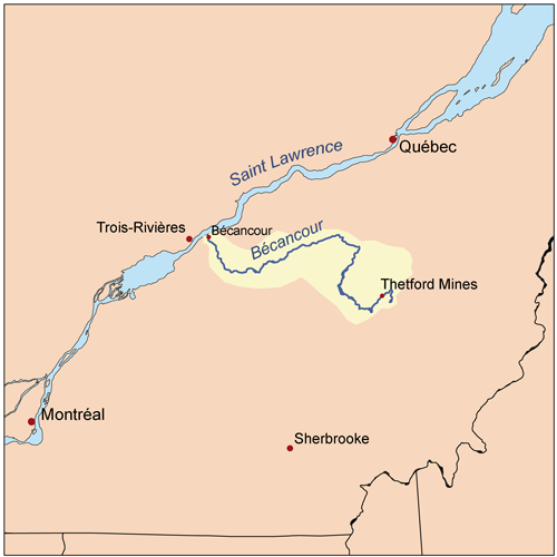
map_caption =The Bécancour River is a river in the Canadian province of
Quebec .The Bécancour takes its source from the lake of the same name in the town of Thetford Mines, in the
Chaudière-Appalaches region. It flows west intoLake William at Saint-Ferdinand, changes course northwards towards Inverness, turning westward there and continuing to flow west across theCentre-du-Québec region for most of its length. The river takes a turn northwestward at Saint-Wenceslas, finally emptying into theSaint Lawrence River near the heart of the city of Bécancour [ [http://www.grobec.org/b_geographie.php GROBEC - Géographie du bassin de la rivière Bécancour] . Accessed 28-Aug-2007.] .Major tributaries
* Au Pin River
* Palmer River
* Noire River
* Bourbon River
* Blanche River (Saint-Rosaire)
* Blanche River (Saint-Wenceslas)References
Wikimedia Foundation. 2010.