- Peñalara Nature Reserve
Infobox protected area
name = Peñalara Nature Reserve
iucn_category =
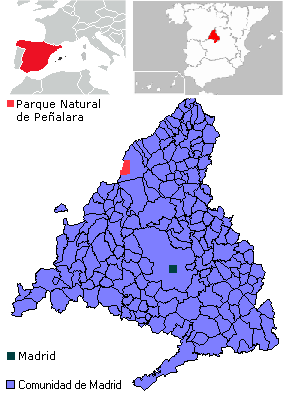
caption = Mapa del Parque Natural de Peñalara.
locator_x = -9999
locator_y = -9999
location =Community of Madrid (Spain )
nearest_city =Rascafría
coordenadas = coor dm|40|50|N|3|57|W
area = 7.68 km²
ecosistemas = Forests, meadows, stony terrain, and mountain lakes
established =June 15 ,1990
visitation_num = 133,000
visitation_year= 2006
governing_body = Community of Madrid
web = [http://parquesnaturales.consumer.es/documentos/madrid/cumbre_penalara/index.php parquesnaturales.consumer.es]The Peñalara's Summit, Cirques and Lakes Nature Reserve (in Spanish: "Parque Natural de la Cumbre, Circo y Lagunas de Peñalara") is a protected area of 7.68 km² in the central zone of the
Sierra de Guadarrama (part of the mountainous axis called the Central System) inSpain . It is located to the south-east ofPeñalara Peak inRascafría district and northwest of theCommunity of Madrid . The reserve shelters Peñalara's summit, the highest peak of the mountain system; three smallcirque s; two moraines; and several glaciallake s. TheCommunity of Madrid declared the area a nature reserve in June 1990.The zones of lowest altitude hold
white pine forests and grasslands. Bushes grow higher up in the mountains, which are predominately composed of alpine meadows and rocky areas. The park is home to theblack vulture and theimperial eagle , and also many small mammals and amphibians.The park is accessible from "Puerto de Cotos", the region's center of tourism. Especially popular on the holidays, the reserve provides a venue for
hiking ,mountain climbing , andskiing .Geography
Peñalara Nature Reserve is located in the zone of highest elevation on the southeastern slope of Peñalara Peak, with its 2.428 kilometers the highest in the
Sierra de Guadarrama , in the high part of Lozoya Valley, and in the district ofRascafría . It covers a rough rectangle of 7.68 square kilometers. The coordinates of the reserve's central zone are 40º 50' N 3º 57' W.In the northern zone are two projecting cliffs difficult to reach; the northernmost is Bird Cliff, with a height of 2.334 kilometers. Close by and to the south is the Cliff of Carnations, which being 2.388 kilometers above sea level is the second-highest peak in the
Sierra de Guadarrama . No other elevations are so prominent. To the south is Peñalara peak, distinguished by ageodesic vertex of the first order that indicates its height of 2.285 kilometers. The 2.271 km Two Sisters Mountain marks the southeastern limit of the park. Besides these peaks, other highlights include Cheese Boulder, a 2.032 km peak to the southeast of the Younger Sister, midway between Puerto de Cotos and the cirque of Peñalara.The peaks of the park, ordered from north to south, are the following:
*Bird Cliff (2.334 km)
*Cliff of Carnations (2.388 km)
*Peñalara Peak (2.428 km)
*Older Sister Mountain (2.285 km)
*Younger Sister Mountain (2.271 km)
*Cheese Boulder (2.032 km)One of the most interesting elements of the reserve is the Peñalara cirque, created by a glaciar. It is located between the summit of Peñalara and the Younger Sister, on the eastern slope of both peaks. The base of the cirque has an altitude of 2 to 2.05 km, and its sides rise from this elevation to 2.2 and 2.4 km. There are also three other cirques of lesser size and importance. One of these is the cirque of Pepe Hernando, located some 500 m to the south of the Lake of Carnations. Its size is a quarter of Peñalara's, and its base rises to approximately 1.9 km. The others are the cirques of the Regajo de la Pedriza y Brezal. Each has a
moraine at its lower part, a rocky zone with a relatively gentle slope that was produced by the track of an ancientglacier . Besides cirques and moraines, there exists a series of walls with elevations greater than 200 m aligned north to south, extending north and south from the principle cirque.Hydrography
There are some twenty small glacial lakes in the park. All are located to the east of the large walls in a relatively level zone of elevation 2.2 - 2 km. One of the largest is Bird Lake to the northeast of Bird Cliff. A half kilometer to the south is the Lake of Carnations, a small lagoon between the Cliff of Carnations and the eastern slope of Peñalara Peak. In the bed of Peñalara cirque, further to the south, is the circular Peñalara Great Lake, the most extensive in the reserve. It is the most popular with visitors. Approximately .6 km to its southeast is Chica Lagoon, the most distant lake of the cirque: a small and seldom-visited lagoon that commands an impressive view of the Older Sister Mountain, the Peñalara cirque, and Peñalara Peak. All the lakes remain frozen from September until about March.
During the wet seasons (fall and spring), a series of
arroyo s flow from the major lakes and often form cascades, which add to the landscape's beauty. Bird Arroyo originates from Bird Lake, and the arroyo of Peñalara's lagoon originates from the Great Lake. All these streams run eastward and belong to the western region of theLozoya River basin.Geology
The high relief of the reserve is due to the collision between the
tectonic plates corresponding to the North and South Subplateaus. Both form part of the Central Plateau. In the Middle Paleozoic (360 to 290mya (unit) ), an initial substrate of ancientgranite s andsediment s began to fold and metamorphose, creating thegneiss es.During the Late
Paleozoic (290 to 250 mya), those materials began to fracture. Masses ofmagma began rising to the surface, and in this way the granites were formed. The final phase of this era produced a general elevation of the Peñalaramassif .From the end of the Paleozoic and during the
Mesozoic (250 to 65 mya), the processes oferosion began to wear down the contours of the land. In this last period occurred a monumental departure from the ocean, which left subaquatic zones exposed on the surface (prior to this, it is likely that thesierra was not more than anislet raised slightly above the sea) and formed sinks of sediment that covered the plains with sediment and would give them their later calcareous character.In the
Cenozoic orTertiary (65 to 1.8 mya), the processes that raised the Peñalara massif and divided it into the blocks we find today began to work again. Erosion of the rocky massif filled the basins with sediment. Glacial action in theQuaternary (1.8 mya to present) finished shaping the Peñalara cirque and the walls of the mountainous axis. The cirques were covered by a mantle of ice up to 300 m thick [ [http://www.parquenaturalpenalara.org/parque-natural/general/valores-pnp.html Parque Natural de Peñalara - Valores generales] ] . Later, the confluence of the rivers gave the final touch to the landscape. The dominant rock in the park isgranite , which is very hard and erosion-resistant.Flora and fauna
The flora and fauna of Peñalara Natural Reserve are exclusively in the mountains. The cold climate, the strong wind, and the abundant snow during most of the year are the reasons why forests only grow at low altitudes and the fauna is composed of small animals.
Flora
The dominant vegetation is a
matorral of broom and jabino, which alternates with meadows ofNardus stricta in wetter areas like the cirque basins. Less plentiful but of equal interest are the swamp blueberries of the Peñalara plains. Other, less common types of matorral are composed of true heath andjuniper . Under the elevation 2 km grow tight-knitted forests ofwhite pine . These are the only species of tree in the reserve. Thickets offern grow in the forests, though not abundantly. Several brightly-colored flowers grow high in the mountains in spring and simmer. The reserve contains 343 species ofvascular plant s and 200 species oflichen . About half thetaxon s of vascular plants are considered rare, endemic, or threatened. Of those, fifty have populations so reduced they require maximum protection.Fauna
The animals in the reserve are small in size:
amphibian s in the lakes, variousbird s, and smallmammal s. Ten species of amphibian are recorded, of which six are included in the National Catalogue of Threatened Species. 79 of the 97 bird species are also protected. [ [http://www.parquenaturalpenalara.org/parque-natural/general/valores-pnp.html Parque Natural de Peñalara - Valores generales] ] . The most common amphibian is thesalamander ; the most common birds are the hedge sparrow, the gray callaba, the pechiazul, thecrag martin , the alpine chough, theimperial eagle , and theblack vulture . The snow vole lives in the matorral and the rock and mountain lizards among the rocks. Among thebutterflies are the Parnassius apollo, the Plebicula ni ecensis, and the Hyphoraia dejeani. The mammals includesquirrel s,rabbit s, andbadger s. The ten species of amphibians in the reserve, which outnumber all the species inEngland or northernEurope , live in the wet zones.Climate
Peñalara Nature Reserve has a
mountain climate characterized by very cold winters and mild summers.Precipitation is plentiful. Snow falls in winter and part of the spring. The area's cold temperatures generally cause rain to freeze into snow from the end of November to the middle of May. In the highest zones, snow may last until July. The Peñalara lakes freeze in December and thaw in March. A meteorological phenomenon of the winter is the freezing fog, or the fog of ice, which covers vegetation in ice when the temperature is less than 0°C.The average temperature is about 6 or 7°C. It reaches a maximum of 22°C in summer and a minimum of -14°C in winter. December through February, the temperature does not rise above 0°C, and the snow cap grows larger. Storms are frequent in spring, summer, and to a lesser degree, autumn. The wind is intense in the mountains, especially when the pressure is low, and a thick fog is common throughout the year. The wind at average strength comes from the northeast. Average
relative humidity is about 75%. Adverse weather phenomena such as tornadoes, hurricanes, and earthquakes are rare.Climate of
Puerto de Cotos (1.830 km)History
[

Francisco Giner de los Ríos , pedagogue of the Institución Libre de Enseñanza committed to the conservation of the Peñalara environs.]During the 1920s, various intellectuals from the Institución Libre de Enseñanza (Free Teaching Institute) showed the great ecological importance of the
Sierra de Guadarrama . They planned the creation of aGuadarrama National Park to protect the high zones of the sierra. Their project was never carried into effect, due to changes in government and theSpanish Civil War .The great scientific interest in the region throughout the 1920s prompted its designation in 1930 as a Natural Area of National Interest to protect it from outside attack.
In the 1980s began a project to protect the slopes of Peñalara Peak, including the cirque and the lakes. On
June 15 ,1990 , theCommunity of Madrid declared the zone a Natural Park of the Peak, Cirque, and Lakes of Peñalara by the law 6/1990, granting the region autonomous government. From 1998 to the beginning of the twenty-first century, the ancientValcotos ski resort that occupied a large part of the protected area was dismantled. The ski lifts were removed and the slopes repopulated with white pine and old trail. This pioneering action also brought about an improvement of the facilities atPuerto de Cotos .In the beginning of the twenty-first century, the Community of Madrid together with
Castilla y León declared that a large portion of the sierra would form Guadarrama National Park. However, as at 2008 this proposal has yet to be formalised.Buildings of Interest
The Monastery of Santa María de El Paular, built toward the end of the fourteenth century, is located only 8 km northeast of Peñalara Nature Reserve, in the district of
Rascafría and in the center ofLozoya Valley. Its construction was ordered by King Enrique II of Castille. The building was declared a national monument in 1876. Notable are itscloister s, the church atrium, and theretable s. The beauty of the monastery is framed by the surrounding mountains.Tourism
Since the fourteenth century, Peñalara Nature Reserve has drawn hundreds of sightseers with its magnificent views and landscape. Today, the park is visited by an average of 130,000 people every year.
Puerto de Cotos , a mountain pass at the reserve's southern boundary connecting theCommunity of Madrid and the province of Segovia, is the center of tourism and point of departure for all routes crossing the reserve. From the same place runs the C-9 line of theCercanías Madrid , which leaves fromCercedilla and is known as the Guadarrama rail. This transportation route sees massive use during the festive days. There is also a bus line running through the mountain pass. The major parking lot in the tourism center accommodates cars and buses. An information building at Puerto de Cotos dispenses maps of trails and safety rules. The tourism center also holds a restaurant, the headquarters of the Spanish Alpine Club, a mountain-climbing school, and a sled rental. In winter the large esplanade of Puerto de Cotos becomes a sledding track.At the foot of the Older Sister, some 300 m south of Peñalara Great Lake and 2.075 km high, is the obsolete Zabala mountain shelter, which is now used only for storage of maintenance supplies. The hotels and lodges nearest to Peñalara Nature Reserve are in
Puerto de Navacerrada and the town ofRascafría .The flood of sightseers during the festival days is intense. The most popular activity in the park is hiking. Extra precautions are needed in winter, when the bad weather and thick snow and ice make for hard travel and easy disorientation.
Another popular activity is mountain climbing, which can be done in authorized areas on the Peñalara cirque. The mountain-climbing sectors are Two Sisters, Cosaco, Placas Duro, Teresa, Trapecio, and Zabala. [ [http://www.parquenaturalpenalara.org/uso-publico/escalada/croquis.html Sectores y vías de escalada del parque] ] . In winter one can also ski cross-country on the broad paths and areas near Puerto de Cotos, which are vestiges of the old Valcotos ski resort. This is particularly popular with Madrid and Segovia residents.
How to get there
Panoramic Views
Cartography
*Map "Guide to Sierra de Guadarrama 1:50.000", edited by "I.G.N.". ISBN 84-234-3412-0
*Map "Guadarrama sightseeing 1:25.000", edited by "Alpine publishing". ISBN 84-8090-159-4
*Map "Sightseeing at La Pedriza 1:25.000", edited by "Alpine publishing". ISBN 84-8090-160-8
*Map "Sierra de Guadarrama 1:50.000", edited by "The Green Store". ISBN 84-611-3107-XReferences
Notes
Bibliography
*Blázquez, Heras, De Mingo-Sancho, Rubio, Segura, Sintes y Barbadillo (1996). "Valle Alto del Lozoya". CATARATA Books. ISBN 84-8198-154-0
*Fidalgo García, Pablo & Martín Espinosa, Agustín (2005). "Atlas Estadístico de la Comunidad de Madrid 2005". Instituto de Estadística of the Comunnity of Madrid. ISBN 84-451-2786-1
*Pliego Vega, Domingo (1999). "Excursiones por el Parque Natural de Peñalara". Desnivel Editions. ISBN 84-899-6923-x
*Pliego Vega, Domingo (2002). "Excursiones en el macizo de Peñalara". Ediciones Desnivel. ISBN 84-957-6059-2
*VV.AA. (2003). "Peñalara. Revista ilustrada de alpinismo. Facsímil tomo II". Desnivel Editions. ISBN 84-451-2443-9See also
*
Sierra de Guadarrama
*Guadarrama National Park
*Peñalara External links
* [http://penalara.sierranorte.com/ esOfficial website of the Peñalara Nature Reserve]
* [http://maps.google.es/maps?q=Guadarrama&hl=es&om=1&t=k&ie=UTF8&z=13&ll=40.846022,-3.954563&spn=0.059734,0.171661&iwloc=A Image of the Peñalara Nature Reserve in Google Maps]
Wikimedia Foundation. 2010.