- Mount Shaw
-
Mount Shaw 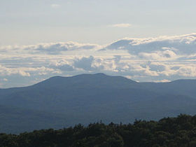
Elevation 911 m (2,989 ft) Prominence 710 m (2,329 ft) Listing Location Location Carroll County, New Hampshire, USA Range Ossipee Mountains Coordinates 43°44.63′N 71°16.45′W / 43.74383°N 71.27417°WCoordinates: 43°44.63′N 71°16.45′W / 43.74383°N 71.27417°W Topo map USGS Melvin Village Mount Shaw is a mountain located within the Castle in the Clouds estate in Carroll County, New Hampshire. With a summit elevation of 2,990 feet (911 m) it is the highest of the Ossipee Mountains.
Although of only moderate elevation, the isolation of the Ossipee Mountains gives Shaw 2,330 ft (710 m) of prominence above the low ground separating it from the White Mountains, making it one of twelve peaks in New Hampshire with a prominence over 2,000 ft (610 m).[1]
The north and southeast sides of Mt. Shaw drain into the Lovell and Dan Hole rivers, thence into the Ossipee River, Saco River and the Gulf of Maine. The southwest side drains into the Melvin River which flows into Lake Winnipesaukee, thence into the Winnipesaukee River, Merrimack River, and into the Gulf of Maine in Massachusetts.
See also
External links
Categories:- Mountains of New Hampshire
- Landforms of Carroll County, New Hampshire
- New Hampshire geography stubs

![[1]](http://www.peaklist.org/USmaps/newenglandsummits.gif)
Wikimedia Foundation. 2010.