Little Cumberland Island Light
- Little Cumberland Island Light
Infobox Lighthouse
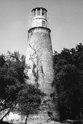
caption = Little Cumberland Island Lighthouse
location = Little Cumberland Island, Georgia
coordinates = coord|30.974|N|81.4168|W
yearbuilt = 1838
yearlit = 1838
automated =
yeardeactivated = 1915
foundation = Brick
construction = Brick
shape =
elevation =
height = 60 ft
currentlens = Third order Fresnel lens (removed)
lens = 14 Lamps (removed)
intensity =
range =
characteristic = Fixed white
Little Cumberland Island Lighthouse is a lighthouse in Georgia,
United States, on the north end of Little Cumberland Island, Georgia
History
Little Cumberland Island Lighthouse was built in 1838. It had fourteen lamps generating a fixed light, which distinguished it from the older tower to the south that had a revolving light. In 1874, a brick wall was built around the lighthouse to protect it from the encroaching sea. The lighthouse was in service until 1915 when it was deactivated. The keeper's house and all other light station buildings were demolished in 1968, but the tower remained. The tower was renovated in 1994 to 1998. A large dune protects the lighthouse from the ocean, but as a result the tower is now barely visible from the water. Little Cumberland Island is privately owned and is not open to the public.
The lighthouse is on the National Register of Historic Places, No. 89001407. It was designated on August 8 1989. [ [http://nationalregisterofhistoricplaces.com/ga/Camden/state.html National Register of Historic Places] ]
Less than 100 yards from the lighthouse is the grave of a sailor named Charles Farnum, who drowned in St. Andrew's Sound off of the coast of the island.
References
Wikimedia Foundation.
2010.
Look at other dictionaries:
Cumberland Head Light — Cumberland Head Lighthouse Location Cumberland Bay on Lake Champlain in New York Coordinates … Wikipedia
Cockspur Island Light — from the east, not in service Location Chatham County, Georgia, Savannah River, at Lazaretto Creek Coordinates … Wikipedia
North Brother Island Light — Location North Brother Island, New York Harbor Coordinates … Wikipedia
Amelia Island Light — Infobox Lighthouse caption = Amelia Island lighthouse (from U.S. Coast Guard archives) location = north end of Amelia Island at the mouth of the St. Mary s River coordinates = coord|30|40|23.46|N|81|26|32.8|W|type:landmark yearlit = 1838… … Wikipedia
Coney Island Light — Norton s Point Light Location Sea Gate, Brooklyn, New York City Coordinates … Wikipedia
Crossover Island Light — Location Crossover Island in the St. Lawrence River Year first constructed 1848 Year first lit 1882 Deactivated 1941 Foundation Stone Molehead Construction … Wikipedia
Old Harbor Light (Savannah, Georgia) — Savannah Harbor Rear Range Light Old Harbor Light in Emmett Park Location Emmett Park, Savannah, Georgia, USA Coordinates … Wikipedia
Esopus Meadows Light — 2000 Location West side of Hudson river Year first constructed 1839 Year first lit 1872 (current tower) Automated 1965 Deactivated 19652003 Foundation Granite pier on piles … Wikipedia
Coxsackie Light — Coxsackie Lighthouse Location Hudson River at Coxsackie, New York Coordinates 42°22′47″N … Wikipedia
Danskammer Point Light — Danskammer Point Lighthouse Year first constructed 1885 Markings / pattern White wooden tower Height 31 ft (9.4 m) Fog signal Bell struck every 20 seconds ARLHS number USA 1188 [1] USCG number 319 … Wikipedia