- Somerset Island and Fort Ross
Infobox Islands
name = Somerset Island
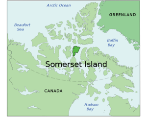
image caption = Somerset Island, Nunavut, Canada.
image size =
locator
map_custom =
native name =
native name link = Inuktikut
nickname =
location =Northern Canada
coordinates = coord|73|15|N|93|30|W|display=inline,title
archipelago =Canadian Arctic Archipelago
total islands =
major islands =
area = convert|24786|km2|sqmi|abbr=on
rank = 46th
highest mount =
elevation =
country = Canada
country admin divisions title = Territory
country admin divisions = flag|Nunavut
country largest city =Iqaluit
country largest city population = 6,184
country leader title =
country leader name =
population = Uninhabited
population as of =
density =
ethnic groups =Inuit
additional info =A member of the
Canadian Arctic Archipelago , Somerset Island is a large island across the 2km wideBellot Strait from theBoothia Peninsula in theQikiqtaaluk Region ofNunavut ,Canada . It has an area of 9,570 square miles (24,786 km²), making it the 45th largest island in the world and Canada's twelfth largest island. It is uninhabited.Due to the ruins, the wildlife and its easy access from Resolute, the northern coast of the island has become a popular
tourist destination .Around
1000 AD , the north coast of Somerset Island was inhabited by the Thule people, as evidenced bywhale bones, tunnels and stone ruins. In late 1848,James Clark Ross , commanding two ships, landed at Port Leopold on the northeast coast to winter. In April the following year, he launched an exploration of the island bysled ge.In 1937, the Fort Ross trading post (Coord|72|0|34|N|94|14|8|W|type:landmark) was established by the
Hudson's Bay Company at the southeastern end of the island. Only eleven years later, however, it was closed, as the severe ice conditions rendered it uneconomical and difficult to access. This left the island uninhabited. The former store and manager's house are still used as shelters byInuit caribou hunters from Taloyoak.In the summer of
2006 , CBC'sThe National visited Fort Ross in their travels on the Coast Guard icebreaker Louis S. St-Laurent in a special series focused onclimate change .cite news
url=http://www.cbc.ca/news/background/northwest-passage/communities.html
title=Northwest Passage: "The National" visits Canada's North
publisher=CBC News
date=2006-10-27
accessdate=2008-08-14
quote= [http://www.webcitation.org/query?url=http%3A%2F%2Fwww.cbc.ca%2Fnews%2Fbackground%2Fnorthwest-passage%2Fcommunities.html&date=2008-08-14 mirror] ]References
Further reading
* Berkhout, A. W. J., and L. W. Sobczak. "A Preliminary Investigation of Gravity Observations in the Somerset and Prince of Wales Islands, Arctic Canada, with Map". Gravity map series of the Dominion Observatory, no. 81. Ottawa: Canada Dept. of Energy, Mines and Resources, Observatories Branch, 1967.
* Canada. "Migratory Bird Population Surveys in the District of Keewatin and omeret Island, 1976" - AIPP PRELIMINARY REPORT 1977. 1978.
* Canadian Oceanographic Data Centre. "Stanwell-Fletcher Lake, Somerset Island, N.W.T". 1965-1966 CODC References: 07-65-002, 07-66-002. Ottawa: Queen's Printer, 1968.
*
* Geological Survey of Canada, J. F. Sweeney, H. R. Balkwill, R. Franklin, U. Mayr, P. McGrath, E. Snow, L. W. Sobczak, and R. T. Wetmiller. "North American Continent - Ocean Transects Programme, Corridor G, Somerset Island to Canada Basin". Open file (Geological Survey of Canada), 1093. 1984.
*
* Savelle, James M. "Cultural and Natural Formation Processes of a Historic Inuit Snow Dwelling Site, Somerset Island, Arctic Canada". American Antiquity, Vol. 49, No.3. 1984.
* Sekerek, A. D., D. Thomson, H. Bain, and J. Acreman. "Summer Surveys of the Marine Ecology of Creswell Bay, Somerset Island, and Assistance Bay, Cornwallis Island, N.W.T". 1975. Polar Gas environmental program. Toronto: LGL Limited, 1976.
* VanStone, James W., James E. Anderson, and C. F. Merbs. "An Archaeological Collection from Somerset Island and Boothia Peninsula, N.W.T". Toronto, 1962.External links
* [http://www.cbc.ca/news/background/northwest-passage/communities.html CBC.ca In Depth: Northwest Passage]

Wikimedia Foundation. 2010.