- Clastic dike
-
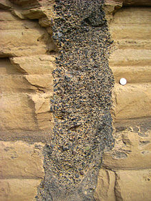
A clastic dike is a seam of sedimentary material that fills a crack in and cuts across sedimentary strata. Clastic dikes form rapidly by fluidized injection (mobilization of pressurized pore fluids) or passively by water, wind, and gravity (sediment swept into open cracks). Diagenesis may play a role in the formation of some dikes.[1] Clastic dikes are commonly vertical or near-vertical. Centimetre-scale widths are common, but thicknesses range from millimetres to metres. Length is usually many times width.
Clastic dikes are found in sedimentary basin deposits worldwide. Formal geologic reports of clastic dikes began to emerge in the early 19th century.[2][3][4][5][6][7]
Terms synonymous with clastic dike include: clastic intrusion, fissure fill, soft-sediment deformation, fluid escape structure, seismite, injectite, liquefaction feature, neptunian dike, paleoseismic indicator, pseudo ice wedge cast, sedimentary insertion, sheeted clastic dike, synsedimentary filling, tension fracture, and tempestite.
Environments of formation
Clastic dike environments include:
- Clastic dikes associated with earthquakes -
- An incredible variety of dikes is found in the geologic record. However, clastic dikes are typically produced by seismic disturbance and liquefaction of high water content sediments. Examples of this type are many.[8][9][10] Clastic dikes are paleoseismic indicators in certain geologic settings.[11][12] Several qualitative, field-based systems have been developed to help distinguish seismites[13] from soft sediment deformation features [14][15] formed by non-seismic processes.[16][17][18][19][20][21][22]
- Results from analytical modeling of clastic dike injection in soft Pleistocene-age rocks of the Ami'az Plain, Israel[23] indicate propagation occurred at a rate of approximately 4 to 65 m/sec at driving pressures of 1-2 MPa. Emplacement duration (<2 sec) appears similar to the speed with which acoustic energy (pressure waves) moves through young, partially-lithified sedimentary rock.
- Clastic dikes associated with debris flows -
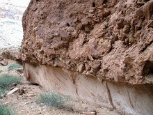
- Sandstone dikes formed by downward injection are found along Black Dragon wash upstream of the famous petroglyphs area, San Rafael Swell, UT.
- Clastic dikes associated with impact craters -
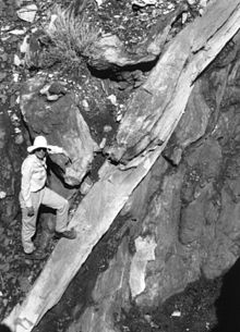 Clastic dike exposed on the east flank of the central peak of Upheaval Dome, Canyonlands, UT. Sandstone dike was injected downsection from the White Rim Sandstone into the Organ Rock Shale during the earliest part of the impact crater excavation stage. The dike is made of cataclastically broken sand grains derived from the White Rim Sandstone. The slightly overturned Organ Rock beds dip steeply to the left and their tops face toward the right. The White Rim Sandstone, folded to vertical, lies just off the photo to the right. View is to the north. P.W. Huntoon Collection.
- Sandstone dikes with cataclastically deformed sand grains, sourced in the Permian White Rim Sandstone, are found within Upheaval Dome, Canyonlands National Park, Utah,[24][25][26][27][28] at Roberts Rift,[29] and elsewhere.[30][31]
- Clastic dikes associated with salt domes -
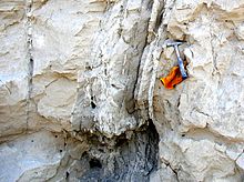
- Clastic dike swarms associated with salt dome diapirism is reported from the Dead Sea region.[32][33]
- Clastic dikes associated with glaciers -
- Sand injection features are reported to have formed under heavy loads and confining pressures beneath grounding glacial ice.[34][35][36][37][38][39][40][41][42][43][44][45][46][47]
- Clastic dikes in resistant bedrock -
- Though unusual, a significant number of reports describe sedimentary material intruding fractured crystalline bedrock, usually within fault zones.[48][49][50][51][52][53][54]
- Clastic dikes in storm deposits -
- Cyclic stresses from large waves can cause wet sediments to fluidize, forming various types of soft sediment deformation features including clastic dikes.[55][56][57][58]
Clastic dikes in Missoula flood deposits
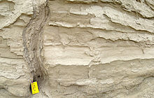
Sheeted clastic dike in the Touchet Beds.[59]
Tens of thousands of unusual clastic dikes (1 mm—350 cm wide) in Pleistocene sediments of southeastern Washington may be related to loading by outburst floods. Saturated material was injected along and enlarged preexisting weaknesses (shallow frost or desiccation cracks, joints in bedrock). Other lines of evidence suggest that these dikes may have formed when the flood-deposited Touchet Formation dried, leaving deep, open cracks which subsequently filled with debris. That would mean they are desiccation features — cracks formed as wet sediment dried and contracted. If desiccation features, the dikes would have formed by passive infilling of open fractures by windblown or washed in sediment over time. Some evidence suggests the dikes are fossil ice wedge casts or features related to the melting of buried ice. There is good proxy evidence for cold-climate conditions (periglacial or nearly so) at the time of their formation. The origin of the clastic dikes in the Columbia Basin is under debate.
Dikes sourced in Touchet Beds (or Touchet-like deposits of similar age and depositional history) are known to intrude downward into older geologic units including the Pleistocene Clearwater Gravels in the Lewiston Basin,[60] pre-late Wisconsin deposits in the Walla Walla Valley and Columbia Basin,[61] Miocene—Pliocene Snipes Mountain Conglomerate,[62][63][64] in the Yakima Valley, Miocene—Pliocene Ringold Formation,[65] Miocene Columbia River Basalt Group at Gable Mountain,[66] and the Walla Walla Valley,[67][68] and possibly the Alkali Canyon Fm (Dalles Group) in the Willow Creek Valley at Cecil, Oregon.
References
- ^ Richard J. Davies, R.J.; Huuse, M.; Hirst, P.; Cartwright, J.; Yang, Y., 2006, Giant clastic intrusions primed by silica diagenesis, Geology, 34, p. 917-920
- ^ Darwin, C., 1833-1834, Geological observations on the volcanic islands and parts of South America visited during the voyage of the H.M.S. “Beagle” (2nd Edition), p. 438
- ^ Hay, R., 1892, Sandstone dikes in northwestern Nebraska, GSA Bulletin, 3, p. 50-55
- ^ Case, E.C.; 1895, On the mud and sand dikes of the White River Miocene, Ithaca, N.Y., American Geologist, 24, p. 248-254
- ^ Cross, W., 1894, Intrusive sandstone dikes in granite, GSA Bulletin, 5, p. 225-230
- ^ Crosby, W.O., 1897, Sandstone dikes accompanying the great fault of Ute Pass, Colorado, Essex Institute Bulletin, 27, p. 113-147
- ^ Diller, J.S., 1890, Sandstone dikes, GSA Bulletin, 1, p. 411-442
- ^ G. Neef, A clastic dike-sill assemblage in late Miocene (c. 6 Ma) strata, Annedale, Northern Wairarapa, New Zealand, New Zealand Journal of Geology & Geophysics, 1991, Vol. 34: 87—91 http://www.rsnz.org/publish/nzjgg/1991/11.php
- ^ Peterson, C.D., 1997, Coseismic paleoliquefaction evidence in the central Cascadia margin, USA, Oregon Geology, 59, p. 51-74
- ^ Audemard, F.A.; de Santis, F., 1991, Survey of liquefaction structures induced by recent moderate earthquakes, Bulletin of the International Association of Engineering Geology, 44, p. 5-16
- ^ Ettensohn, F.R.; Rast, N.; Brett, C.E. (editors), Ancient Seismites, GSA Special Paper, 359
- ^ Kevin G. Stewart, 2003, Paleoseismology http://www.unc.edu/~kgstewar/web_pages/paleoseismology.html
- ^ Seilacher, A., 1969, Fault-graded beds interpreted as seismites, Sedimentology, 13, p. 15-159
- ^ Mills, P.C., 1983, Genesis and diagnostic value of soft-sediment deformation structures – a review, Sedimentary Geology, 35, p. 83-104
- ^ Groshong, R.H., 1988, Low-temperature deformation mechanism and their interpretation, GSA Bulletin, 100, p. 1329-1360
- ^ Allen, C.R., 1975, Geological criteria for evaluating seismicity, GSA Bulletin, 86, p. 1041-1057
- ^ Guiraud and Plaziet, 1993
- ^ Obermeier, S.F., 1996b, Use of liquefaction-induced features for paleoseismic analysis - an overview of how seismic liquefaction features can be distinguished from other features and how their regional distribution and properties of source sediment can be used to infer the location and strength of Holocene paleo-earthquakes, Engineering Geology, 44, p. 1-46
- ^ Greb, S.F.; Ettensohn, F.R.; Obermeier, S.F., 2002, Developing a classification scheme for seismites, GSA North-central & Southeastern Section Annual Meeting Abstracts with Programs
- ^ Wheeler, R.L., 2002, Distinguishing seismic from nonseismic soft-sediment structures: Criteria from seismic-hazard analysis, in Ettensohn, F.R.; Rast, N.; Brett, C.E. (editors), Ancient Seismites, GSA Special Paper, 359, p. 1-11
- ^ Obermeier, S.F.; Olson, S.M.; Green, R.A., 2005, Field occurrences of liquefaction-induced features: a primer for engineering geologic analysis of paleoseismic shaking, Engineering Geology, 76, p. 209-234
- ^ Montenat, C.; Barrier, P.; d'Estevou, P.O.; Hibsch, C., 2007, Seismites: An attempt at critical analysis and classification, Sedimentary Geology, 196, p. 5-30
- ^ Levi, T.; Weinberger, R.; Eyal, Y., in press 2010, A coupled fluid-fracture approach to propagation of clastic dikes during earthquakes, Tectonophysics
- ^ Mashchak, M.S.; Ezersky, V.A., 1980, Clastic dikes of the Kara Crater Pai Khoi, Lunar and Planetary Sciences, 11, p. 680-682
- ^ Mashchak, M.S.; Ezersky, V.A., 1982, Clastic dikes in the impactites and allogenic breccias of the Kara astrobleme (northeast slope of the Pai-Khoi Range) (article in Russian), Lithology and Economic Minerals, 1, p. 130-136
- ^ Sturkell, E.F.F.; Ormo, J., 1997, Impact-related clastic injections in the marine Ordovician Lockne impact structure, central Sweden, Sedimentology, 44, p. 793-804
- ^ Huntoon, P.W., 2000, Upheaval Dome, Canyonlands, Utah: Strain indicators that reveal an impact origin, in Sprinkel, D.A.; Chidsey, T.C.; Anderson, P.B. (editors), Geology of Utah's Parks and Monuments, Utah Geological Association Publication, 28, p. 1-10, revised 2002: http://www.utahgeology.org/Topical_papers_2003_UGA28.htm
- ^ Kenkmann, T., 2003, Dike formation, cataclastic flow, and rock fluidization during impact cratering: an example from the Upheaval Dome structure, Earth and Planetary Science Letters, 214, p. 43-58
- ^ Huntoon, P.W.; Shoemaker, E.M., 1995, Roberts Rift, Canyonlands, Utah, A natural hydraulic fracture caused by comet or asteroid, Ground Water, 33, p. 561-569
- ^ Wittmann, A.; Kenkamnn, T.; Schmitt, R.T.; Hecht, L.; Stöffler, D., 2004, Impact-related dike breccia lithologies in the ICDP drill core Yaxcopoil-1, Chicxulub impact structure, Mexico, Meteorics & Planetary Science, 39, p. 931-954
- ^ Hudgins, J.A.; Spray, J.G., 2006, Lunar impact-fluidized dikes: Evidence from Apollo 17 Station 7, Taurus-Littrow Valley, Lunar and Planetary Science, 37, p. 1176
- ^ Marco, S.; Weinberger, R.; Agnon, A., 2002, Radial clastic dykes formed by a salt diapir in the Dead Sea Rift, Israel, Terra Nova, 14, p. 288-294
- ^ Levi et al., 2006, Earthquake-induced clastic dikes detected by anisotropy of magnetic susceptibility, Geology, 34, p. 69–72
- ^ Kruger, F.C., 1938, A clastic dike of glacial origin, American Journal of Science, 5, p. 305-307
- ^ Goldthwait, J.W.; Goldthwait, L.; Goldthwait, R.P., 1951, Geology of New Hampshire, Part 1: Surficial Geology, New Hampshire State Planning and Development Commission, 44 pgs.
- ^ Amark, M., 1986, Clastic dikes formed beneath an active glacier, Geologiska Föreningens i Stockholm Förhandlingar, 108, p. 13–20
- ^ Dreimanis, A., 1992, Downward injected till wedges and upward injected till dikes, Sveriges Geologiska Undersökning, 4, p. 91-96
- ^ Larsen, E.; Mangerud, J., 1992, Subglacially formed clastic dikes, Sveriges Geologisha Undersdhning, 81, p. 163-170
- ^ Boulton, G.S.; Caban, P., 1995, Groundwater flow beneath ice sheets: Part II — Its impact on glacier tectonic structures and moraine formation, Quaternary Science Reviews, 14, p. 563-587
- ^ Dreimanis, A,; Rappol, M., 1997, Late Wisconsinan sub-glacial clastic intrusive sheets along the Lake Erie bluffs, at Bradtville, Ontario, Canada, Sedimentary Geology, 111, p. 225-248
- ^ Wicander, R.; Wood, G.D.; Dreimanis, A.; Rappol, M., 1997, Late Wisconsin sub-glacial intrusive sheets along Lake Eerie bluffs, at Bradtville, Ontario, Canada, Sedimentary Geology, 111, p. 225-248
- ^ Van Der Meer, J.J.M.; Kjaer, K.H.; Kruger, J., 1999, Subglacial water-escape structures and till structures, Slettjokull, Iceland, Journal of Quaternary Research, 14, p. 191-205
- ^ Rijsdijk, K.F.; Owen, G.; Warren, W.P.; McCarroll, D.; van der Meer, J.J.M., 1999, Clastic dykes in over-consolidated tills: Evidence for subglacial hydrofracturing at Killiney Bay, eastern Ireland, Sedimentary Geology, 129, p. 111-126
- ^ Le Heron, D.P.; Etienne, J.L., 2005, A complex subglacial clastic dyke swarm, Solheimajokull, southern Iceland, Sedimentary Geology, 181, p. 25-37
- ^ Gozdzik, J.; Van Loon, A.J., 2007, The origin of a giant downward directed clastic dyke in a kame (Belchatow mine, central Poland), Sedimentary Geology, 193, p. 71-79
- ^ Crossen, K., 2009, Is till the only evidence of ice advance? What 15 year of post-surge retreat have revealed beneath Bering Glacier, Alaska, GSA Abstracts with Programs, Abstract #247-8
- ^ Van Der Meer, J.J.M.; Kruger, J.; Rabassa, J.; Kilfeather, A.A., 2009, Under pressure: Clastic dykes in glacial settings, Quaternary Science Reviews, 28, p. 708-720
- ^ Cross, W., 1894, Intrusive sandstone dikes in granite, GSA Bulletin, 5, p. 225-230
- ^ Birman, J.H., 1952, Pleistocene clastic dikes in weathered granite-gneiss, Rhode Island, American Journal of Science, 250, p. 721-734
- ^ Vitanage, P.W., 1954, Sandstone dikes in the South Platte Area, Colorado, Journal of Geology, 62, p. 493-500
- ^ Harms, J.C., 1965, Sandstone dikes in relation to Laramide faults and stress distribution in the southern Front Range, Colorado, GSA Bulletin, 76
- ^ Niell, A.W.; Leckey, E.H.; Pogue, K.R., 1997, Pleistocene dikes in Tertiary rocks - downward emplacement of Touchet Bed clastic dikes into co-seismic features, south-central Washington, GSA Abstracts with Programs, 29, p. 55
- ^ Beacom, L.E.; Anderson, T.B.; Holdsworth, R.E., 1999, Using basement-hosted clastic dykes as syn-rift palaeostress indicators; an example from the basal Stoer Group, northwest Scotland, Geological Magazine, 136, p. 301-310
- ^ Haluszczak, A., 2007, Dike-filled extensional structures in Cenozoic deposits of the Kleszczow Graben (Central Poland), Sedimentary Geology, 193, p. 81-92
- ^ Dalrymple, R.W., 1979, Wave-induced liquefaction: A modern example from the Bay of Fundy, Sedimentology, 26, p. 835-844
- ^ Alfaro, P.; Soria, M., 1998, Soft-sediment deformation structures induced by cyclic stress of storm waves in tempestites (Miocene, Guadalquivir Basin, Spain), Terra Nova, 10, p. 145-150
- ^ Martel, A.T.; Gibling, M.R., 1993, Clastic dykes of the Devono-Carboniferous Horton Bluff Fm, Nova Scotia: Storm-related structures in shallow lakes, Sedimentary Geology, 87, p. 103-119
- ^ Olson, S.M., 2007, Downward penetrating clastic dikes as indicators of tsunamis? GSA Southeastern Section Abstracts with Programs, 39, p. 25 (#14-5)
- ^ Carson, R.J.; Pogue, K.R., 1996, Flood Basalts and Glacier Floods: Roadside geology of parts of Walla Walla, Franklin, and Columbia Counties, WA, Washington State Division of Geology and Earth Resources Information Circular 90
- ^ Othberg et al., 2003
- ^ Spencer, P.K.; Jaffee, M.A., 2002, Pre-late Wisconsinan glacial outburst floods in southeastern Washington: The indirect record, Washington Geology, 30, p. 9-16
- ^ Campbell, N.P., 1977, Geology of the Snipes Mountain area, Yakima County, Washington, Washington State Division of Geology & Earth Resources Open File Report, 77-8, 3 maps, 1:24,000 scale
- ^ Smith, G.A.; Bjornstad, B.N.; Fecht, K.R., 1989, Neogene terrestrial sedimentation on and adjacent to the Columbia Plateau; Washington, Oregon, and Idaho, in Reidel, S.P.; Hooper, P.R. (editors), GSA Special Paper, 239, p. 187-198
- ^ Reidel et al., 1994
- ^ Brown, D.J.; Brown, R.E., 1962, Touchet clastic dikes in the Ringold Fm, Hanford Operations Report, HW-SA-2851, p. 1-11
- ^ Fecht, K.R.; Bjornstad, B.N.; Horton, D.G.; Last, G.V.; Reidel, S.P. Lindsey, K.A., 1998, Clastic injection dikes of the Pasco Basin and vicinity, Bechtel Hanford Inc Report, BHI-01-01103
- ^ Cooley, S.W.; Pidduck, B.K.; Pogue, K.R., 1995, Mechanism and timing of emplacement of clastic dikes in the Touchet Beds of the Walla Walla Valley, Geological Society of America Cordilleran Section Abstracts with Programs, 28, p. 57
- ^ Pogue, K.R., 1998, Earthquake-generated(?) structures in Missoula flood slackwater sediments (Touchet Beds) of southeastern Washington, Geological Society of America Abstracts with Programs, 30, p. A398
Categories:- Sedimentary rocks
Wikimedia Foundation. 2010.

