- Virginia State Route 37
Infobox road
state=VA
type=
route=37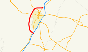
maint=Virginia DOT
length_mi=9.104
length_ref=Virginia Department of Transportation , [http://gis.virginiadot.org/data_download/data_download_draft_roadway_network.asp DRAFT Roadway Network] (GIS data ), October 2006]
length_round=3
established=early 1960s
direction_a=South
direction_b=North
starting_terminus=jct|state=VA|I|81 south of Winchester
junction=jct|state=VA|US|50 west of Winchester
jct|state=VA|US|522 northwest of Winchester
ending_terminus=jct|state=VA|US|11|to2=to|I|81 north of Winchester
previous_type=SR
previous_route=36
next_type=SR
next_route=38State Route 37 (SR 37) is a primary
state highway in theU.S. state ofVirginia . It forms a western bypass of Winchester, connecting to Interstate 81 at both ends. Although the road is afreeway , neither I-81 connection is freeway standard; the south end (exit 310) is adiamond interchange with twotraffic signal s, while, at the north end, drivers must use a short piece of U.S. Route 11 to connect with I-81 at exit 317. In addition to local access, the highway connects to U.S. Route 50 and U.S. Route 522, two major highways that lead west and northwest intoWest Virginia and north to Interstate 70 atHancock, Maryland . An eastern bypass, known locally as "Route 37 East", has been proposed in statewide and local plans to complete the loop. [Frederick County, Virginia Board of Supervisors, [http://www.co.frederick.va.us/boardofsup/Minutes/032702.htm Board Meeting Minutes] ofMarch 27 ,2002 ] [Stephanie K. Moran,Winchester Star , VDOT to Cut Road Budget by a Third,May 16 ,2002 ] [Winchester Star , Supervisors to Wait for Word on Va. 37 East,January 16 ,2004 ] [Virginia Department of Transportation , [http://www.virginiadot.org/projects/resources/staunton.pdf 2025 State Highway Plan: Primary System, Staunton District] ] [Win-Fred Metropolitan Planning Organization , [http://www.winfredmpo.org/pdf/winfredmpo_2030transplan_mapside.pdf 2030 Transportation Plan] ]Route description
Route 37 begins at an intersection with Hillandale Road (SR 847), a local
frontage road along the east side of I-81, and Tasker Road (SR 642), which leads southeast to US 522 near Armel. It immediately crosses I-81 at exit 310, adiamond interchange with twotraffic signal s on SR 37, and then becomes afreeway , soon junctioning US 11 (Valley Pike ) with apartial cloverleaf . The next interchange is a diamond atCedar Creek Grade (SR 622), and SR 37 reaches its approximate midpoint at US 50 (Northwestern Pike ), another diamond. Atrumpet interchange completed in 2001 connects to theWinchester Medical Center , and the final diamond is with US 522 (Frederick Pike) at the northwestern corner. SR 37 ends at a partial Y interchange with US 11 (Martinsburg Pike ), at which SR 37 traffic can only access US 11 north and only traffic from US 11 south can access SR 37, although a northbound exit to Cives Lane was added in about 2000 to allow SR 37 traffic to access US 11 south. About 1/2 mile (1 km) of US 11 is adivided highway , connecting SR 37 with I-81 at exit 317.Google Maps street maps andUSGS topographic map s, accessed via [http://mapper.acme.com/ ACME Mapper] ]History
Route 37 was defined as the proposed Winchester By-Pass by 1963, [CTB minutes|03-1963-01, p. 55] and was included in the statewide Arterial Network when it was created in 1964. [CTB minutes|03-1964-01, p. 27] When I-81 opened past Winchester in November 1965, [
Virginia Department of Transportation , [http://www.virginiadot.org/projects/constSTAN-I81-history.asp I-81 History] ,October 29 ,2006 ] it included an interchange south of Winchester, taking traffic between I-81 and US 11 along a short connecting road.United States Geological Survey , [http://www.lib.utexas.edu/maps/topo/250k/txu-pclmaps-topo-us-cumberland-1969.jpgCumberland, MD.; W. VA.; PA.; VA.] (scale 1:250,000), 1956, revised 1969] The north half of the bypass, from US 50 west of Winchester north and east to US 11 north of the city, opened in the late 1960s, and the semicircle was completed in the late 1970s, with the linking of Route 37 to the existing I-81/US 11 connection. A new bridge carrying southbound SR 37 over I-81 was built, but otherwise thediamond interchange was not modified.Federal Highway Administration ,National Bridge Inventory database, 2006] The only change to the major bypass since it was constructed has been a newtrumpet interchange serving theWinchester Medical Center ; construction began in September 2000 [Winchester Star , Long-Awaited Interchange on Way,September 22 ,2000 ] and was completed in November 2001. [Winchester Star , Halseth Enumerates VHS 2001 Growth,May 15 ,2002 ] A single ramp from SR 37 north to Cives Lane, allowing traffic at the north end of the bypass to access US 11 south, was built in about 2000. [Frederick County, Virginia Board of Supervisors, [http://www.co.frederick.va.us/boardofsup/Minutes/061202.htm Meeting Minutes of 06/12/2002] : "Resolution Re: Changes in the Primary and secondary System Due to relocation, Construction and Right-of-Way Abandonment on Entrance and Exit Ramps on Route 37 at its Intersection with Route 11 North"]Exit list
The entire route is in unincorporated Frederick County.
References

Wikimedia Foundation. 2010.