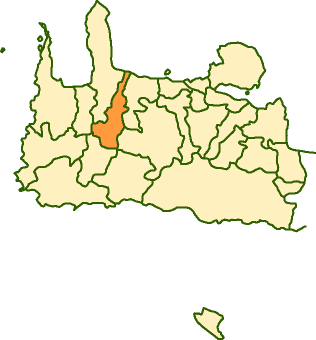
- Voukolies
Infobox Greek Dimos
name = Voukolies
name_local = Βουκολιές
periph =Crete
prefec = Chania
population = 3296
population_as_of = 2001
area =
elevation =
lat_deg = 35
lat_min = 29
lon_deg = 23
lon_min = 49
postal_code = 730 02
area_code = 28240
licence = ΧΝ, XB
mayor = Nikolaos Bompolakis
website = [http://www.chania.gr/dimoishow.jsp?lang=en&id=6 Voukolies Website]
caption_skyline =
city_
city_
districts =
party =
since =
elevation_min =
elevation_max =Voukolies ( _el. Βουκολιές, Δήμος Βουκολιών) is a town and municipality in the west of the island of
Crete ,Greece . It is part of the Kissamos province which covers the northwestern part ofChania Prefecture . Voukoulies is a large village with an important Saturday morning market. The municipality of Voukoulies extends fromTavronitis on the north coast to the foothills of the White Mountains ("Lefka Ori "). The head town of the municipality isVoukoulies itself. The municipality also includes Tavronitis,Neriana ,Kakopetros ,Polemarchi , Neo Chorio,Anoskeli andPalea Roumata .ee also
*
List of communities of Chania External links
* [http://www.chania.gr/dimoishow.jsp?lang=en&id=6 Municipality Description]
* [http://www.gtp.gr/LocPage.asp?id=593 GTP Description]
Wikimedia Foundation. 2010.
