- Donegal School District
-
Donegal School District 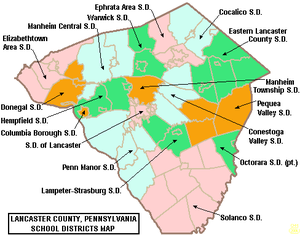
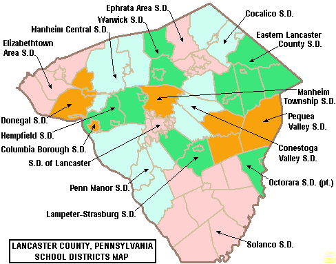
Map of Lancaster County, Pennsylvania Public School Districts. Donegal School District is the large orange area to the left (west) side of the map. Address 1051 Koser Road
Mount Joy, Pennsylvania, Lancaster, 17552
United StatesInformation Superintendent Dr. Shelly M. Riedel, Ed.D. Faculty 162 Grades K-12 Enrolment 2538 Campus type Rural Mascot Tribe Website http://www.donegal.k12.pa.us/ The Donegal School District is a school district covering the Boroughs of Marietta and Mount Joy and East Donegal Township and the southern portion of Mount Joy Township in Lancaster County, Pennsylvania. It is a member of Lancaster-Lebanon Intermediate Unit (IU) 13. The district operates one High School, one Middle School, three Elementary Schools and one Kindergarten facility.
Contents
Comparison to other Lancaster County school districts
2006 SAT: average scores
Lancaster County schoolsSchool District Reading Math Writing Total Cocalico 473 489 467 1429 Columbia Borough 445 435 419 1299 Conestoga Valley 505 513 501 1519 Donegal 511 531 490 1532 Eastern Lancaster County 506 521 494 1521 Elizabethtown Area 501 520 490 1511 Ephrata Area 488 498 472 1458 Hempfield 522 565 505 1592 Lampeter-Strasburg 522 527 501 1550 Lancaster 449 448 448 1316 Manheim Central 503 520 491 1517 Manheim Township 547 565 535 1647 Penn Manor 492 513 474 1479 Pequea Valley 505 508 481 1494 Solanco 506 516 482 1504 Warwick 527 527 509 1563 County average 500 512 484 1496 Pennsylvania average 493 500 483 1476 U.S. average 503 518 497 1518 Possible on each test: 800 points
Source: "Blame it on fried brains",
September 21, 2006 Lancaster New EraPennsylvania System of School Assessment
2005-2006 PSSA proficiency levels for Lancaster County schoolsSchool District 3-5 Reading 3-5 Math 6-8 Reading 6-8 Math 9-12 Reading 9-12 Math Cocalico[1] 67.7% 83.3% 82.7% 79.7% 63.4% 51.7% Columbia Borough[2] 64.0% 71.1% 66.1% 56.9% 47.7% 25.2% Conestoga Valley[3] 71.3% 82.1% 76.9% 75.5% 75.7% 68.0% Donegal[4] 63.0% 69.2% 70.0% 62.1% 70.7% 57.2% Eastern Lancaster County[5] 69.6% 84.0% 84.2% 78.8% 73.6% 58.4% Elizabethtown Area[6] 70.6% 81.4% 80.9% 76.9% 72.1% 64.4% Ephrata Area[7] 67.7% 82.8% 81.1% 71.0% 61.4% 65.0% Hempfield[8] 80.3% 80.0% 81.3% 79.7% 75.7% 73.4% Lampeter-Strasburg[9] 83.6% 83.0% 90.0% 84.2% 78.6% 70.1% Lancaster[10] 45.6% 59.8% 46.5% 42.4% 41.5% 31.2% Manheim Central[11] 72.1% 79.1% 77.9% 66.8% 74.2% 62.3% Manheim Township[12] 80.1% 86.9% 90.4% 82.6% 82.7% 76.1% Penn Manor[13] 70.8% 82.0% 78.3% 73.5% 78.1% 71.0% Pequea Valley[14] 73.8% 83.9% 68.0% 70.1% 72.8% 56.5% Solanco[15] 77.7% 83.9% 80.5% 75.1% 73.1% 54.6% Warwick[16] 71.4% 83.0% 77.5% 75.1% 76.1% 62.5% In some cases, 2 (or even 3) years were aggregated by Pennsylvania Department of Education Statistical snapshot
Donegal School District Schools 6 Students 2538 Full Time Teachers 162 Student/Teacher Ratio 17:1 Male students 759 Female students 2000 Native American students 6 Asian students 29 Hispanic students 92 Black students 43 White (non-Hispanic) students 2368 Pre-Kindergarten 0 Kindergarten 160 1st Grade 164 2nd Grade 197 3rd Grade 193 4th Grade 206 5th Grade 190 6th Grade 213 7th Grade 239 8th Grade 207 9th Grade 239 10th Grade 193 11th Grade 164 12th Grade 173 Source: Local School Directory[1]
Schools
- Donegal Kindergarten Center Marietta, Pennsylvania
- Donegal Springs Elementary School Mount Joy, Pennsylvania
- Maytown Elementary School Maytown, Pennsylvania
- Riverview Elementary School Marietta, Pennsylvania
- Donegal Middle School Marietta, Pennsylvania
- Donegal Senior High School Mount Joy, Pennsylvania
See also
Categories:- School districts in Lancaster County, Pennsylvania
Wikimedia Foundation. 2010.