- Binnein an Fhidhleir
-
Binnein an Fhidhleir (Stob Coire Creagach) 
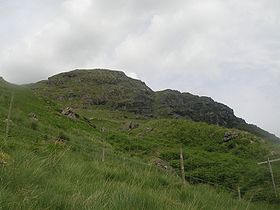
Binnein an Fhidhleir (Stob Coire Creagach top) seen from ButterbridgeElevation 817 m (2,680 ft) Prominence 504 m (1,654 ft) Parent peak Beinn Ime Listing Corbett, Marilyn Translation The fiddler's peak (Peak of the rocky corrie [1]) (Scottish Gaelic) Pronunciation Scottish Gaelic: [ˈpiɲɛɲ ən̪ˠ ˈiʝlɛrˠ] Location Location Argyll and Bute,  Scotland
Range Arrochar Alps, Grampian Mountains OS grid NN230109 Binnein an Fhidhleir, one of the Arrochar Alps, is a mountain in southern Scotland. It is located above Butterbridge on the north side the A83 road facing Beinn an Lochain to the south. The mountain has several tops, including Creag Bhrosgan (711 m); Stob Coire Creagach, which replaced Binnein an Fhidhleir as the Marilyn in April 2006 [2] at 817 m; one without any name at all at 748 metre; and Binnein an Fhidhleir itself, further to the west[3], at 811 m. Although Stob Coire Creagach is the highest summit, the name Binnein an Fhidhleir is generally used for the whole mountain.
The shortest route of ascent is directly up the hillside above Butterbridge, where there is a carpark. A number of small crags must be avoided, and the route is steep and unrelenting. Alternatively, the hill may be ascended from further up Glen Kinglas by way of Binnein an Fhidhleir's northern ridge: although longer this route is considerably less steep.
References
- ^ "Stob Coire Creagach". MunroMagic. http://www.munromagic.com/MountainInfo.cfm?Mountain=417. Retrieved September 23, 2006.
- ^ Alan Dawson (2006). "Update to The Relative Hills of Britain". http://www.rhb.org.uk/updates/up200604.htm.
- ^ Multimap.com. "A circle around the highest top, Binnein an Fhidhleir is located more to the west". http://uk.multimap.com/map/browse.cgi?client=public&X=223000.00004174&Y=711000.072780575&width=700&height=400&gride=223000.00004174&gridn=710900.072780575&srec=0&coordsys=gb&db=grid&addr1=&addr2=&addr3=&pc=&advanced=&local=&localinfosel=&kw=&inmap=&table=&ovtype=&keepicon=true&zm=1&scale=100000.
Arrochar Alps Munros Corbetts Beinn an Lochain 901 m · Beinn Chorranach 888 m · The Cobbler (Ben Arthur) 884 m · Beinn Luibhean 857 m · A' Chrois 848 m · Ben Donich 847 m · Binnein an Fhidhleir 817 m · The Brack 787 m · Beinn Bheula 779 mOther Marilyns Cnoc Coinnich 761 m · Stob an Eas 732 m · Beinn Lochain 703 m · Cruach nam Mult 611 m · Cruach nam Miseag 607 mCoordinates: 56°15′27″N 4°51′32″W / 56.25752°N 4.85899°W
Categories:- Marilyns of Scotland
- Corbetts
- Mountains and hills of the Southern Highlands
- Mountains and hills of Argyll and Bute
- Argyll and Bute geography stubs
Wikimedia Foundation. 2010.
