- Colintraive
-
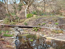 Colintraive community garden is built on the site of a smiddy and meal mill, this is the former mill pond
Colintraive (Scottish Gaelic: Caol an t-Snàimh) is a village in Argyll and Bute, Scotland. Ferries sail between Colintraive and Rhubodach on the Isle of Bute. It is located on the Kyles of Bute or Loch Riddon on the west coast of the Cowal peninsula. The nearest town of notable size is Dunoon which is a twenty minute drive away on the east coast of the peninsula facing Gourock and the River Clyde, heading to Port Glasgow and Greenock.
The village faces the Isle of Bute where a ferry journeys the 100 yard gap between Colintraive and the isle. On the island there is one fairly modest tourist town called Rothesay. Also there is the famous Scalpsie Bay often regarded as one of the best seal viewing points in the world.
The name Colintraive derives from Gaelic and means "swimming strait" or "swimming narrows". In the past, cattle were swum over from the Isle of Bute to Colintraive on their way to the cattle markets of lowland Scotland.
Colintraive is known, along with its neighbouring village of Glendaruel as Col-Glen, which is also the name of the local shinty team.
Though the village is quite small there is now an hotel and pub-restaurant, along with one small adjoining post office.
On 25 March 2011, a decomposed body of a woman was found on the shore of Loch Striven at Troustan, near Colintraive. It was later revealed to be the body of 63-year-old Jennifer Thomson,[1] a hillwalker from Methven, Perthshire, who went missing in March 2007.[2]
References
- ^ "Methven teacher Jennifer Thomson’s body found" - Perthshire Advertiser, 8 April 2011
- ^ "HORROR FIND" - Dunoon Observer and Argyllshire Standard, 27 March 2011
Coordinates: 55°55′25″N 5°8′43″W / 55.92361°N 5.14528°W
Categories:- Ports and harbours of Scotland
- Villages in Argyll and Bute
- Cowal
- Argyll and Bute geography stubs

Wikimedia Foundation. 2010.