- Tambora, Jakarta
-
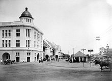
 An early 20th century picture showing the area of Jakarta Old Town that is located in Tambora Subdistrict, west of Kali Besar canal. Most of these buildings, including the former Chartered Bank on the left, still exist today.
Tambora is a subdistrict of West Jakarta, Jakarta, Indonesia. Tambora Subdistrict is bounded by a railway to the west and to the north, Kali Krukut - Kali Besar canal to the east, and Duri Selatan Road to the south.
The Roa Malaka Administrative Village of the Tambora Subdistrict contains the southwestern area of Jakarta Old Town, the area on the west side of Kali Besar Canal. The area of Jakarta Old Town that was located within Tambora are generally residential areas. Notable colonial buildings are located along the Kali Besar Canal, most of them are former palaces or houses dating from the 18th century. These buildings are now mostly used as offices.[1]
Contents
Kelurahan (Administrative Villages)
The subdistrict of Tambora is divided into eleven kelurahan or administrative villages:
- Tanah Sareal - area code 11210
- Tambora - area code 11220
- Roa Malaka - area code 11230
- Pekojan - area code 11240
- Jembatan Lima - area code 11250
- Krendang - area code 11260
- Duri Utara - area code 11270
- Duri Selatan - area code 11270
- Kali Anyar - area code 11310
- Jembatan Besi - area code 11320
- Angke - area code 11330
List of important places
- Angke (Al Anwar) Mosque, located in Angke Administrative Village, is the only mosque in Jakarta that has remained unaltered since it was built. Its roof is on two levels, the typical Javanese style for roofs of places of worship. In 1856 Prince Syarif Hamid, a Sultan from Pontianak was captured by the Dutch and held at Manggadua. When he died he was buried in front of the mosque on July 17, 1858. People from Pontianak often visit his grave and many of them have decided to stay at Angke. Many Chinese in this area are devout Moslems. Many tombstones near the mosque bear Chinese as well as Arabic inscriptions. The oldest tombstones show Islamic Banten and Aceh origins.[2]
- Former Chartered Bank
- Omni Batavia Hotel
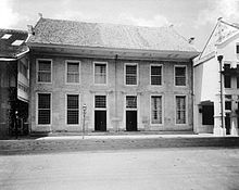
- Toko Merah (Indonesian "Red Shop") was built in 1730 as the residence of the Governor-General of the Dutch East Indies Gustaaf Willem baron van Imhoff. In 1743-1755 this building served as Navy Academy. Afterwards, this building changed its ownership for several times.[3]
References
- ^ Adolf Heuken SJ (2007). Historical Sites of Jakarta. Cipta Loka Caraka Foundation, Jakarta.
- ^ "Angke Mosque". Enjoy Jakarta. Jakarta Tourism Board. 2008. http://jakarta-tourism.go.id/wisatadkiapp/content/en/130/angke-mosque. Retrieved March 24, 2010.
- ^ "Red Shop". Enjoy Jakarta. Jakarta Tourism Board. 2008. http://jakarta-tourism.go.id/wisatadkiapp/content/en/145/red-shop. Retrieved March 24, 2010.
External links
- (Indonesian) Official site
Administrative areas of the Special Capital Territory of Jakarta Cities and Regency of JakartaCentral Jakarta Cempaka Putih • Gambir • Johar Baru • Kemayoran • Menteng • Sawah Besar • Senen • Tanah Abang
West Jakarta Cengkareng • Grogol • Kalideres • Kebon Jeruk • Kembangan • Palmerah • Taman Sari • Tambora
South Jakarta Cilandak • Jagakarsa • Kebayoran Baru • Kebayoran Lama • Mampang Prapatan • Pancoran • Pasar Minggu • Pesanggrahan • Setiabudi • Tebet
East Jakarta Cakung • Cipayung • Ciracas • Duren Sawit • Jatinegara • Kramat Jati • Makasar • Matraman • Pasar Rebo • Pulo Gadung
North Jakarta Cilincing • Kelapa Gading • Koja • Pademangan • Penjaringan • Tanjung Priok
Thousand Islands Categories:- Areas of Jakarta
- Jakarta geography stubs
Wikimedia Foundation. 2010.


