- Sankt Anton am Arlberg
Infobox Town AT
name=St. Anton am Arlberg
name_local=
image_coa = Wappen at st anton am arlberg.png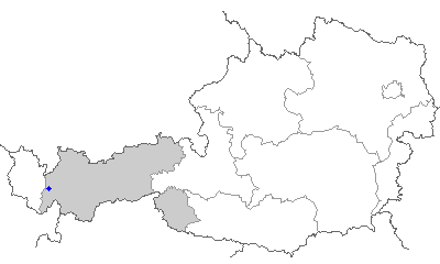
state =Tyrol
regbzk =
district = Landeck
population =2848
population_as_of = 01.01.2006
population_ref =
pop_dens =
area = 165.81
elevation = 1304
lat_deg=47
lat_min=07
lat_hem=N
lon_deg=10
lon_min=16
lon_hem=E
postal_code = 6580
area_code =05446
licence = LA
mayor = Rudolf Tschol (ÖVP)
website = [http://www.st-anton.at www.st-anton.at]Sankt Anton am
Arlberg is a village in Tyrol, westernAustria , with a population of c. 2,800. It is a prominentski resort situated at 1,304 m above sea level in theTyrolean Alps with dozens ofAerial tramway s,chair lift s and ski-lifts up to 2,811 m. It is well known around the world as the host of the Alpine World Skiing Championships in 2001 and as one of the world's most famous internationalwinter sport s and a summer resort. Skiing has a long history in this village: even before World War I, the first skiing teachers were employed at St. Anton. It is located in the Stanzertal and belongs to the district ofLandeck .The resort
A town of 2,500 permanent inhabitants, St. Anton offers the best expert
skiing in theArlberg region, and the most livelyapres-ski scene. St. Anton lies on the Rosanna River, and is on the main east-west rail line between Austria and Switzerland. It is part of the Arlberg alliance of ski resorts—a region that includes more 82 cable cars and ski lifts, 260 km (160 miles) of groomed pistes and 184 km (114 miles) of deep-snow runs.A pedestrian zone forms the center of the town. On the western edge of village is the "Galzigbahn" which has been replaced by a
Funitel gondola. The new gondola also includes the first ever Ferris wheel which enables passengers to board the gondolas on ground level. The Funitel accesses the Galzig slopes and connects to Schindler and Valluga peaks. On the eastern edge of town, the "Nassereinerbahn" rises to the Nasserien area with links to Kapall peak. Kapall, Valluga, and Schindler peaks provide skiers with close to 1,500 vertical metres skiing. Slope-side apres-ski bars, such as Krazy Kanguruh and Mooserwirt, can be found on the Steissbachtal trail just above St. Anton. A more subdued apres-ski scene exists in the numerous pubs and cafes in town.Expert terrain includes less frequently groomed ski routes such as Schindlerkar and Mattun, and the backside of
Valluga (2,811 m) down toZürs , which is for experts only if accompanied by a guide. There are also a large number of off-piste routes in the area that experts can explore with the help of a guide. Rendl, a separate area on the other side of town, is more suitable for intermediates. It also gets the late afternoon sun. Many people end the day at the Rendl Beach--a lively outside bar with a sun terrace and dailytea dance s.Other ski areas are Lech, Stuben and St. Christoph, a hamlet that became famous in the 14th century when the shepherd Heinrich Findelkind built a hospice as a shelter for traveler crossing the Arlberg pass to the Vorarlberg province. Alpe Rauz, near St. Christoph, has one of the finest cruising trails in the region, an 820 m vertical slope that takes one all the way from Ulmer Hutte to Stuben.
tats
* Elevation: Base/Village: 1,304 m (4,278 ft); Top: 2,811 m (9,222 ft). Stuben: Base: 1,407 m (4,616 ft); Top: 2,600 m (8,530 ft)
* Vertical: 1,507 m (4,944 ft). Stuben 1,207 m (3,960 ft)
* Longest Run: 10.2 km (6.3 mi); Valluga to St. Anton
* Terrain: 262 km (161 mi) of groomed slopes in region; 36% beginner (blue), 42% intermediate (red), 22% advanced and expert (black) Plus 184 km (114 mi) of deep snow runs
* Lifts: 82 (Arlberg Ski Area)
* Types: 10 Gondolas; 38Chairlifts (one 8 psngr, seven 6 psngr, 11 quads, 4 triples, 15 doubles); 34 T-bars
* Lift Capacity: 123,600 persons p/h [ [http://www.stantonamarlberg.com/winter/ViewPage.asp?Site=STANTON2-WINTER&PageID=206&lang=201] ]
* Ski Season: Late November-late April or beginning of May
* Cross country: 37.5 km (23 mi) total: Stanzertal 22 km, Ferwall 10 km, St. Christoph 2.5 km, Ganderau (3km); 65 km (40 mi) in the region.
* Mountain Restaurants: 18
* Après-Ski: Ski museum; 15 cafes, 8 ice bars, 3 discos, 8 bars
* Lodging: 8,900 beds; hotels, gasthof, apartments, private pensions in St. Anton, St. Jakob, & St. Christoph. Stuben has 300 hotel beds and 340 private beds
* Transportation: Gateway Airports:Munich /Zürich /Friedrichshafen. Closest Austrian Airport:Innsbruck 103 km (64 mi) 1.5 hrs by train
* By Auto from airport: Munich (3.5 hrs.) Zürich (2.5 hrs.) Friedrichshafen (1.5 hrs.)
* By Train: Munich to Innsbruck, transfer with Arlberg Express to center of St. Anton; Zürich to St. AntonReferences
* Chris Gill & Dave Watts, "Where to Ski and Snowboard 2007", ISBN 0-9536371-8-2.
* [http://www.dcski.com/articles/view_article.php?article_id=450&mode=search John Darrell Sherwood, "Going Further Afield: At. Anton Austria," 23 February 2003]
* [http://www.ski-europe.com/resorts/stanton.html Ski-Europe Article on St. Anton]* Jacqueline McGibbon, "The Business of Alpine Tourism in a Globalising World" - an anthropological study of international tourism in the village of St. Anton am Arlberg in the Tirolean Alps.
External links
* [http://www.stantonamarlberg.com/ St. Anton Tourist Office Website]
* [http://www.checkcams.com/austria/st_anton_am_arlberg Webcams in St. Anton am Arlberg]
* [http://www.stantonamarlberg.at Weather, Webcams, Videos, etc. from St. Anton am Arlberg]
* [http://www.supertravel.co.uk/StAnton.htm St Anton Chalets]
* [http://www.krazykanguruh.com Krazy Kanguruh apres ski bar]
Wikimedia Foundation. 2010.