- Tamale, Ghana
Infobox Settlement
official_name = Tamale
other_name =
native_name =
nickname =
settlement_type =
motto =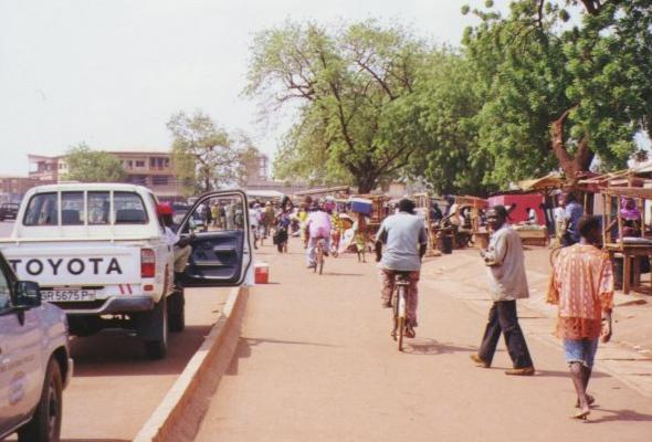
imagesize = 300px
image_caption = Bolga Road in downtown Tamale (November 1999)
flag_size =
image_
seal_size =
image_shield =
shield_size =
image_blank_emblem =
blank_emblem_type =
blank_emblem_size =
mapsize =
map_caption =
mapsize1 =
map_caption1 =
image_dot_
dot_mapsize =
dot_map_caption =
dot_x = |dot_y =
pushpin_
pushpin_label_position =bottom
pushpin_map_caption =Location in Ghana
subdivision_type = Country
subdivision_name =
subdivision_type1 = Admin. Region
subdivision_name1 = Northern Region
subdivision_type2 = District
subdivision_name2 =Metropolitan Area
subdivision_type3 =
subdivision_name3 =
subdivision_type4 =
subdivision_name4 =
government_footnotes =
government_type =
leader_title =Mayor
leader_name =Mohammed Amin Adam
leader_title1 =
leader_name1 =
leader_title2 =
leader_name2 =
leader_title3 =
leader_name3 =
leader_title4 =
leader_name4 =
established_title =
established_date =
established_title2 =
established_date2 =
established_title3 =
established_date3 =
area_magnitude =
unit_pref =Imperial
area_footnotes =
area_total_km2 =
area_land_km2 =
area_water_km2 =
area_total_sq_mi =
area_land_sq_mi =
area_water_sq_mi =
area_water_percent =
area_urban_km2 =
area_urban_sq_mi =
area_metro_km2 =
area_metro_sq_mi =
area_blank1_title =
area_blank1_km2 =
area_blank1_sq_mi =
population_as_of = 2007
population_footnotes =
population_note =
population_total = 550,000
population_density_km2 =
population_density_sq_mi =
population_metro =
population_density_metro_km2 =
population_density_metro_sq_mi =
population_urban =
population_density_urban_km2 =
population_density_urban_sq_mi =
population_blank1_title =Ethnicities
population_blank1 =
population_blank2_title =Religions
population_blank2 =
population_density_blank1_km2 =
population_density_blank1_sq_mi =
timezone =
utc_offset =
timezone_DST =
utc_offset_DST =
latd=9 |latm=24 |lats=27 |latNS=N
longd=0 |longm=51 |longs=12 |longEW=W
elevation_footnotes =
elevation_m =
elevation_ft =
postal_code_type =
postal_code =
area_code =
blank_name =
blank_info =
blank1_name =
blank1_info =
website = www.tamalemetropolis.org
footnotes = Tamale (pronounced [IPA|'ta ma lɛ] ) is the capital of the Northern Region ofGhana , with a population of 305,000 (2005). It is mostly populated byDagomba people who speak Dagbani and are followers ofIslam . It is located in the northern part of the country, where the land issavanna , consisting of grasslands with drought-resistant trees. The city is like a conglomeration of villages, with many people living in traditionalmud brick houses. While majority of the houses are roofed with corrugated iron sheets, a good number of them are roofed with grass. Many of these mud block compounds have TV antennae and electricity wires.The [http://www.ghanauniversities.com/university_detail.php?id=4 University for Development Studies] has a campus located in Tamale.Tamale has electricity which is transported from theAkosombo Dam in the central part of Ghana. The electricity service has been relatively reliable. During periods of drought, Tamale experiences rolling blackouts because of the rationing of electricity (and water through the dam).Telephone service is available. Cell phones are also available.
There are several
Internet cafe s located on the major roads in Tamale. The Internet cafes are connected throughAfrica Online , which also offers dialup service to home users. Africa Online's Tamale office has a 256 kbit/s satellite link which is connected to a proxy server for web surfing. All direct TCP/IP traffic is channeled through a 64 kbit/s line to Accra, the capital city. Thus, theworld wide web is perfectly usable in Tamale, but all other Internet applications experiencepacket loss and intermittent problems. Tamale boasts of the best road network in Ghana. It has been voted three consecutive times as the cleanest city in Ghana.Tamale has developed and transformed very fast within the last few years and often referred to the as the fastest growing city in West Africa. It now serves as a gateway to the Sahel considering its strategic positions as the centre between Ghana and her neighbours such as Burkina Faso, Niger, Mali, Benin, Cote D'voire and Togo. It has an International Airport which could make Tamale the aviation hub of the sub-region. The city authorities are also developing an Inland Transit Port to promote sub-regional trade. It is also the gateway to all the important tourism sites in Northern Ghana.
The new dimension of Tamale's development is the rush by various companies to open branches in the city. In two years, about six Financial Institutions (Banks) have opened branches in the city. The hospitality industry has also grown significantly with new hotels and guest houses built around the city especially during the count down to the African Cup of Nations Soccer Tournament of 2008.
There are numerous NGOs with offices in Tamale:
*USAID
* Catholic Relief Services (CRS)
* Ghana Institute of Linguistics, Literacy, and Bible Translation ( [http://www.gillbt.org GILLBT] )
* Northern Empowerment Association ( [http://www.grid-nea.com/ NEA] )
* Tamale Institute of Cross-Cultural Studies ( [http://www.ticcs.com/ TICCS] )
* [http://www.youthaliveghana.org/ Youth Alive, Tamale]
* Children In Need Organization ( [http://cinorg.wz.cz/ CINORG] )Indeed, Tamale is often described as the NGO capital of Ghana because it hosts most of the offices of local and international NGOs operating in the municipality.
Tamale, apart from being the administrative capital of the Northern region of Ghana, is also the capital of the local government unit of Tamale Municipality.
Sister cities *flagicon|United States Louisville, USA (since 1979)
*flagicon|Burkina FasoFada N'gourma ,Burkina Faso (Since 2003)
*flagicon|Niger Commune II Niamey,Niger (Since 2007)External links
* [http://www.fallingrain.com/world/GH/0/Tamale.html FallingRain Map - elevation = 151m]
* [http://www.tamaleonline.com/ Tamale Online]

Wikimedia Foundation. 2010.