- Mount Verstovia
-
Mount Verstovia 
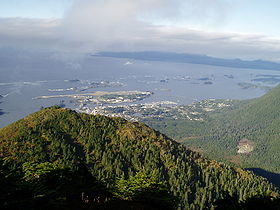
Mount Verstovia with Sitka and Sitka Sound in the background.Elevation 2,550 ft (777 m) Prominence 300 (91 m) – roughly Location Location Baranof Island, Alaska Coordinates 57°03′32″N 135°15′53″W / 57.05889°N 135.26472°W Topo map USGS Sitka Climbing Easiest route Hike Mount Verstovia is a colloquially referred to 2,550 foot (777 meter) mountain southwest of downtown Sitka, Alaska on Baranof Island which, according USGS maps, is really an unnamed peak.
History on name
Mount Verstovia was named Gora Verstovaya in 1809 by navigator Ivan Vasilyev (the first); with the etymology coming from verst — a Russian unit of distance equivalent .6629 miles.[1]
Mount Verstovia on USGS maps is actually unnamed, with the real Mount Verstovia colloquially known as Arrowhead
Access and recreation
Mount Verstovia is accessible by a well-maintained public trail that, through a number of switchbacks, arrives at the top. An unmaintained trail continues on from the peak to the real Mount Verstovia or the colloquial Mount Arrowhead.
Snowboarding, skiing, and other winter sports are very popular in the bowl east of the mountain and the trail to the summit is marked with reflective signs on tree trunks to help snow aficionados find their way up in snowy conditions.
References
- ^ Orth, Donald J. (1967). Dictionary of Alaska Place Names, Geological Survey, Professional Paper 567. Washington: United States Government Printing Office.
Categories:- Mountains of Alaska
- Landforms of Sitka City and Borough, Alaska
- Southeast Alaska geography stubs
Wikimedia Foundation. 2010.
