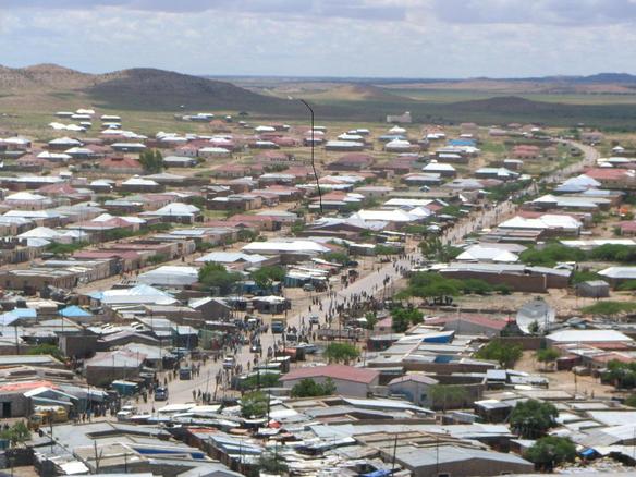
- Las Anod
Infobox Settlement
official_name = Las Anod
other_name =
native_name =
nickname =
settlement_type =
motto =
imagesize = 300px
image_caption =
flag_size =
image_
seal_size =
image_shield =
shield_size =
image_blank_emblem =
blank_emblem_type =
blank_emblem_size =
mapsize =
map_caption =
mapsize1 =
map_caption1 =
image_dot_
dot_mapsize =
dot_map_caption =
dot_x = |dot_y =
pushpin_
pushpin_mapsize =300
pushpin_label_position =bottom
pushpin_map_caption =Location in Somalia
subdivision_type = Country
subdivision_name = flag|Somalia
subdivision_type1 = Region
subdivision_name1 =Sool
subdivision_type2 = District
subdivision_name2 =
subdivision_type3 =
subdivision_name3 =
subdivision_type4 =
subdivision_name4 =
government_footnotes =
government_type =
leader_title =
leader_name =
leader_title1 =
leader_name1 =
leader_title2 =
leader_name2 =
leader_title3 =
leader_name3 =
leader_title4 =
leader_name4 =
established_title =
established_date =
established_title2 =
established_date2 =
established_title3 =
established_date3 =
area_magnitude =
unit_pref =Imperial
area_footnotes =
area_total_km2 =
area_land_km2 =
area_water_km2 =
area_total_sq_mi =
area_land_sq_mi =
area_water_sq_mi =
area_water_percent =
area_urban_km2 =
area_urban_sq_mi =
area_metro_km2 =
area_metro_sq_mi =
area_blank1_title =
area_blank1_km2 =
area_blank1_sq_mi =
population_as_of =
population_footnotes =
population_note =
population_total =
population_density_km2 =
population_density_sq_mi =
population_metro =
population_density_metro_km2 =
population_density_metro_sq_mi =
population_urban =
population_density_urban_km2 =
population_density_urban_sq_mi =
population_blank1_title =
population_blank1 =
population_blank2_title =
population_blank2 =
population_density_blank1_km2 =
population_density_blank1_sq_mi =
latd=8|latm=28|lats=32|latNS=N
longd=47|longm=21|longs=30|longEW=E
timezone =East Africa Time
utc_offset = +3
timezone_DST =
utc_offset_DST =
elevation_footnotes =
elevation_m =
elevation_ft =
postal_code_type =
postal_code =
area_code =
blank_name =
blank_info =
blank1_name =
blank1_info =
website =
footnotes =Las Anod [ [http://allafrica.com/stories/200710151934.html allAfrica.com: Somalia: Over 20 People Killed in Fresh Fighting Between Somaliland And Puntland States (Page 1 of 1) ] ] ( _so. "Laascaanood") is the administrative capital of
Sool region ofSomalia . The city was part of the formerBritish Somaliland Protectorate , which gained independence from theUnited Kingdom on26 June 1960 .Laascaanood is one of the largest cities in
Somalia , having grown from 20,000 to 60,000 residents between 1990 and 2001. [Cite web|url=http://www.reliefweb.int/rw/rwb.nsf/AllDocsByUNID/40d7a24abc52d97849256d60001f4bcc|title=Lasanood town urban vulnerability update 7 Jul 2003|accessdate=2007-04-18|work=ReliefWeb]The over whelming majority of inhabitants belong to the
Dulbahante clan [ [http://www.wardheernews.com/articles_07/october/21_Somaliland_Faisal_Roble.html “Somaliland: Is Invading Los Anod Part of Creating “New Reality on the Ground”? ] ] .Laascaanood is the type locality for
Dorstenia gypsophila.See also
*
Somaliland-Puntland dispute References
Wikimedia Foundation. 2010.

