- Moudros
-
Moudros
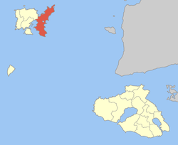
ΜούδροςLocation Coordinates 39°52′N 25°16′E / 39.867°N 25.267°ECoordinates: 39°52′N 25°16′E / 39.867°N 25.267°E Government Country: Greece Region: North Aegean Regional unit: Lemnos Municipality: Lemnos Population statistics (as of 2001) Municipal unit - Population: 4,842 - Area: 185.1 km2 (71 sq mi) - Density: 26 /km2 (68 /sq mi) Other Time zone: EET/EEST (UTC+2/3) Auto: MY Moudros (Greek: Μούδρος) is a town and a former municipality on the island of Lemnos, North Aegean, Greece. Since the 2011 local government reform it is part of the municipality Lemnos, of which it is a municipal unit.[1] It covers the entire eastern peninsula of the island, with a land area of 185.127 km², covering 38.8% of the island's territory. The municipal seat was the town of Moúdros (pop. 1,039). Its next largest town is Kontopoúli (661). The municipal unit's total population was 4,842 in the 2001 census. In 1918, it was the site of the signing of the Armistice of Mudros, which saw the end of hostilities between the Ottoman Empire and the Allies.
Subdivisions
The municipal unit Moudros is subdivided into the following communities (constituent villages in brackets):
- Fisini (Fisini, Agia Sofia)
- Kalliopi
- Kaminia (Kaminia, Voroskopos)
- Kontopouli (Kontopouli, Agios Alexandros, Agios Theodoros)
- Lychna (Lychna, Anemoessa)
- Moudros (Moudros, Koukonisi)
- Panagia (Panagia, Kortisonas)
- Plaka
- Repanidi (Repanidi, Kotsinos)
- Roussopouli
- Romano
- Skandali
External links
References
- ^ Kallikratis law Greece Ministry of Interior (Greek)
Municipal unit of Atsiki Municipal unit of Moudros Fisini · Kalliopi · Kaminia · Kontopouli · Lychna · Moudros · Panagia · Plaka · Repanidi · Roussopouli · Romano · SkandaliMunicipal unit of Myrina Municipal unit of Nea Koutali Categories:- Greece geography stubs
- Populated places in Lemnos
Wikimedia Foundation. 2010.


