Lexington-Fayette-Frankfort-Richmond, KY Combined Statistical Area
- Lexington-Fayette-Frankfort-Richmond, KY Combined Statistical Area

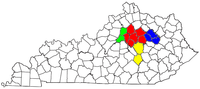
thumb|right|300px|Location of the Lexington-Fayette-Frankfort-Richmond CSA and its components:The Lexington-Fayette-Frankfort-Richmond, KY Combined Statistical Area, created by the United States Bureau of the Census in 2000, is the 76th largest Combined Statistical Area (CSA) of the United States. [ [http://www.census.gov/population/cen2000/phc-t29/tab06.xls Population in Combined Statistical Areas (CSAs) in Alphabetical Order and Numerical and Percent Change for the United States and Puerto Rico: 1990 and 2000] ] It consists of the Lexington-Fayette, KY Metropolitan Statistical Area (MSA) and the Micropolitan Statistical Areas (which is also abbreviated as MSA) of Frankfort, Kentucky, Mount Sterling, and Richmond-Berea.
• Populations are based upon published estimates by the United States Bureau of the Census.
¹Census defined area did not exist during this Census. Population totals are for counties included in 2005 Census MSA or CSA estimates. Population is shown for comparison purposes only and should not be used as a reference.
References
External links
* [http://www.census.gov/econ/census02/maps/metro/33000us336m.pdf Lexington-Fayette-Frankfort-Richmond, KY Combined Statistical Area (2003) map]
* [http://quickfacts.census.gov/qfd/ U.S. Census Bureau State & County QuickFacts]
* [http://www.census.gov/popest/estimates.php U.S. Census Bureau population estimates]
* [http://www.census.gov/population/www/estimates/metroarea.html Metropolitan and Micropolitan Statistical Areas]
* [http://www.census.gov/population/www/estimates/aboutmetro.html About Metropolitan and Micropolitan Statistical Areas]
* [http://www.census.gov/population/www/estimates/pastmetro.html Historical Metropolitan Area Definitions]
* [http://www.census.gov/population/www/estimates/masrp.html Metropolitan Area Standards Review Project (MASRP)]
* [http://www.policom.com/combined.htm Combined Statistical Areas]
Wikimedia Foundation.
2010.
Look at other dictionaries:
Lexington-Fayette, KY Metropolitan Statistical Area — The Lexington Fayette, KY Metropolitan Statistical Area is the 109th largest Metropolitan Statistical Area (MSA) in the United States. It was originally formed by the United States Census Bureau in 1950 and consisted solely of Fayette County… … Wikipedia
Lexington, Kentucky — Lexington Consolidated city county Lexington Fayette Urban County … Wikipedia
Corbin-London, KY Combined Statistical Area — Location of the Corbin London CSA and its components: Corbin Micropolitan Statistical Area … Wikipedia
Corbin, KY Micropolitan Statistical Area — Map highlighting the Corbin Micropolitan Statistical Area. The Corbin Micropolitan Statistical Area, as defined by the United States Census Bureau, is an area consisting of Whitley County, Kentucky, anchored by the Whitley County portion of the… … Wikipedia
Frankfort, Kentucky — Infobox Settlement official name = Frankfort, Kentucky settlement type = City nickname = motto = imagesize = 250px image caption = State Capitol image mapsize = 250px map caption = Location of Frankfort, Kentucky mapsize1 = map caption1 =… … Wikipedia
Frankfort, Kentucky micropolitan area — The Frankfort Micropolitan Statistical Area, as defined by the United States Census Bureau, is an area consisting of two counties in central Kentucky, anchored by the city of Frankfort. As of the 2000 census, the μSA had a population of 66,798… … Wikipedia
Richmond-Berea micropolitan area — The Richmond–Berea Micropolitan Statistical Area, as defined by the United States Census Bureau, is an area consisting of two counties in Kentucky, anchored by the cities of Richmond and Berea. As of the 2000 census, the μSA had a population of… … Wikipedia
Table of United States Metropolitan Statistical Areas — An enlargeable map of the 942 Core Based Statistical Areas (CBSAs) of the United States. The 367 Metropolitan Statistical Areas (MSAs) are shown in red. Main articles: Metropolitan Statistical Area and Core Based Statistical Area … Wikipedia
Mount Sterling micropolitan area — Map of the Lexington Fayette Frankfort Richmond CSA, with the Mount Sterling Micropolitan Statistical Area highlighted in blue The Mount Sterling Micropolitan Statistical Area, as defined by the United States Census Bureau, is an area consisting… … Wikipedia
Owensboro metropolitan area — Owensboro, KY ( IN) Metropolitan Statistical Area Common name: Owensboro Metro, Tri State Area Largest city Owensboro … Wikipedia

