Mosedale Beck

Mosedale Beck
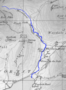
A map of Mosedale Beck (shown in blue) from 1925

Mosedale Beck is a stream in Cumbria which runs into Wast Water, which is the deepest lake in England.

Mosedale Beck rises in Little Scoat Fell, it then flows south west until it reaches Risson's Force waterfall, it then turns to the south and flows through the village of Wasdale Head. It then flows through Down-in-the-Dale where it is joined by Lingmell Beck before it empties into Wast Water

Tributaries

  • Gatherstone Beck
  • Black Beck
  • Fogmire Beck
  • Lingmell Beck

Coordinates: 54°27′30″N 3°15′39″W / 54.4582°N 3.2608°W / 54.4582; -3.2608


Wikimedia Foundation. 2010.

Игры ⚽ Нужен реферат?

Look at other dictionaries:

  • Red Pike (Wasdale) — Infobox Mountain Name = Red Pike (Wasdale) Elevation = 826 m, (2,709 ft) Location = Cumbria, ENG Range = Lake District, Western Fells Topographic OS Landranger 89, Explorer OL4, OL6 Prominence = c. 62 m Grid ref UK = NY165105 Listing = Wainwright …   Wikipedia

  • Hen Comb — Infobox Mountain Name=Hen Comb Photo = Caption = Location = Cumbria, ENG Range = Lake District, Western Fells Elevation = 509 m (1,670 ft) Prominence = c. 145 m Topographic OS Landranger 89, 90, Explorer OL4 Grid ref UK = NY133181 Listing =… …   Wikipedia

  • Cockermouth, Keswick and Penrith Railway — [v · d · …   Wikipedia

  • Tarn Crag (Far Eastern Fells) — Infobox Mountain Name = Tarn Crag (Far Eastern Fells) Photo = Caption = Elevation = 664 m (2,178 ft) Location = Cumbria, ENG Range = Lake District, Far Eastern Fells Prominence = c . 160 m Parent peak = High Street Coordinates = Topographic OS… …   Wikipedia

  • Liste des cours d'eau d'Angleterre — Cet article présente une liste des cours d eau d Angleterre, classés par position géographique dans le sens inverse des aiguilles d une montre. Ils passent par l Angleterre et se jettent dans les mers qui bordent le pays. Pour l Esk, la Tweed, la …   Wikipédia en Français

  • List of Sites of Special Scientific Interest in Cumbria — This is a list of the Sites of Special Scientific Interest (SSSIs) in Cumbria. For other counties, see List of SSSIs by Area of Search.* Alston Shingle Banks * Annaside * Annaside And Gutterby Banks * Appleby Fells * Argill Woods And Pastures *… …   Wikipedia

  • Wast Water — Distinguish from waste water. Infobox lake lake name = Wast Water image lake = Wast water.jpeg caption lake = Looking Towards Wasdale Head image bathymetry = Wast watercroped.jpg caption bathymetry = Map of 1925 location = England coords =… …   Wikipedia

  • Wast Water — País …   Wikipedia Español

  • River Glenderamackin — The River Glenderamackin is a river in the county of Cumbria, England.The river rises on Mungrisedale Common and drains much of the eastern and southern sides of Blencathra.The river runs east, then north before sharply turning south at the… …   Wikipedia

  • Wast Water — gegen Great Gable Geographische Lage Lake District Zuflüsse Mosedale Beck und andere …   Deutsch Wikipedia

Share the article and excerpts

Direct link
Do a right-click on the link above
and select “Copy Link”