- Incahuasi
-
This article is about a volcano on the border between Argentina and Chile. For other uses, see Incahuasi (disambiguation).
Incahuasi 
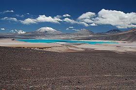
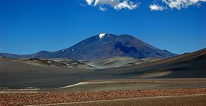
The volcanoes Incahuasi (left) and El Fraile behind the colorful Laguna Verde.Elevation 6,621 m (21,722 ft) Location Location Argentina-Chile Range Andes Coordinates 27°02′S 68°18′W / 27.033°S 68.3°W Geology Type stratovolcanoes and caldera Last eruption Unknown Climbing First ascent 1913 by Walther Penck Incahuasi or Nevado de Incahuasi is a mountain between the Argentine province of Catamarca, and the Atacama Region of Chile. Located at approximate coordinates 27°02′S 68°18′W / 27.033°S 68.3°W, it has a height of 6,621m.
The volcano consists of a 3.5 km wide caldera and two stratovolcanoes. Four pyroclastic cones are located 7 km to NE and produced basalt-andesite lava flows that cover an area of 10 km2.[1]
See also
- List of volcanoes in Chile
- List of volcanoes in Argentina
- Ojos del Salado
- Nevado Tres Cruces
- Cerro El Muerto
References
External links
- "Incahuasi". SummitPost.org. http://www.summitpost.org/page/154000.
- Incahuasi (Spanish)
Categories:- Geography of Atacama Region
- Mountains of Argentina
- Mountains of Chile
- Volcanoes of Argentina
- Volcanoes of Chile
- Geography of Catamarca Province
- Polygenetic volcanoes
- Argentina–Chile border
- International mountains of South America
- Catamarca Province geography stubs
- Chile geography stubs
Wikimedia Foundation. 2010.

