Wamel

Wamel

Dutch town locator maps
mun_


town_


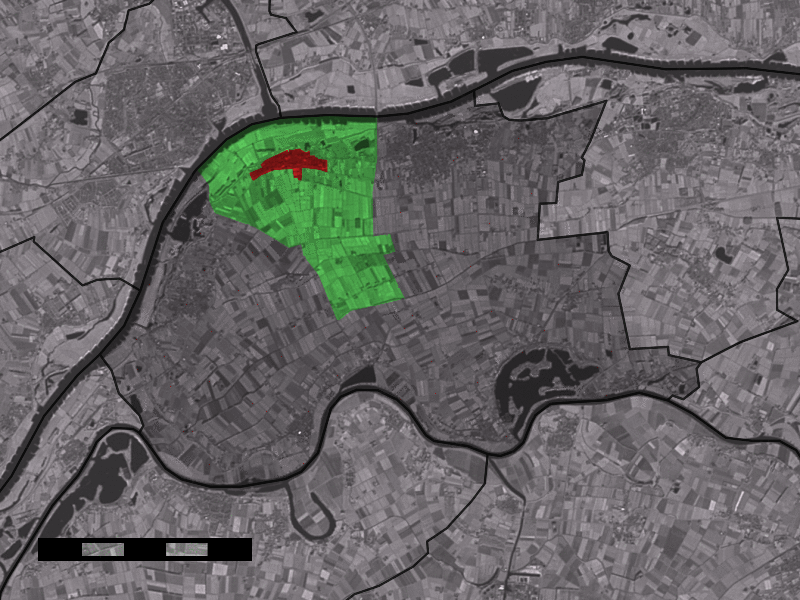
caption = The town centre (red) and the statistical district (light green) of Wamel in the municipality of West Maas en Waal.

Wamel (coord|51|53|N|5|28|E|type:city(1825)) is a town in the Dutch province of Gelderland. It is a part of the municipality of West Maas en Waal, and lies about 3 km east of Tiel.

Wamel was a separate municipality until 1984, when it merged with Appeltern and Dreumel. The new municipality was first called "Wamel", but the name changed to "West Maas en Waal" in 1985. [Ad van der Meer and Onno Boonstra, "Repertorium van Nederlandse gemeenten", KNAW, 2006. [http://www.knaw.nl/cfdata/publicaties/detail.cfm?boeken__ordernr=20061061] ]

In 2001, the town of Wamel had 1825 inhabitants. The built-up area of the town was 0.64 km², and contained 699 residences.Statistics Netherlands (CBS), [http://www.cbs.nl/nl-NL/menu/themas/milieu-natuur-ruimte/ruimte/publicaties/cartografie-geografie/geografische-data/2001-bevolkingskernen-in-nederland.htm "Bevolkingskernen in Nederland 2001"] . (Statistics are for the continuous built-up area).] The statistical area "Wamel", which also can include the peripheral parts of the village, as well as the surrounding countryside, has a population of around 2360.Statistics Netherlands (CBS), [http://statline.cbs.nl/ "Statline: Kerncijfers wijken en buurten 2003-2005"] . As of January 1, 2005.]

More about Wamel: http://www.wamel.net

People born in Wamel

*Ivo Den Bieman (born 1967), footballer

References


Wikimedia Foundation. 2010.

Игры ⚽ Поможем написать реферат

Look at other dictionaries:

  • Wamel — Gemeinde Möhnesee Koordinaten: 51°  …   Deutsch Wikipedia

  • wamel — wamel(l, wament see wamble, wayment …   Useful english dictionary

  • Wamel — 51°52′48″N 5°28′9″E / 51.88, 5.46917 …   Wikipédia en Français

  • wamell — wamel(l, wament see wamble, wayment …   Useful english dictionary

  • wament — wamel(l, wament see wamble, wayment …   Useful english dictionary

  • Liste der Gemeinden Westfalens O-Z — Diese Liste enthält alle Gemeinden Westfalens mit ihren Gebietsveränderungen ab 1858. Die Gemeinden des lippischen Landesteils werden erst ab ihrer Zugehörigkeit zum Land Nordrhein Westfalen mit ihren Gebietsänderungen aufgeführt. Die Zahlen in… …   Deutsch Wikipedia

  • Liste der ehemaligen Gemeinden in Gelderland — Hierunter folgt eine Liste der ehemaligen gelderschen Gemeinden. Wenn das Gebiet einer aufgehobenen Gemeinde über mehrere Gemeinden verteilt worden ist, ist das Großteil der erstgenannten Gemeinde hinzugefügt. Grenzkorrekturen zwischen erhaltenen …   Deutsch Wikipedia

  • Liste der ehemaligen Gemeinden in der Provinz Gelderland — Hierunter folgt eine Liste der ehemaligen gelderschen Gemeinden. Wenn das Gebiet einer aufgehobenen Gemeinde über mehrere Gemeinden verteilt worden ist, ist das Großteil der erstgenannten Gemeinde hinzugefügt. Grenzkorrekturen zwischen erhaltenen …   Deutsch Wikipedia

  • Möhnesee (Gemeinde) — Wappen Deutschlandkarte …   Deutsch Wikipedia

  • Bahnstrecke Brilon–Soest — Brilon–Soest Kursbuchstrecke (DB): ex 232n 1958 Streckennummer: 9217 9218 Streckenlänge: 53,2 km Spurweite: 1435 mm (Normalspur) Legende …   Deutsch Wikipedia

Share the article and excerpts

Direct link
Do a right-click on the link above
and select “Copy Link”