Nederhemert

Nederhemert
Nederhemert
—  Village  —
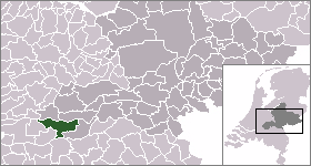
Coat of arms
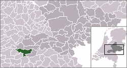
The village (red) and the statistical district (light green) of Nederhemert in the municipality of Zaltbommel.
Coordinates: 51°45′46″N 5°9′42″E / 51.76278°N 5.16167°E / 51.76278; 5.16167Coordinates: 51°45′46″N 5°9′42″E / 51.76278°N 5.16167°E / 51.76278; 5.16167
Country Netherlands
Province Gelderland
Municipality Zaltbommel
Population (1 January 2010)
 - Total 1,518
Time zone CET (UTC+1)
 - Summer (DST) CEST (UTC+2)
Postal code

Nederhemert is a village in the Dutch province of Gelderland. It is a part of the municipality of Zaltbommel, and lies about 8 km southwest of that city.

Nederhemert was a separate municipality until 1955, when it was merged with Kerkwijk.[1]

The village Nederhemert has a population of around 1370.[2] The statistical area "Nederhemert", which also can include the surrounding countryside, has a population of around 1500.[2]

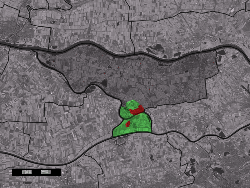
Nederhemert consists of two parts. The largest part is Nederhemert-Noord. The smaller village of Nederhemert-Zuid, with only about 45 inhabitants, lies south of the Afgedamde Maas.

References

  1. ^ Ad van der Meer and Onno Boonstra, Repertorium van Nederlandse gemeenten, KNAW, 2006.
  2. ^ a b Statistics Netherlands (CBS), Statline: Kerncijfers wijken en buurten 2003-2005. As of 1 January 2005.

External links


Wikimedia Foundation. 2010.

Игры ⚽ Поможем написать реферат

Look at other dictionaries:

  • Nederhemert —  Cette page d’homonymie répertorie les différents lieux partageant un même toponyme.  Pays Bas Nederhemert Noord, village de la commune de Zaltbommel, sur la rive droite de l Afgedamde Maas Nederhemert …   Wikipédia en Français

  • Nederhemert — Original name in latin Nederhemert Name in other language State code NL Continent/City Europe/Amsterdam longitude 51.76518 latitude 5.16817 altitude 3 Population 1496 Date 2009 01 09 …   Cities with a population over 1000 database

  • Nederhemert-Noord — Original name in latin Nederhemert Noord Name in other language Nederhemert Noordzijde, Nederhemert Noord State code NL Continent/City Europe/Amsterdam longitude 51.76322 latitude 5.17305 altitude 4 Population 1490 Date 2012 01 17 …   Cities with a population over 1000 database

  • Château de Nederhemert — Le château de Nederhemert Nom local Kasteel Nederhemert Site web www.kasteelnederhemert.nl/ Coordonnées …   Wikipédia en Français

  • Bommelerwaard — Situation du Bommelerwaard Le Bommelerwaard est une région naturelle des Pays Bas, située dans le sud ouest de la province du Gueldre. La région a une superficie d environ 147,6 km² et compte environ 48 000 habitants (1999). La circonférence …   Wikipédia en Français

  • Oensel (Gueldre) — Zaltbommel Zaltbommel …   Wikipédia en Français

  • Zaltbommel — Héraldique …   Wikipédia en Français

  • List of castles in the Netherlands — This is a list of castles in the Netherlands per province. Castles with existing parts from the Middle Ages are Antique White. Contents 1 Overview of castles in the Netherlands 1.1 Friesland 1.2 Groningen 1.3 …   Wikipedia

  • Liste der ehemaligen Gemeinden in der Provinz Gelderland — Hierunter folgt eine Liste der ehemaligen gelderschen Gemeinden. Wenn das Gebiet einer aufgehobenen Gemeinde über mehrere Gemeinden verteilt worden ist, ist das Großteil der erstgenannten Gemeinde hinzugefügt. Grenzkorrekturen zwischen erhaltenen …   Deutsch Wikipedia

  • Bern (Zaltbommel) — 51°44′54″N 5°9′55″E / 51.74833, 5.16528 …   Wikipédia en Français

Share the article and excerpts

Direct link
Do a right-click on the link above
and select “Copy Link”