- Canton Viaduct
Infobox_Bridge
bridge_name=Canton Viaduct
caption=
official_name=
crosses=Canton River
carries=
locale=Canton, Massachusetts
design=Stone archviaduct
mainspan=
length=615 feet
width=22 feet
below=
open=1835
maint=
id=
coordinates=
lat=42.158767
long=-71.153934
clearance=
traffic=
closed=
toll=
map_cue=
map_
map_text=
map_width=Canton Viaduct is a stone
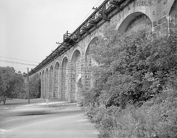
viaduct that spans theNeponset River inCanton, Massachusetts . It was built in 1835 byBoston and Providence Railroad and was designed byCaptain William Gibbs McNeill and MajorGeorge Washington Whistler , the father of the well-known painter,James McNeill Whistler .The bridge resembles a giant stone wall, with a maximum height of 70 feet. The Canton River, a tributary of the
Neponset River , passes through six small arches at the bottom of the bridge. A large waterfall comes from underneath the river, and a small stone bridge resembling the viaduct is further up, behind the viaduct, over the Canton River. The coping is supported by several segmental arches that join the tops of the buttresses. The structure is not one solid bridge, but is actually comprised of two parallel walls, each five feet thick, with a gap of five feet between the walls. After the bridge was originally built, a second track was added in 1860. In 1910, the roadbed was widened by adding cantilevering off of the main structure, and an opening was cut for a street in 1952. More recently, theMassachusetts Bay Transportation Authority rehabilitated the bridge forAmtrak 's high-speedAcela train service.The bridge is listed on the
National Register of Historic Places and theList of historic civil engineering landmarks .References
*
*cite web
url = http://hdl.loc.gov/loc.pnp/hhh.ma1199
title = Canton Viaduct
format =
work = Historic American Engineering Record
publisher = National Park Service
accessdate = 2006-07-02
accessyear =
*
*
Wikimedia Foundation. 2010.
