Cape Fear Memorial Bridge
- Cape Fear Memorial Bridge
Infobox_Bridge
bridge_name=Cape Fear Memorial Bridge
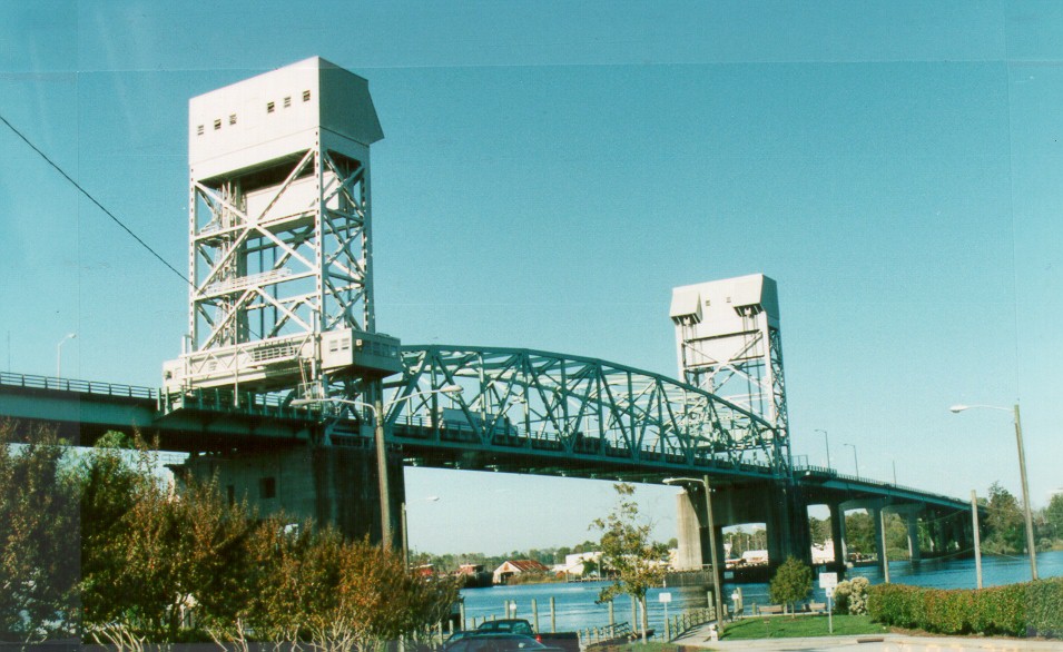
caption=
official_name=Cape Fear Memorial Bridge
locale=Wilmington, North Carolina
carries=Bus US 17/US 74/76/421
crosses=Cape Fear River
Average Daily Traffic= 64,000 Vehicles
id=unknown
maint=North Carolina Department of Transportation
open= October 1, 1969
Lanes on Structure= 4
below=21 m (68.9 ft)
design=Lift bridge
length=924.5 m (3,033.1 ft)
Bridge Roadway Width= 16.5 m (54.1 ft)
Operating Rating= 46.8 Metric Tons
Sufficiency rating= 47.9 (out of 100)
lat=34.2280
long=-77.9521The Cape Fear Memorial Bridge is a steel vertical lift bridge. This bridge type lifts the main span to allow passage of large ships. It crosses the Cape Fear River between Brunswick County, North Carolina and New Hanover County, North Carolina. It is used by U.S. Highway 17 Business, U.S. Highway 74, U.S. Highway 76, and U.S. Highway 421 for traffic coming from Brunswick County and Myrtle Beach, South Carolina. Constructed in 1969, it is currently the highest bridge in North Carolina and replaced a 1929 bridge (which was removed) across the Northeast Cape Fear River, near where the Isabel Stellings Holmes Bridge carrying NC 133 is today. Between May and August 2008, the bridge is undergoing repairs of cracks in its decking. Because the bridge is narrow and carries much more traffic than when it was built, it is considered functionally obsolete by the North Carolina Department of Transportation.
There has been discussion of a new bridge across the Cape Fear River downstream from downtown Wilmington. However, the Cape Fear Skyway remains in the early planning stage.
ee also
*Interstate 140 (North Carolina)
*USS North Carolina (BB-55)
External links
*
References
* " [http://bridgepros.com/bridge_records/usabridgerecords.htm State Bridge Records] " Accessed June 30, 2006.
Wikimedia Foundation.
2010.
Look at other dictionaries:
Cape Fear River — Map of the Cape Fear River drainage basin Origin North Carolina Mouth Atlantic Ocean … Wikipedia
Memorial Bridge (disambiguation) — Memorial Bridge refers to a number of bridges around the world:In the United States: * Abraham Lincoln Memorial Bridge, connecting La Salle and Oglesby, Illinois * Alfred H. Smith Memorial Bridge, Castleton on Hudson, New York * American Legion… … Wikipedia
Memorial Bridge — Contents 1 United States 2 Canada 3 Republic of Ireland 4 … Wikipedia
Vertical lift bridge — BridgeTypePix image title= type name=Vertical lift bridge|sibling names=Bascule bridge, swing bridge, folding bridge, retractable bridge descendent names=Submersible bridge, table bridge ancestor names=Truss bridge, carries=Automobile,… … Wikipedia
Schlacht von Moores Creek Bridge — Moores Creek National Battlefield Rekonstruierte Erdwälle als Brustwehr der Patrioten in der Schlacht … Deutsch Wikipedia
List of bridges in the United States — Bridges in the United States is a link page for any notable bridge in the United States of America.See: List of bridges AlabamaTen bridges in Alabama meet standards of national historical significance and are included on List of bridges on the… … Wikipedia
Bannered routes of U.S. Route 17 — A total of at least ten bannered routes of U.S. Route 17 exist.avannah, Georgiausban route=17 banner=ALT location=Savannah, GeorgiaU.S. Route 17 Alternate in Savannah, Georgia was a route that existed from the 1950s to the 1990s. The route was… … Wikipedia
Lattice girder — Darcy Lever lattice girder railway bridge, Lancashire … Wikipedia
U.S. Route 76 — Route information Length … Wikipedia
Lighthouses in the United States — This United States has hundreds of lights as well as light towers, range lights, and pier head lights. Michigan has the most lights of any state with over 130. See also: Lightvessels in the United States, lightvessel, List of lighthouses and… … Wikipedia