- Çıralı
-
Çıralı is an agricultural village in the southwest of Turkey in Antalya Province. It is close to the ancient ruins of Olympos and Chimaera permanent gas vents.
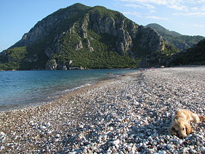
It is a very small rural village located just over an hour's drive southwest from Antalya and boasts a beautiful 3.5 km secluded beach, the ruins of Olympos, the flames of the Chimaera / Yanartaş, as well as being a protected area by the WWF for the nesting of Caretta, also known as loggerhead sea turtles.
Also near Çıralı is the Ulupınar region, which is rich in rivers and creeks. Cirali/Çıralı is one of the last unspoilt natural areas along the Antalya coastline.
For the intrepid trekkers, highlights of the Lycian Way with paths are also found in Çıralı. One runs from Çıralı to Tekirova (19 km) and another travels from Çıralı to Ulupınar and then back down to the flames of the Chimaera which is around 12 km. All these trails and paths are marked in red and white.
Another wonderful section of the Lycian Way (Likya Yolu) near Çıralı is the summit of Tahtalı Dag, also known as Mt. Olympos. It is located in the National Park of Olympos or Olimpos Bey Dağları Parkı.
There are no large hotels but numerous small places with accommodation, e.g., family run pensions.
Although close to Olympos it is not possible to drive between the road of Çıralı and the road to Olympos since they are separated by the beach and the ruins of Olympos.
External links
- Çıralı web site
- Çıralı Information and Guide.
- Çıralı Information
- About Cirali
- Çıralı Online
- WWF Caretta sea turtles
- Lycian Way - about the walk
- REPUBLIC OF TURKEY MINISTRY OF CULTURE AND TOURISM - Antalya - Beydaglari Shore National Park
Coordinates: 36°25′03″N 30°28′39″E / 36.4175°N 30.4775°E
Categories:- Antalya
- Turkish Riviera
- Villages in Turkey
- Mediterranean Region, Turkey geography stubs
Wikimedia Foundation. 2010.


