- Gaildorf
-
Gaildorf 

 GaildorfLocation of the town of Gaildorf within Schwäbisch Hall district
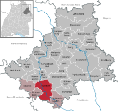

Coordinates 49°0′N 9°46′E / 49°N 9.76667°ECoordinates: 49°0′N 9°46′E / 49°N 9.76667°E Administration Country Germany State Baden-Württemberg Admin. region Stuttgart District Schwäbisch Hall Town subdivisions 10 Stadtteile Mayor Ralf Eggert Basic statistics Area 62.56 km2 (24.15 sq mi) Elevation 329 m (1079 ft) Population 12,332 (31 December 2010)[1] - Density 197 /km2 (511 /sq mi) Other information Time zone CET/CEST (UTC+1/+2) Licence plate SHA Postal code 74405 Area code 07971 Website www.gaildorf.de Gaildorf is a town in the district of Schwäbisch Hall, in Baden-Württemberg, Germany. It is located on the river Kocher, 13 km south of Schwäbisch Hall.
People
- Stefan Everts
- Hermann Frasch
Blaufelden | Braunsbach | Bühlertann | Bühlerzell | Crailsheim | Fichtenau | Fichtenberg | Frankenhardt | Gaildorf | Gerabronn | Ilshofen | Kirchberg an der Jagst | Kreßberg | Langenburg | Mainhardt | Michelbach an der Bilz | Michelfeld | Oberrot | Obersontheim | Rosengarten | Rot am See | Satteldorf | Schrozberg | Schwäbisch Hall | Stimpfach | Sulzbach-Laufen | Untermünkheim | Vellberg | Wallhausen | Wolpertshausen
References
- ^ "Bevölkerung und Erwerbstätigkeit" (in German). Statistisches Landesamt Baden-Württemberg. 31 December 2009. http://www.statistik-bw.de/Veroeffentl/Statistische_Berichte/3126_10001.pdf.
Categories:- Geography articles needing translation from German Wikipedia
- Towns in Baden-Württemberg
- Schwäbisch Hall district
- Stuttgart region geography stubs


Wikimedia Foundation. 2010.