- Vágur
Infobox Settlement
official_name = Vágur
other_name =
native_name =
nickname =
settlement_type =Town
motto =
imagesize =
image_caption = Typical dramatic light scenery in the Faroe Islands: The town of Vágur, winter 2004
flag_size =
image_
seal_size =
image_shield =
shield_size =
mapsize =
map_caption =
mapsize1 =
map_caption1 =
image_dot_
dot_mapsize =
dot_map_caption =
dot_x = |dot_y =
pushpin_
pushpin_label_position =
pushpin_map_caption =Location within the Faroe Islands
pushpin_mapsize =
subdivision_type = Country
subdivision_name = flag|Denmark
subdivision_type1 = Autonomous Province
subdivision_name1 = flag|Faroe Islands
subdivision_type2 = Municipality
subdivision_name2 = Vágs kommuna
subdivision_type3 =
subdivision_name3 =
subdivision_type4 =
subdivision_name4 =
government_footnotes =
government_type =
leader_title =
leader_name =
leader_title1 =
leader_name1 =
leader_title2 =
leader_name2 =
leader_title3 =
leader_name3 =
leader_title4 =
leader_name4 =
established_title =
established_date =
established_title2 =
established_date2 =
established_title3 =
established_date3 =
area_magnitude =
unit_pref =
area_footnotes =
area_total_km2 =
area_land_km2 =
area_water_km2 =
area_total_sq_mi =
area_land_sq_mi =
area_water_sq_mi =
area_water_percent =
area_urban_km2 =
area_urban_sq_mi =
area_metro_km2 =
area_metro_sq_mi =
area_blank1_title =
area_blank1_km2 =
area_blank1_sq_mi =
population_as_of =2007
population_footnotes =
population_note =
population_total =1402
population_density_km2 =
population_density_sq_mi =
population_metro =
population_density_metro_km2 =
population_density_metro_sq_mi =
population_urban =
population_density_urban_km2 =
population_density_urban_sq_mi =
population_blank1_title =
population_blank1 =
population_density_blank1_km2 =
population_density_blank1_sq_mi =
timezone =
utc_offset =
timezone_DST =
utc_offset_DST =
latd = 61 | latm = 28 | lats = 31 | latNS = N
longd = 6 | longm = 48 | longs = 26 | longEW = W
elevation_footnotes =
elevation_m =
elevation_ft =
postal_code_type = Postal code
postal_code =FO 900
area_code =
blank_name =
blank_info =
blank1_name =
blank1_info =
website =
footnotes =Vágur meaning "Bay" is a town on the
Faroe Island ofSuðuroy , it is situated on the east coast of the island on the Vágsfjørður fjord, and dates from the fourteenth century. Expansion has meant that the nearby town ofNes is now a suburb of Vágur. Vágur has a sports hall next to the football grounds, a swimmingpool by the school, a High School and a clinic which offers the services of doctors, nurses and dentists. There is also a hotel, Post Office, banks and various shops.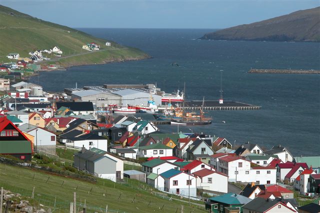
thumb|left|Vágur Church was built in 1937.The port area, which is 14 m in depth, is situated on the northern part of the fjord. The port authorities can offer services of piloting (lods), water and fire-fighting, and in connection with the harbour there is a very modern fish factory and auctioneers for fish.The town has a slipway, a fleet of fishing vessels and a filleting factory.The first hydroelectric power station in the Faroe Islands was built in Vágur in 1921. It is now supplemented by a modern diesel power station on the south side of the fjord.
There is a memorial near the main road through Vágur commemorating the efforts of
Nólsoyar Páll , the nineteenth-century Faroese hero, poet and genius. He believed that the monopoly trading scheme was seriously restricting the economic potential of the Faroe Islands and set about organising opposition and resistance to it. Although he failed to abolish the monopolies, his actions were the start of a process which eventually led to the abolition of monopoly trading in 1856.cite book | last = Swaney | first Deanna | title = Iceland, Greenland & the Faroe Islands | publisher =Lonely Planet Publications | edition = 3rd edition | origyear = 1991 | origmonth = February | year = 1997 | month = June | date = 1999 | id = ISBN 0864424531 ]Tourism
The tourist attractions indclude a wide variety of excursions during the summer. Amongst other things on offer is a boat trip on the old fishing boat, Jóhanna TG 326, west around the island to an area where birds flock and nest by the thousand, close to the world's steepest cliff,
Beinisvørð .The Ruth Smith Art Gallery in Vágur, Suðuroy (Suthern Island) doesn't have regular opening hours. If you wish to visit the art collection, please contact the local Tourist Information. The Ruth Smith Art Gallery is situated in the western part of the village of Vágur in a yellow building on the mainstreet Vágsvegur 101.
For visitors arriving by boat, Vágur is situated 61° 21' north and 06° 49' west.
* Soccer association: VB (Vágs Bóltfelag)
See also
*
List of towns in the Faroe Islands References

Wikimedia Foundation. 2010.