- Nu'utele
-
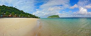
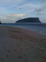
 Nu'utele island viewed from Lalomanu beach, 2007
Nu'utele is an island which consists of a volcanic tuff ring situated 1.3 km off the eastern end of Upolu island, Samoa. It is the largest of the four Aleipata Islands, at 1.08 km².
Together with Nu'ulua, a smaller isle in the Aleipata group, the two areas are significant conservation areas for native species of bird life. Nu'utele features steep terrain with vertical marine cliffs up to 180 m high.[1]
Nu'utele serves as a famous background scene for the popular Lalomanu beach area.
See also
- Samoa Islands
Notes
- "Upolu". Global Volcanism Program, Smithsonian Institution. http://www.volcano.si.edu/world/volcano.cfm?vnum=0404-03-. (includes Nu'utele)
- Some information about Nu'utele and Nu'ulua.
References
 Atua District: Itūmālō
Traditional center: Lufilufi Villages 
Landmarks · Falefa Valley · Piula Theological College · Piula Cave Pool ·Islands Aleipata Islands (uninhabited, conservation areas) Nu'utele, Nu'ulua, Namua, Fanuatapu · Nu'usafe'e IslandNotable people · Fiame Mata'afa Faumuina Mulinu’u II · Fiame Naomi Mata'afa · Lia Maivia · Tuilaepa Aiono Sailele Malielegaoi ·Environment · Samoan plant names · List of birds of Samoa · List of mammals of Samoa · List of protected areas of Samoa ·Electoral constituencies: Faipule Districts Aleipata Itupa i Lalo · Aleipata Itupa i Luga · Anoamaa East · Anoamaa West · Falealili (2 seats) · Lepa · LotofagaIslands of Samoa (Independent State of Samoa) Principal islands Small inhabited islands Uninhabited islands Coordinates: 14°03′47″S 171°25′23″W / 14.063°S 171.423°W
Categories:- Uninhabited islands of Samoa
- Volcanoes of Samoa
- Tuff cones
- Conservation in Samoa
- Biota of Samoa
- Samoa geography stubs
Wikimedia Foundation. 2010.

