- Janów Lubelski County
Infobox Settlement
name = Janów Lubelski County
native_name = Powiat janowski
settlement_type =
image_shield = POL powiat janowski COA.svg
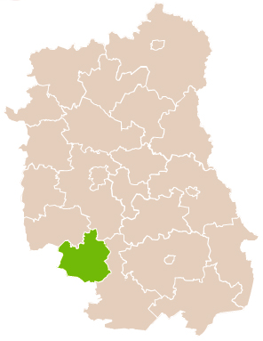
map_caption = Location within the voivodeship
subdivision_type = Country
subdivision_name = POL
subdivision_type1 = Voivodeship
subdivision_name1 = Lublin
area_total_km2 = 875.34
population_total = 47875
population_as_of = 2006
population_density_km2 = auto
population_urban = 11938
population_blank1_title = Rural
population_blank1 = 35937
coor_type = Janów Lubelski
latd = 50
latm = 43
lats =
latNS = N
longd = 22
longm = 25
longs =
longEW = E
seat =Janów Lubelski
parts_type =Gmina s
parts = Total 7
p1 =Gmina Batorz
p2 = Gmina Chrzanów
p3 =Gmina Dzwola
p4 =Gmina Godziszów
p5 =Gmina Janów Lubelski
p6 =Gmina Modliborzyce
p7 =Gmina Potok Wielki
blank_name = Car plates
blank_info = LJA
website = http://www.bip.powiatjanowski.pl/__NOTOC__Janów Lubelski County ( _pl. powiat janowski) is a unit of territorial administration and local government (powiat ) inLublin Voivodeship , easternPoland . It was created onJanuary 1 ,1999 as a result of the Local Government Reorganization Act of 1998. Its administrative seat and only town isJanów Lubelski , which lies convert|60|km|mi|0 south of the regional capitalLublin .The county covers an area of convert|875.34|km2|sqmi|1. As of 2006 its total population is 47,875, out of which the population of Janów Lubelski is 11,938 and the rural population is 35,937.
Neighbouring counties
Janów Lubelski County is bordered by
Kraśnik County andLublin County to the north,Biłgoraj County to the south-east,Nisko County to the south-west, andStalowa Wola County to the west.Administrative division
The county is subdivided into seven
gmina s (one urban-rural and six rural). These are listed in the following table, in descending order of population.References
* [http://www.stat.gov.pl/gus/45_655_PLK_HTML.htm Polish official population figures 2006]

Wikimedia Foundation. 2010.