- Lions' Gate Bridge
Infobox Bridge
bridge_name = Lions' Gate Bridge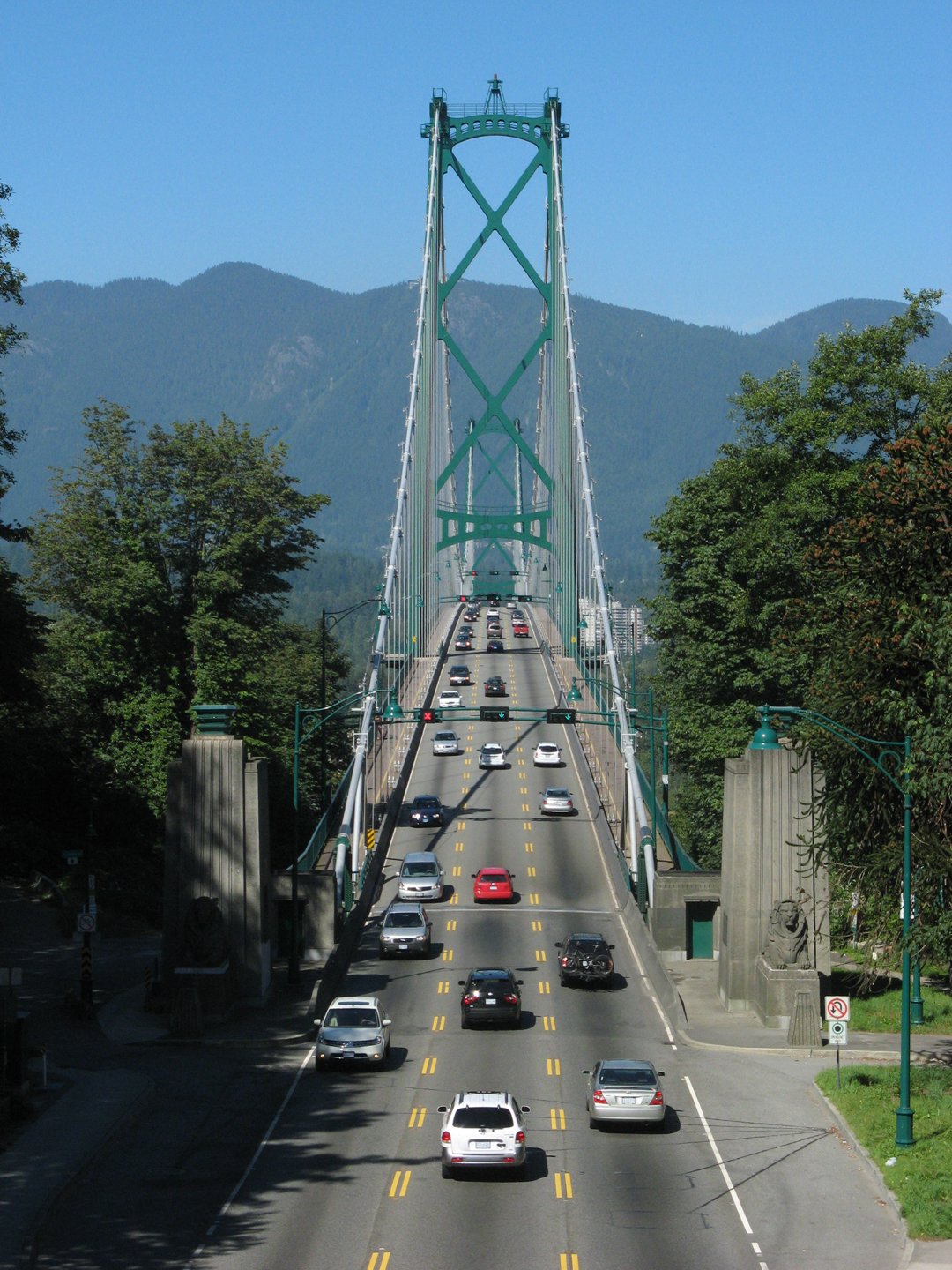
|100px
caption = Lions' Gate Bridge from the south end inStanley Park
official_name = First Narrows Bridge
carries = Automobiles, Pedestrians and Cyclists
crosses = Burrard Inlet
locale = North Vancouver, British Columbia
maint =
id =
design =
mainspan = 472 m (1,550 ft)
length = 1,823 metres (5,890 feet)
width =
height =
load = 13 tonnes (14.3 tons)
clearance =
below = 61 m (200 ft)
traffic = 60,000 - 70,000
begin = March 31, 1937
complete =
open = November 14, 1938
closed =
toll =
map_cue =
map_
map_text =
map_width =
coordinates =
lat =
long = Location map
Vancouver
lon_dir = W
lat_dir = N
lat_deg = 49
lat_min = 18
lat_sec = 55
lon_deg = 123
lon_min = 08
lon_sec = 18
caption = Location of Lions' Gate Bridge in Vancouver
width = 220Lions' Gate Bridge, officially known as the First Narrows Bridge, [ [http://www.qp.gov.bc.ca/statreg/reg/T/Transportation513_2004/513_2004.htm Transportation Act - PROVINCIAL PUBLIC UNDERTAKINGS REGULATION ] ] is a
suspension bridge that crosses the first narrows ofBurrard Inlet and connects the City ofVancouver ,British Columbia , to the North Shore municipalities of the District of North Vancouver, the City of North Vancouver, and West Vancouver. The term "Lions' Gate" reflects the Lions, a pair of mountain peaks north of Vancouver.The total length of the bridge including the north viaduct is 1,823
metre s (5,890 feet). The length including approach spans is 1,517.3 m (4,978 ft), the main span alone is 472 m (1,550 ft), the tower height is 111 m (364 ft), and it has a ship's clearance of 61 m (200 ft). Prospect Point inStanley Park offered a good high south end to the bridge, but the low flat delta land to the north required construction of the extensive North Viaduct.The bridge has three
reversible lane s, the use of which is indicated by signals. The centre lane changes direction to accommodate for traffic patterns. Thetraffic volume on the bridge is 60,000 - 70,000 vehicles per day. Trucks exceeding 13 tonnes (14.3 tons) are prohibited, as are vehicles using studded tires.The bridge forms part of Highways 99 and 1A.
History
Starting about
1890 , bridge builders foresaw the possibility that a bridge across the first narrows would open up. There were a number who argued against its construction, as many felt it would ruinStanley Park or cause problems for the busy seaport or that it would take toll revenue away from theSecond Narrows Bridge . However, many others saw it as necessary in order to open up development on the North Shore and it was felt that these problems could be overcome. The decision was put to the electorate of Vancouver in 1927, but the first plebiscite was defeated and the idea was put to rest for a short while.Alfred James Towle Taylor, who had been part of this proposal and still owned the provincial franchise to build the bridge, did not have the finances to purchase the necessary large sections of property in North Vancouver and West Vancouver. However, he was able to convince the
Guinness family (of the Irishbeer fame) to invest in the land on the north shore of Burrard Inlet. They purchased 4,700 acres (16 km²) of West Vancouver mountainside through a syndicate called British Pacific Properties Ltd.On
December 13 1933 , a second plebiscite was held and this time, it was passed by a 2 to 1 margin. After considerable further negotiations with the federal government, approval was finally granted, with the requirement that Vancouver materials and workmen be used as much as possible to provide employment during theGreat Depression .The bridge was designed by the
Montreal firm Monsarrat and Pratley, which was later responsible for theAngus L. Macdonald Bridge in Halifax,Construction began on
March 31 1937 . After one and a half years and a cost of $5,873,837.17 (CAD), it opened to traffic onNovember 14 1938 . OnMay 29 1939 ,King George VI and Queen Elizabeth presided over the official opening during a royal visit to Canada. A toll of 25 cents was charged for each car. OnJanuary 20 1955 , the Guinness family sold the bridge to the province for $5,959,060, and in 1963, the tolls were dropped.The bridge was originally constructed as a two-lane bridge, but when traffic increased, the road was repainted to create a third lane, which was originally a passing lane. Eventually overhead lane control signals were installed, enabling traffic in the centre lane to be directed in either direction.
In 1975, the deteriorating north viaduct was replaced with a lighter, wider, and stronger steel deck with wider lanes. This was carried out in sections using a series of short closures of the bridge; each time, one old section was lowered from the bridge and its replacement was put into place.
In 1986 the Guinness family, as a gift to Vancouver, purchased decorative lights that make it a distinctive nighttime landmark.
By the 1990s, it was time for the bridge to be either significantly upgraded or replaced. A number of different proposals were considered, including building a new bridge beside the existing bridge, building a tunnel from downtown Vancouver to the north shore, or double decking the existing bridge. However, none of the proposals could overcome the City of Vancouver's objections to any increase in traffic into the downtown core and the province's unwillingness to spend much money on the project. In the end, it was decided to upgrade the existing bridge without adding any new lanes.
Traffic was finding the 2.84 m (9 ft 4 in) wide lanes narrow, and the sidewalks were inadequate for pedestrians and cyclists. As a result, the main bridge deck was replaced in 2000 and 2001. As with the earlier work, this was facilitated by a series of separate nighttime and weekend closures to replace one section at a time. The old section would be lowered to a barge, and the new one raised into place and connected. The change allowed the two pedestrian walkways to be moved to the outside of the structure and the road lanes were accordingly widened from 3 to 3.6 m (from 10 to 12 ft) each; the new sidewalks are also wider, 2.7 m (9 ft) each instead of 1.2 m (4 ft). Also, the main structural elements were moved to below the bridge deck, thus giving a much more open appearance. The entire suspended structure was thus replaced with little or no interruption in daytime traffic [ [http://md1.csa.com/partners/viewrecord.php?requester=gs&collection=TRD&recid=2005082226164CE&q=bridge+design&uid=792876632&setcookie=yes Lions' Gate Suspension Bridge; Design of the Suspended Structure Replacement] ] .
Landmark
The Lions' Gate Bridge has become a landmark of Vancouver and the North Shore.
The bridge was featured on the first title card of CBC supper-hour newscast "
Canada Now ", but it was replaced with a local image in several markets.The bridge is often used in television broadcasts as a symbol of Vancouver; most telecasts of
NHL hockey games played in Vancouver show the bridge at least once.Gallery
ee also
*
The Lions (peaks)
*List of bridges in Canada
*List of bridges References
External links
* [http://www.mccord-museum.qc.ca/en/keys/webtours/GE_P4_3_EN.html Building a Vancouver Icon: The Lions Gate Bridge] — the construction of the Lions' Gate Bridge (illustrated with many photographs)
* [http://www.discovervancouver.com/GVB/vancouver-bridges.asp Bridges of Greater Vancouver]
*Crossings navbox
structure = Crossings
place =Burrard Inlet
bridge =Lions' Gate Bridge
bridge signs =
upstream text = West
upstream = English Bay
upstream signs =
downstream text = East
downstream =SeaBus
downstream signs =
Wikimedia Foundation. 2010.