Coëtivy Island

Coëtivy Island
Coëtivy Island. NASA Image
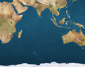
Coëtivy is located in Indian Ocean
{{{alt}}}
Coëtivy
Location of Coëtivy Island in the Indian Ocean

Coëtivy Island is a small coral island in the Seychelles 290 km south of Mahe, at 07°08′S 56°16′E / 7.133°S 56.267°E / -7.133; 56.267. Along with Île Platte, the nearest neighbor 171 km northwest, it comprises the Southern Coral Group and therefore belongs to the Outer Islands (Seychelles). Its area is 9.31 km² and it has a population of 252. It was named after by Chevalier de Coetivy who first sighted the island in 1771. Until 1908 it was politically part of Mauritius.

The island is privately owned by the paranatal Seychelles Marketing Board (SMB). Coetivy has recently been known for its shrimp farms (black tiger prawn) and shrimp processing plant that began in the early 1990s; (from 1989-1992 the business was in "development phase"). There is also some vegetable farming in which the produce is sold in markets on Mahe.

External links


Wikimedia Foundation. 2010.

Игры ⚽ Нужно сделать НИР?

Look at other dictionaries:

  • Coëtivy Airport — IATA: none – ICAO: FSSC …   Wikipedia

  • Coëtivy — Pour les articles homonymes, voir Coëtivy (homonymie). Coëtivy Île Coëtivy Image satellite de Coëtivy …   Wikipédia en Français

  • Compendium of postage stamp issuers (Ci — Each article in this category is a collection of entries about several stamp issuers, presented in alphabetical order. The entries are formulated on the micro model and so provide summary information about all known issuers. See the… …   Wikipedia

  • Geography of Seychelles — Map of Seychelles The Seychelles is a small island nation located in the Indian Ocean northeast of Madagascar and about 1,600 km (994 mi) east of Kenya. Seychelles lies between approximately 4ºS and 10ºS and 46ºE and 54ºE. The nation is …   Wikipedia

  • Compendium of postage stamp issuers (Ci - Co) — Each article in this category is in fact a collection of entries about several stamp issuers, presented in alphabetical order. The entries themselves are formulated on the micro model and so provide summary information about all known issuers.… …   Wikipedia

  • Outer Islands (Seychelles) — For other places with the same name, see Outer Island (disambiguation). The Outer Islands or Coralline Seychelles is a collective term for those islands of the Seychelles that are not on the shallow Seychelles Bank (Seychelles Plateau) which… …   Wikipedia

  • Southern Coral Group — is a collective term for two islands of Outer Islands of the Seychelles, lying in the south of the island nation, between 135 and 300 kilometers south of the capital, Victoria, on Mahé Island.Islands in the Southern Coral GroupTwo widely… …   Wikipedia

  • Île Platte — Île Platte, or Platte Island is 135 km south of Mahé, the main island of the Seychelles. At coord|05|52|S|55|24|E|, it is clearly south of the Seychelles Bank and belongs to the Outer Islands. Île Platte and Coëtivy Island, 171 km further… …   Wikipedia

  • Административное деление Сейшельских Островов — Республика Сейшельские Острова в административном отношении делятся на двадцать пять округов (англ. district), все они находятся на группе собственно Сейшельских островов, также называемых «Внутренними островами» или «гранитными островами».… …   Википедия

  • USS William R. Rush (DD-714) — For other ships of the same name, see USS William R. Rush. Career …   Wikipedia

Share the article and excerpts

Direct link
Do a right-click on the link above
and select “Copy Link”