- Phnom Bakheng
Infobox Mandir
creator =Yasovarman
proper_name = Phnom Bakheng
date_built = 889-910 A.D.
primary_deity =Shiva
architecture =Khmer
location =Angkor ,Cambodia Phnom Bakheng (
Khmer : ប្រាសាទភ្នំបាខែង) atAngkor ,Cambodia , is a Hindu temple in the form of a temple mountain. Dedicated toShiva , it was built at the end of the 9th century, during the reign of KingYasovarman (889-910 A.D.). Located atop a hill, it is nowadays a popular tourist spot for sunset views of the much bigger templeAngkor Wat , which lies amid the jungle about 1.5 km to the southeast. The large number of visitors makes Phnom Bakheng one of the most threatened monuments of Angkor. [http://observer.guardian.co.uk/world/story/0,,2020821,00.html?gusrc=rss&feed=travel]Constructed more than two centuries before Angkor Wat, Phnom Bakheng was in its day the principal temple of the Angkor region, historians believe. It was the architectural centerpiece of a new capital, Yasodharapura, that Yasovarman built when he moved the court from the capital
Hariharalaya in theRoluos area located to the southeast.An inscription dated 1052 A.D. and found at the
Sdok Kak Thom temple in present-dayThailand states inSanskrit : "When Sri Yasovardhana became king under the name of Yasovarman, the able Vamasiva continued as his guru. By the king's order, he set up a linga on Sri Yasodharagiri, a mountain equal in beauty to the king of mountains." [Sak-Humphry, "The Sdok Kak Thom Inscription" p. 38.] Scholars believe that this passage refers to the consecration of the Phnom Bakheng temple approximately a century and a half earlier.Surrounding the mount and temple, labor teams built an outer moat measuring about four kilometers square and 200 meters wide; its southwest sections are still visible from the air. The new city probably lay largely within the confines of this moat. A smaller inner moat measuring 650 by 436 meters was also constructed. Avenues radiated out in the four cardinal directions from the mount. A causeway ran in a northwest-southeast orientation from the old capital area to the east section of the new capital's outer moat and then, turning to an east-west orientation, connected directly to the east entrance of the temple. [Higham, "The Civilization of Angkor" p. 64.]
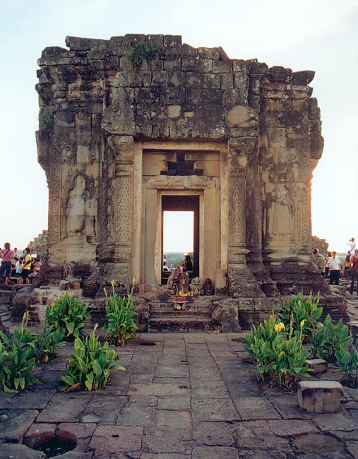
Phnom Bakheng is a symbolic representation of
Mount Meru , home of theHindu gods, a status emphasized by the temple’s location atop a steep hill. The temple faces east, measures 76 meters square at its base and is built in a pyramid form of six tiers. At the top level, five sandstone sanctuaries, in various states of repair, stand in a quincunx pattern--one in the center and one at each corner of the level’s square. Originally, 108 small towers were arrayed around the temple at ground level and on various of its tiers; most of them have collapsed. [Rooney, "Angkor" p. 236.]Phnom Bakheng is one of three hilltop temples in the Angkor region that are attributed to Yasovarman's reign. The other two are
Phnom Krom to the south near theTonle Sap lake, andPhnom Bok , northeast of theEast Baray reservoir.Following Angkor's rediscovery by the outside world in the mid-19th Century, decades passed before archeologists grasped Phnom Bakheng's historical significance. For many years, scholars' consensus view was that the
Bayon , the temple located at the center ofAngkor Thom city, was the edifice to which the Sdok Kak Thom inscription referred. Later work identified the Bayon as aBuddhist site, built almost three centuries later than originally thought, in the late 12th Century, and Phnom Bakheng as King Yasovarman's state temple.Notes
References
* Sak-Humphry, Chhany. "The Sdok Kak Thom Inscription". The Edition of the Buddhist Institute.
2005 * Higham, Charles. "The Civilization of Angkor". University of California Press.
2001 * Rooney, Dawn. "Angkor". Fourth Edition. Airphoto International Ltd.
2002 ee also
*
Angkor
*Architecture of Cambodia
Wikimedia Foundation. 2010.