- Kurram Valley
Infobox Pakistan agency
agency = Kurram Agency
area = 3,310
population = 448,310
pop_year = 1998
density =
caption = District map of FATA and NWFP - Districts of FATA are shown shown in blue.
region =Federally Administered Tribal Areas
established =
agent =
tehsils =
languages = Pashto, Urdu, English
website =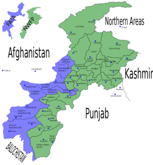
Kurram or Karam (
Urdu : کرم ) tribal agency is located in the FATA area ofPakistan .Geogrpahically it coversKurram Valley (Urdu: وادی کُرم) which is a beautiful valley in the northwestern part of Pakistan neighboring Afghanistan.Until the year 2000, when divisions were abolished, Kurram District used to be part of the
Peshawar Division of theNorth-West Frontier Province of Pakistan.The name Kurram comes from the river Kurram which flows along the valley. The valley in the north is surrounded by white mountains (the safed Koh) which also forms the natural border with Afghanistan.The
Kurram River drains the southern flanks of theSafed Koh mountain range, and enters the Indus plains north ofBannu . It flows west to east and crosses thePaktia Province Afghan-Pakistan border at coord|33|49|N|69|58|E| about 80 km southwest ofJalalabad , and joins theIndus nearIsa Khel after a course of more than 320 km (200 miles). The district has an area of 3,310 km² (1,278 sq. miles); the population according to the 1998 census was 448,310 [ [http://www.fata.gov.pk/index.php?link=6 Population (FATA, 1998) - Fata.gov.pk] ] . It lies between theMiranzai Valley and the Afghan border, and is inhabited by thePashtun Turi s, a tribe ofTurki andPathan origin on the western and central side who are supposed to have subjugated theBangash Pashtun about six hundred years ago. The language of the tribe is Pashto, but unlike majority of the Pashtuns they areShia s. Eastern protion of the valley is now inhabited mostly by Sunni Pukhtoons mostly Mangals and Paras and Sunni Bangash.History
The Kurram Valley in ancient times offered the most direct route to
Kabul andGardez . The route crossed thePeiwar Kotal Pass 3,439 m (11,283 ft) high, just over 20 km west of modernParachinar , but was blocked by snow for several months of the year.The valley is highly irrigated, well peopled, and crowded with small fortified villages, orchards and groves, to which a fine background is afforded by the dark pine forests and alpine snows of the Safed Koh. The beauty and climate of the valley attracted some of the Mughal emperors of Delhi, and the remains exist of a garden planted by
Shah Jahan . According to the Gazetteer of Kurram, the richness of the land gradually weaned the Turks from their nomadic life. Sections built villages and settled permanently; they ceased to beKuchi and became Kothi this abandonment of their nomadic habits by the majority of the resulted, as it was bound to do, in a contraction of the area in effective possession. The upper Kurram plain was safe as their head-quarters, but hills and slopes below theSafed Koh andMandher over which their graziers had kept an efficient watch, now afforded a menace as a place in which an encroaching tribe could established itself. To guard against this settlements ofMangale s andMuqbol s were half invited half allowed to push themselves in conditions of vassalage, and on promise to afford a buttress against any enemy aggression. In the lower Kurram, where for climatic reasons candidates for settlements were fewer, the problem was not easily solved. The Chardi Turis seem to have been the first to abandon their nomadic life.As the numbers who went down to graze every year became less,the area under control contracted.Sangroba andHadmela were left far behind and as theTuri s receded theWatizai Zaimushts gradually pushed in, until all that was left was a settlement at and about Alizai. On the western side the Saragallas retained, and still largely retain their habits. They too put in settlements around Biliamin and after much intervening warfare had finally to admit Bangashes brother not as vassals, but for the rest they retain unimpaired the rights on the western bank which they acquirerd at the time the conquest.With Chardis this was for from being the course left unsupported by their Kuchis they maintained a precarious existence at Alizai until even then they had to give three-fifths of their land to the Watizai Zaimushts in return for their assistance in a feud they had entered upon with Bilyamin. Consequently the hills and the grazing grounds passed from the Turizun to the Zaimushtzun and as the other Zaimushts section being unopposed had settled themselves on the left bank below Sadda.
In the early 19th century the Kurram Valley was under the government of
Kabul , and every five or six years a military expedition was sent to collect the revenue, the soldiers living meanwhile at free quarters on the people. It was not until about 1848 that the Turis were brought directly under the control of Kabul, when a governor was appointed, who established himself in Kurram. The Turis, beingShiah Muslims , never liked the Afghan rule.During the second Afghan War, when Sir Frederick Roberts advanced by way of the Kurram Valley and the Peiwar Kotal to Kabul, the Turis lent him every assistance in their power, and in consequence their independence was granted them in 1880.
The administration of the Kurram Valley was finally undertaken by the British government, at the request of the Turis themselves, in 1890. Technically it ranked, not as a British district, but as an agency or administered area.
Two expeditions in the Kurram Valley also require mention: (1) The Kurram expedition of 1856 under Brigadier-General Sir Neville Chamberlain. The Turis on the first annexation of the Kohat district by the British had given much trouble. They had repeatedly leagued with other tribes to harry the Miranzai valley, harbouring fugitives, encouraging resistance, and frequently attacking Bangash and Khattak villages in the
Kohat district. Accordingly, in 1856 a British force of 4,896 troops traversed their country, and the tribe entered into engagements for future good conduct. (2) The Kohat-Kurram expedition of 5,897 under Colonel W. Hill. During the frontier risings of 1897 the inhabitants of the Kurram valley, chiefly the Massozai section of theOrakzai s, were infected by the general excitement, and attacked the British camp atSadda and other posts. A force of 14,230 British troops traversed the country, and the tribesmen were severely punished. InLord Curzon 's reorganization of the frontier in 1900-1901, the British troops were withdrawn from the forts in the Kurram Valley, and were replaced by the Kurram militia, reorganized in two battalions, and chiefly drawn from the Turi tribe.In recent years the Kurram Valley has once again assumed a very strategic position and has been an area of intense military activity between the
Taliban and American and allied forces.Major locations
Parachinar Cantonment
Parachinar is the political head quarter of Kurram valley. It has offices of political agent, levy, and Kurram Militia, part of Frontier core (FC). It is located on the western and northern side of the valley. This makes it a part of Upper Kurram. The name of Parachinar comes from 'Para', one of the tribes of the valley and 'Chinar', the maple trees which are found in abundance in Kurram value in general and Parachinar in particular.The town of Parachinar has population around thirty thousand with Turi majority. The town has government hospital and many government schools.adda
Sadda is capital of Lower Kurram. FC maintains there posts here. It is mostly inhabited by Sunni tribes now and most of the Turis have left. There was also a sizeable sikh population but most of them have left the valley.
Peiwar
Peiwar is located on the north west corner of the valley. It is raised plateau and has many small villages. Most of the area is inhabited by Turis. Piwar is important for political and geographical reasons
Major Dams
Maulana dam
Maulana dam is a small dam in Safed Koh north of Parachinar city. It is close to Maulana village and is famous for its scenic beauty.
Zeran dam
Zeran dam is located on north east of Prachinar. It is also famous for its scenic beauty.
Climate
Climate of the valley is very pleasant all year around. In winters it can become slightly cold with temperature reaching -20 degree Celsius. It also snows in northern and western parts of the valley. Apart from that weather is pleasant all year around with much precipitation during spring and summer season. Autumn and winter are usually dry.
Flaura and Fauna
The valley has wide variety of plant and animal species.
Mentioned in
Rigveda In the
Rigveda , the Kurrum is mentioned as "Krumu". [http://www.tri-murti.com/ancientindia/rigHistory/ch4.htm]Taliban Activity
In recent years the Kurram Valley has once again assumed a very strategic position and has been an area of intense military activity between the
Taliban and American and allied forces.Pictures
local people of kurram agency have realized that longlasting peace can only be achieved by abondoning the taliban activities in the region and controlling thier influx into the agency as well.the people of different communities have assured thier support in this regard and realized the need of practical steps in this regard.
References
* Bowles, Gordon T. (1977). "The People of Asia". London. Weidenfeld & Nicolson.
* Scott-Moncrieff, Major-General Sir George K. "The Roads of the North-West Frontier." "Blackwood’s Magazine", No. MCCCIV, Vol. CCXV, June 1924, pp. 743-757.
* Swinson, Arthur (1967). "North-West Frontier". Frederick A. Praeger, New York, Washington.
ee also
*
Beliamen
*Kurram Agency War April 2007 External links
* [http://www.fata.gov.pk/index.php?link=6 Fata's official site]
* [http://www.khyber.org/places/2005/KurramAgeny.shtml Short description of Kurram Agency]
* [http://www.khyber.org/pashtohistory/frontiercorps/kurrammilitia.shtml Brief and partial history of Kurram Agency]
* [http://www.ansijournals.com/pjbs/2003/1368-1375.pdf Medicinal plants of Kurram Agency]
* [http://www.kurramvalley.8k.com Briefly All about Kurram Agency]

Wikimedia Foundation. 2010.