- Uvac
Infobox River | river_name = Uvac
image_size = 180px
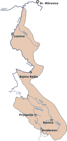
caption = Drainage basin of Drina in Serbia
origin =Ninaja mountain,Pešter plateau
mouth =Lim river , nearPriboj
basin_countries =Serbia ,Bosnia and Herzegovina
length = convert|119|km|mi|0|lk=on|abbr=on
elevation =
discharge = 18 m³/s
watershed = convert|1310|km2|sqmi|0|lk=on|abbr=on The Uvac (SerbianCyrillic : Увац) is the river in southwesternSerbia andRepublika Srpska ,Bosnia and Herzegovina , 119 km long right and major tributary of the Lim, loosely making the northern border of theSandžak /Raška region. Before it empties into the Lim, for a 10 kilometers it forms the border between Serbia and Bosnia and Herzegovina.Upper course
The Uvac originates in the
Pešter plateau from theNinaja mountain, as "Rasanska reka" (Cyrillic: "Расанска река"). The stream curves around the Ninaja andPometenik mountains, next to the villages of Tuzinje, Rasno, Dragojloviće and Gradac, where it meets "Brnjička reka" (Cyrillic: "Брњичка река"), enters theSjenica depression and continues on depression eastern border as the "Vapa" (Cyrillic: "Вапа"), which is 25 kilometers long and drains an area of 496 km².The river passes next to the villages of Gornja Vapa, Donja Vapa, Čedovo and Krstac, where the Vapa receives from the left the short river Uvac, which originates on the
Ozren mountain, and gives name to the downstream course of the river.Lower course
The Uvac continues to the northwest, enters the
Stari Vlah region where it flows in a deep, canyon-like valley, where it receives the "Kladnica" river from the right and generates lots of power, which is used for three powerful hydroelectric power stations, each one with big artificial lake: "Bistrica" withLake Radoinja , "Kokin Brod " withLake Zlatar (7,3 km², altitude 400 m, depth 40 m) and "Sjenica" withLake Sjenica .In the lowest part of its course, The Uvac flows between the
Zlatar andZlatibor mountains, next to the villages of Kokin Brod and Radoinja until it reaches the Bosnian border and Varda mountain, makes a sharp, elbow turn to the south and after a short flow next to the villages of Bjelušine and Uvac (both on Bosnian side), the Uvac empties into the Lim, north of the city ofPriboj .The Uvac drains an area of 1,310 km², belongs to the
Black Sea drainage basin , and its not navigable. Its average discharge at the mouth is 18 m³/s.References
* "Mala Prosvetina Enciklopedija", Third edition (1985); Prosveta; ISBN 86-07-00001-2
* Jovan Đ. Marković (1990): "Enciklopedijski geografski leksikon Jugoslavije"; Svjetlost-Sarajevo; ISBN 86-01-02651-6External links
* [http://www.uvac.org.rs/ Uvac Special Nature Reserve]
Wikimedia Foundation. 2010.